
Verbascum urumiense Sotoodeh, 2022
|
publication ID |
https://doi.org/ 10.11646/phytotaxa.538.1.3 |
|
DOI |
https://doi.org/10.5281/zenodo.6344542 |
|
persistent identifier |
https://treatment.plazi.org/id/487B878A-0F15-C67E-C9AD-F9EA3E222D54 |
|
treatment provided by |
Plazi |
|
scientific name |
Verbascum urumiense Sotoodeh |
| status |
sp. nov. |
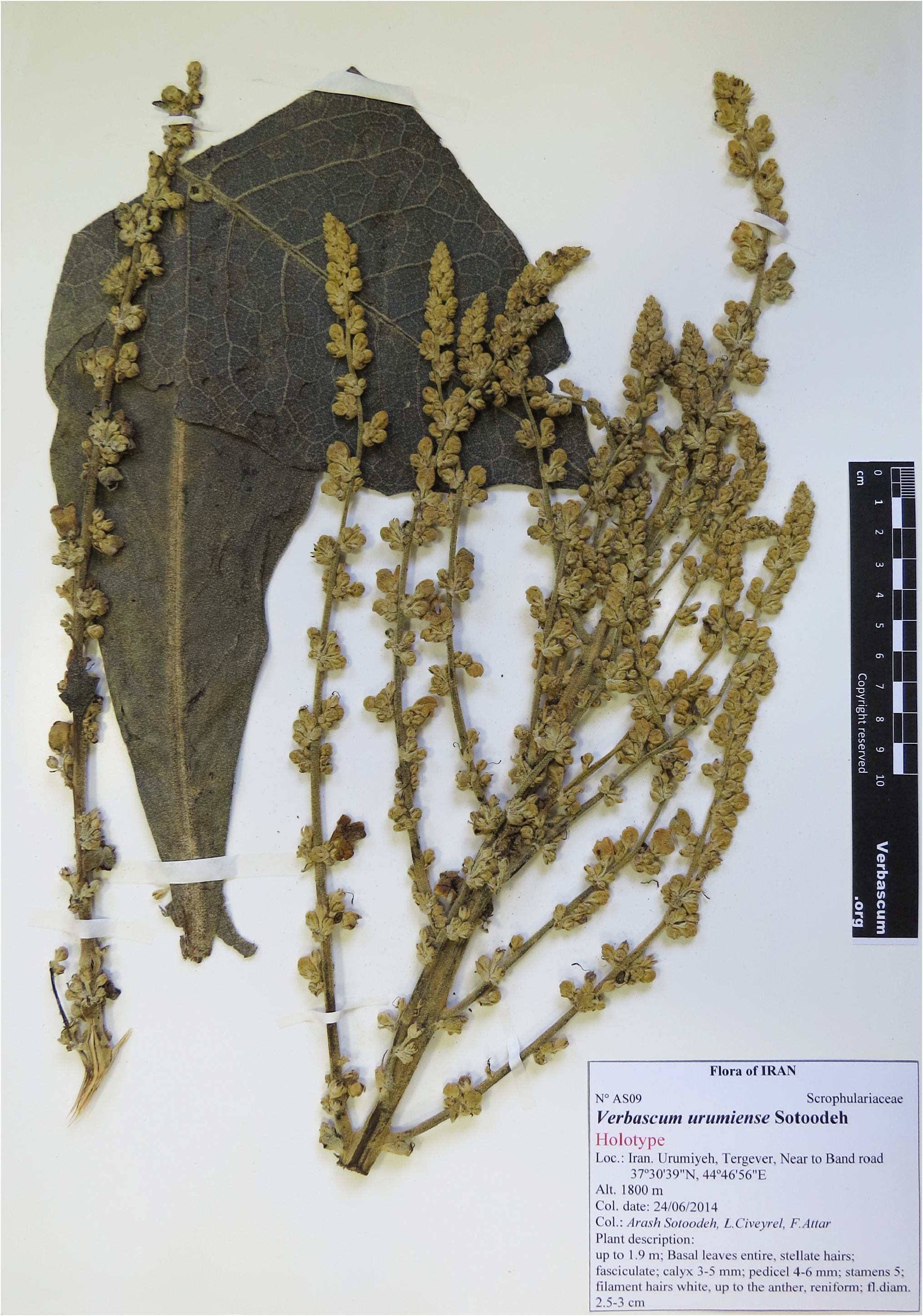
Verbascum urumiense Sotoodeh , sp. nov., ( Figures 3 View FIGURE 3 & 4a–c View FIGURE 4 ).
Type: — IRAN. Western Azerbaijan: W Urumiyeh, Tergever, near Band road, 1800 m, 37º30’39”N, 44º46’56”E, 24 June 2014, A. Sotoodeh, L. Civeyrel & F. Attar GoogleMaps AS 09 (holotype TUH!, isotypes G!, P!) .
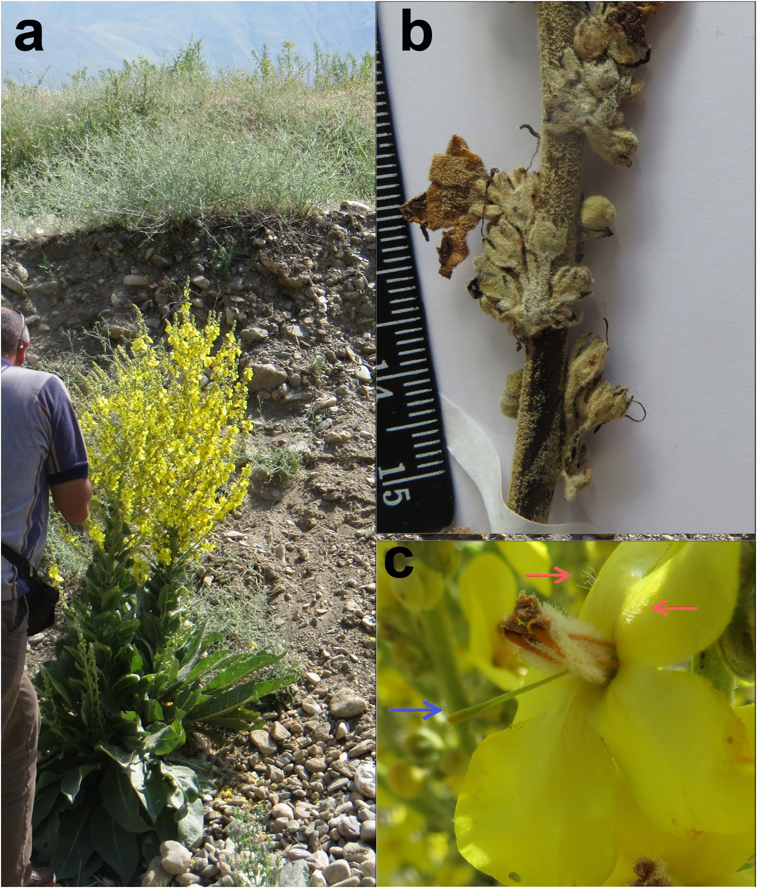
Diagnosis: — Verbascum urumiense is similar to V. erianthum Bentham (1846: 235) and V. songaricum by its habit, in having stellate whitish hairs, basal leaves of similar size, and broad panicles. However, they consistently differ in several morphological characters. Verbascum erianthum has rounded stems (vs. angular in V. urumiense ), greyish or yellowish stellate hairs all along the plant (vs. whitish stellate hairs), petiolate basal leaves (vs. sessile), oblong or ovate-oblong, obtuse denticulate or angular-crenate basal leaves (vs. elliptic, entire), pedicel two times longer than the calyx (vs. equal or little longer), orange hairs on filaments (vs. whitish hairs), corolla without pellucid glands inside (vs. with pellucid glands); and V. songaricum has rounded or striated, and obscurely angular stems (vs. angular in V. urumiense ), greyish or yellowish stellate hairs all along the plant (vs. whitish stellate hairs), petiolate basal leaves (vs. sessile), oblong- to linear-lanceolate, distinctly crenulated or entire (vs. elliptic, entire), calyx 6–10 mm (vs. 3–5 mm), corolla without pellucid glands and glabrous inside (vs. with pellucid glands, sparse ciliated) ( Table 2 View TABLE 2 ).
Plant biennial, covered by whitish stellate hairs along the stems, leaves, and upper inflorescence portion. Stem 1.7–1.9 m tall, erect, angular, leafy. Basal leaves, elliptic, 30–41 × 8–12 cm, base attenuate, apex broadly acute, margin entire, not decurrent; sessile. Cauline leaves similar to basal ones but smaller, not decurrent. Inflorescence dense, branched, forming a broad panicle, clusters of 2–7 flowers at the axil of each bract; bracts 5–7 mm long, ovate-lanceolate, acuminate; bracteoles 2, up to 4 mm long; pedicel 5–7 mm long, equal or a little longer than calyx; calyx 3–5 mm long, divided up to ¾ into five lobes, acute. Corolla yellow, 25–30 mm diam., tube up to 1 mm long, stellate-hairy outside, ciliated inside, with pellucid glands. Stamens 5, filament hairs white, up to the anther; anthers all reniform. Style up to 11 mm long, Stigma spathulate, decurrent along the style. Capsule not seen.
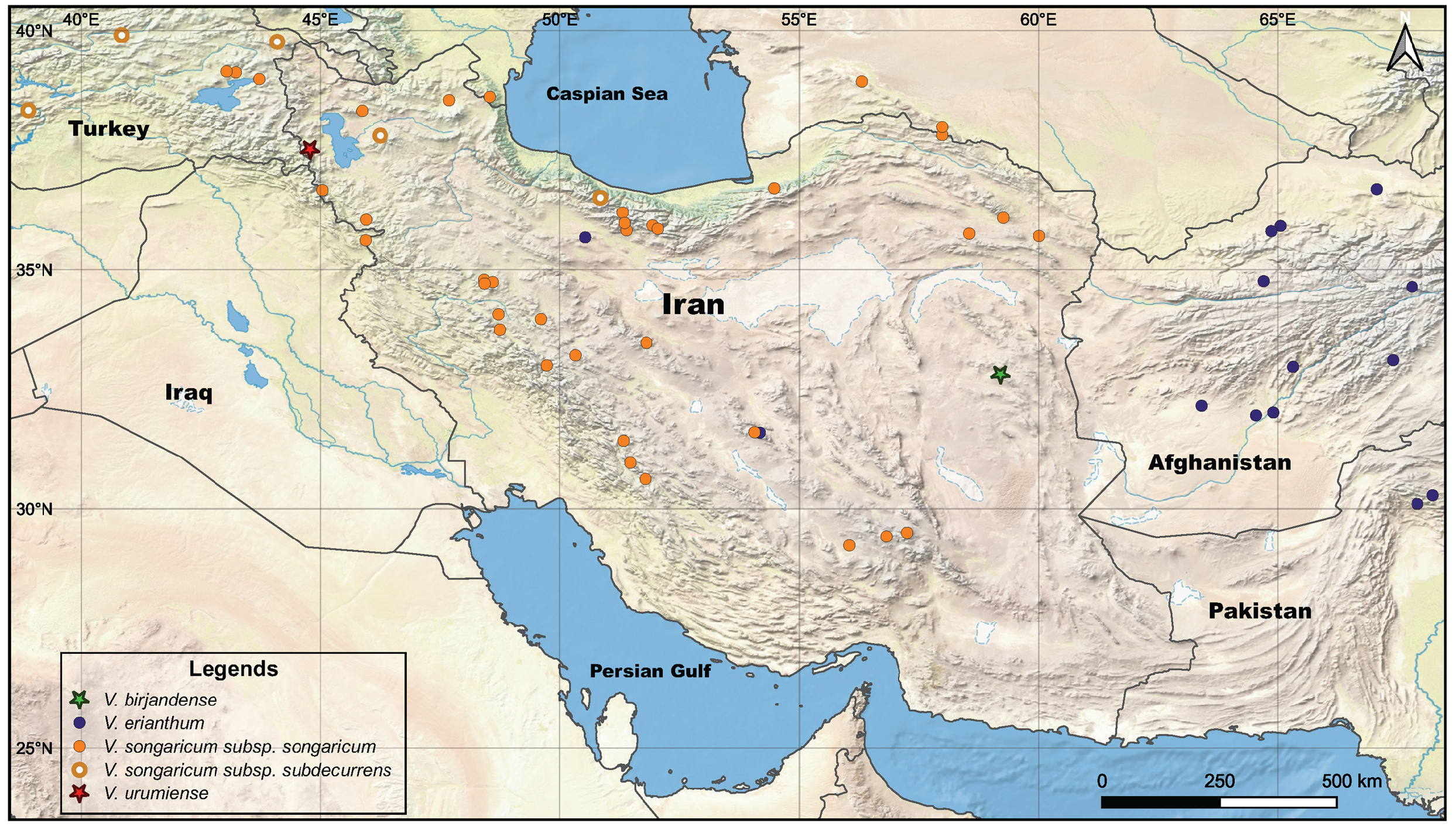
Distribution and habitat: —This new species is known only from the type locality, endemic to Iran. It is an Irano-Turanian element, and distributed in western Azerbaijan province, the west part of the city Urumiyeh and its lake ( Figure 2 View FIGURE 2 ). The region is mountainous with an elevation varying between 1300 to 3400 m, so the temperature in this area does not rise above 30 degrees Celsius in summer and the peak of heat is in July and August ( Günther 1899, Sarvar et al. 1970). From the beginning of autumn, the cold and frost affect the region. Precipitations reach a maximum of 600 mm per year ( Günther 1899, Zohary 1973). This area is relatively rich in woody perennials, annuals and herbaceous plants like those of the genera Acantholimon Boiss. , Astragalus L., Centaurea L., Cousinia Cass. , and Thymus L., forming vast pastures. Shrub and tree genera like Acer L., Cotoneaster Med. , Crataegus L., Prunus L. s.l., or species such as Malus orientalis Uglitzk. , Pyrus elaeagnifolia Pall. , Salix alba L. and Salix excelsa S.G.Gmel. are commonly found around. The small population of Verbascum urumiense was found scattered at the margin of fields and roads in sandy, calcareous lithosols.
Phenology: —Flowering and fruiting occur from June to August.
Etymology: —The specific epithet of the new species refers to its type locality, the city and lake of Urumieh, in western Iran.
Additional general comments: —Based on the narrow distributions and close morphological characters, we suspect that Verbascum birjandense and V. urumiense may have evolved from a common ancestor with V. erianthum and V. songaricum , respectively, through two distinct mountain ranges. Not surprisingly, Urumiyeh and Khorassan mountain ranges are known to be high hotspots for endemic species ( Manafzadeh et al. 2014, Noroozi et al. 2019). This observed endemism might be explained by a recent differentiation from the parent species, which are likely to extend their range and gene pool. In our case, these emerging species would differ from the ancestral forms only by a few minor characters and would be favored by the mountain geographical barrier. Nonetheless, it is necessary that these hypotheses could be evaluated under different sources of evidence, including molecular phylogenetic and phylogeographic analyses.
Examined specimens
Verbascum erianthum : AFGHANISTAN. Baghlan, Hesar village, riverbanks, 1800 m, 24 July 1972, I. Kukkonen 7524 (G!); Parwan, E of Shibar Pass, ca. 40 km E of crossing to Dosi on road Bamiyan-Charikar GoogleMaps , 2400 m, 21 July 1972, I. Kukkonen 7413 (G!); Baghlan, 7 km N of Dosi on the road from Khenjan GoogleMaps to Pule-Khumri GoogleMaps , E of Jangalmiri, 780 m, 21 May 1972, I. Kukkonen 1098 (G!); Kuram valley GoogleMaps , 5000–7000 ft, 14 June 1879, J.E.T. Aitchison 645 (BM!); Kuram valley GoogleMaps , 5000–7000 ft, 28 May 1879, J.E.T. Aitchison 440 (K!); Southside of Kuh-i-Baba GoogleMaps , 6 miles downstream from Panjou, 27 August 1954, 8500ft, W. Thesiger 105 (BM!); to the east of Pol-i-Khormi GoogleMaps , 10 June 1962, Hedge & Wendelbo W-4043 (E, image!); Kabul, Sher Darwasa GoogleMaps , steep stony slopes, 13 May 1962, 1900 m, Hedge & Per Wendelbo W-3180 (E, image!); Prov. Takhar: Unteres Bangi-Tal GoogleMaps , 2 km nordlich von Afaqi, ca. 680 m, 26 June 1965, D. Podlesh 11528 (E, image!); Prov. Badakhshan: Yawarzen GoogleMaps , ca. 30 km S of Qeshm, 1400 m, 30 June 1969, Hedge & Wendelbo W-9307 (E, image!); Prov. Baghian: Khinjan-Tal GoogleMaps , Hänge an der StraBe GoogleMaps zum Salang-Pass, 2000m, 27 June 1965, Podlech GoogleMaps 11546 (E, image!); Kabul, in the vicinity of Panjao GoogleMaps , steep stony slopes, 2700 m, 03 July 1962, Hedge & Wendelbo W-4986 (E, image!); Prov. Kabul: in faucibus Tang-e Gharru GoogleMaps inter Kabul et Sarobi GoogleMaps , ca. 34º32’N, 69º25’E, substr. Gneiss, ca 1400–1500 m, 17 June 1962, K.H. Rechinger 16940 (K, image!); Faizabad district GoogleMaps to Meshed, Warduj Valley GoogleMaps , 30 m West Faizabad GoogleMaps , 3500 m, 01 July 1964, P. Furse 6444 (K, image!); Shibar to Doshi 10 m from Doshi, 14 May 1964, P. Furse 5911 (K, image!); Mashad to Faisabad Bedakhshan, 3500 m, 20 May 1964, P. Furse 6159 (K, image!); Prov. Orozgan: Syahdara bei Dahane Khubak, 2420 m, 29 July 1970, D. Podlech 19037 (K image!); Prov. Laghman: Alishang-Tal Bei Sakarman, 950 m, 05 April 1970, D. Podlech 17560 (K image!). IRAN. Baluchistan, 1851, J. F. Stocks 1043 (K!); Baluchistan , 4000 ft, 8 June 1996, J.F. Duthie 18950 (K!). PAKISTAN. Near Sarai Bala GoogleMaps , between Chakdara and Timargara, 15 June 1987, Ghafoor & Omer 2328 (G!); E Sanjawi, 30º16’N, 68º25’E, 1400 m, 16 May 1965, Rechinger 24544 (G!); Pishawar, Tor Khama, 34º08’N, 71º10’E, ad confines Afghaniae, 700 m, 29 May 1965, Rechinger 24544 (G!); Kurram, Parachinar, 33º56’N, 70º04’E, 1500–1700 m, Rechinger 30947 (G!); Chitrah, Drosh, 03 June 1968, 4500 ft (1300 m), J.D.A. Stainton 2581 (BM!);
Verbascum songaricum : AFGHANISTAN. Badghis,> 3000 m, 1885, Aitchison (K!) ; IRAN. Alborz, Hezarband , 1935, Parsa 4826 (TEH!) ; Alborz, Hezarband, 2500 m, 1936, Parsa 4828 (TEH!); Karaj , Elborz 20 ’ NE of Karaj, 6000 ft, 1962, Furse 2604 (K!); Kuh-Dena, 1842, Kotschy 692 (BM!) ; Khorasan, Mont Hazar Masjid , 1200–1600 m, 1948, Rechinger 5014 (K!) ; Khorasan, Mont Hazar Masjid , 1200–1600 m, 1948, Rechinger 5014 (BM!) ; Khorasan, Mont. Hazar Masjid , 1200–1600 m, 1948, Rechinger 4999 (K!) ; Khorasan, Mont Kuh-e-Bizg , 2000 m, 1937, Rechinger 1401 (K!) ; Kurdistan, Baneh , 1922 m, 2003, Assadi s.n. ( IRAN!) .
V. songaricum subsp. songaricum : IRAN. Kurdistan & Luristan, 1852 (BM!); Isfahan, 2760 (E, image!) .
V. songaricum : IRAN. Nishapour, 1858, Bunge (K!); Shahrestanak, 9000 ft, 1935, Rechinger 594 (BM!). RUSSIA. 1914, (K!); 1960, Ruldugin 4434 (BM!).
V. songaricum subsp. subdecurrens : IRAN. Shahsavar, Sehezar road, 1300 m, 30 June 2014, Sotoodeh, Civeyrel, Attar AS 26 (TUH!); Tabriz, Kandovan village , 2164 m, 26 June 2014, Sotoodeh, Civeyrel, Attar AS12 (TUH!); TURKEY. Erzurum, 1984, 1550 m, Nydegger 19249 (E, image!); Hakkari, 1967, 1950 m, Duncan & Tait 228 (E, image!); Hakkari, Nehil Cayi, 1966, 1800 m, Davis 45857 (E, image!); V. songaricum : Hakkari, Zap gorge, 6 km N of the junction of Hakkari-Van and Yukesekova roads, 1800 m, 1966, Davis 45839 (K!) ;
V. songaricum subsp. songaricum: Mt Kara Tau, Schrenk (isotype BR, image BR 0000005422548!).
No known copyright restrictions apply. See Agosti, D., Egloff, W., 2009. Taxonomic information exchange and copyright: the Plazi approach. BMC Research Notes 2009, 2:53 for further explanation.
|
Kingdom |
|
|
Phylum |
|
|
Class |
|
|
Order |
|
|
Family |
|
|
Genus |