
Etheostoma rupestre rupestre Gilbert and Swain 1887
|
publication ID |
https://doi.org/10.11646/zootaxa.5343.2.3 |
|
publication LSID |
lsid:zoobank.org:pub:A161A7F5-7B39-49DB-B41E-B1AD0F56C94F |
|
DOI |
https://doi.org/10.5281/zenodo.8324679 |
|
persistent identifier |
https://treatment.plazi.org/id/394487F6-A165-D508-FF22-66FF0358F932 |
|
treatment provided by |
Plazi |
|
scientific name |
Etheostoma rupestre rupestre Gilbert and Swain 1887 |
| status |
|
Etheostoma rupestre rupestre Gilbert and Swain 1887 View in CoL View at ENA
Tsai’s Rock Darter
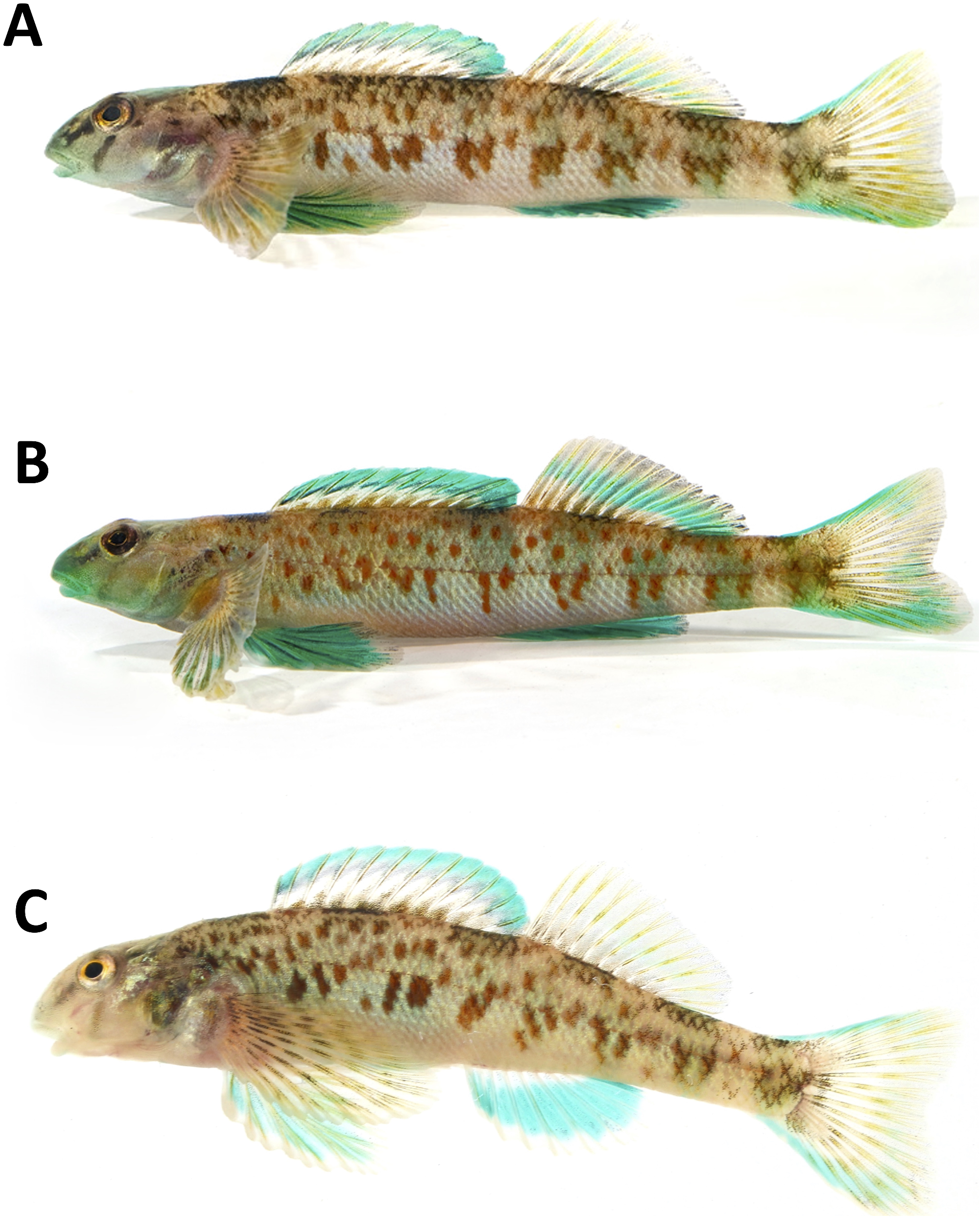
Figure 8A View FIGURE 8 , Tables 1–11 View TABLE 1 View TABLE 2 View TABLE 3
Holotype. USNM 36695 About USNM , same as species lectotype.
Paratypes. USNM 188971 About USNM (17, 22–33), same as species paralectotypes .
Materials examined (nontypes).
Tombigbee River drainage: Alabama. Fayette Co., USNM 398674 About USNM , (1, 56), Harris Creek , co. rd. 53, 33.7451, -87.7593, 8 March 2010, A. M. Janosik, C. E. Johnston and T. H. Haley GoogleMaps ; USNM 398675 About USNM , (5, 42–52) mm SL, same locality, 8 March 2010, A. M. Janosik, C. E. Johnston and T. H. Haley. GoogleMaps Marion Co., AUM 49010 View Materials , Buttahatchee River , downstream site of Buttahatchee Dam,. 75 miles NNE of Pearces Mill (1, 45), 18 July 2007, 34.1261º, - 87.8369º; GoogleMaps AUM 49032 View Materials , same locality, (7, 46–49), 14 July 2007, 34.1261º, -87.8369º . AUM 23708 View Materials , McConegal Creek , tributary to Bull Mountain Creek, 8.9 km NNW of Bexar Co. Road 56 (3, 32–38), 12 July 1982, 34.2663°, - 88.1667º . Sumter Co., AUM 68120 View Materials , Alamuchee Creek , at Hwy. 80, 3.8 km ENE of Cuba (13, 40–55), 11 November 2016, 32.4387º, -88.3376º. Mississippi. Lowndes Co., AUM 20642 View Materials , Tombigbee River , Buzzard Island 8.4 km S of Columbus (35, 30–40), 11 September 1979, 33.4200º, -88.4110º . AUM 3351 View Materials , unnamed creek, small tributary to Buttahatchee River 8.0 km N of Caledonia on gravel road (2, 36–43), 02 October 1968, 33.7126º, -88.3200º . Monroe Co., AUM 20489 View Materials , Tombigbee River , 6.6 km W of Amory on Highway 278 (13, 29–41), 12 September 1980, 33.9820º, -88.5190º .
Black Warrior River and North River drainage: Alabama. Jefferson Co., UAIC 3324 View Materials , Cunningham Creek , 1.6 km S of Morris (Locust Fork) U.S. Route 31 (3, 40–45), 17 August 1969, 33.7403º, -86.8119º . Tuscaloosa Co., UAIC 676 View Materials , Big Sandy Creek (1, 41), 07 February 1959, 33.0360º, -87.5870 º ; UAIC 834 View Materials , (10, 38–48), 16 February 1962, 33.0337º, -87.5821º; UAIC 409 View Materials , Gulf States Paper Company Picnic Grounds (5, 36–47), 10 August 1954, 33.0333º, -87.6083º. UAIC 804 View Materials , Big Sandy Creek and Big Sandy Spring (3, 34–42), 12 May 1961, 33.0337º, - 87.5821º . UAIC 1218 View Materials , Big Sandy Spring , 8.0 km SE of Coaling (1, 33), 20 February 1964, 33.1011º, -87.3261º; UAIC 1225 View Materials , same locality (3, 34–44), 08 March 1964, 33.0337º, -87.5821º ; UAIC 1445 View Materials , same locality (3, 35–41), 12 August 1964, 33.0337º, -87.5821º . UAIC 1243 View Materials , Carroll Creek , Highway 69, 16.1–24.1 km N of Tuscaloosa (North River) (4, 32–39), 16 April 1964, 33.29417º, -87.5697º; UAIC 3029 View Materials , Highway 69, 6.4 km N of junction of Highway 69 and U.S. Highway 82 (North River) (1, 53), 11 August 1968, 33.2942º, -87.5697º. UAIC 929 View Materials , Cottondale Creek , Keene’s Mill Road (4, 31–46), 05 November 1962, 33.1828º, -87.4425º ; UAIC 1792 View Materials , 1.6 km N of Cottondale (3, 31–33), 04 December 1965, 33.2006º, -87.4462º. UAIC 1158.03 View Materials , Hammer Creek , 6.4 km off Watermelon Road, 13.8 km N of Tuscaloosa (9, 31–48), 30 January 1963, 33.3389º, -87.5258º . UAIC 59 View Materials , Hurricane Creek , 183 m downstream of confluence of North Fork (1, 45), 26 September 1950, 33.2203º, -87.3108º . UAIC 61 View Materials , Lower Cottondale Creek (1, 36), 09 October 1956, 33.1947º, -87.4397º; UAIC 58 View Materials , 0.8 km upstream of confluence of Hurricane Creek (1, 31), 05 July 1950, 33.2057º, -87.4467º. USNM 36695 About USNM , North River , Tuscaloosa (1, 31), 1884, no lat/long. available ; UAIC 1181 View Materials , crosses Highway 69 17.7 km N of Tuscaloosa (30, 34–48), 23 September 1963, 33.3539º, -87.5572º ; UAIC 1182 View Materials , Watermelon Road , 11.3 km NE Tuscaloosa (10, 30–44), 01 October 1963, 33.2914º, -87.5128º; UAIC 1194.03 View Materials , 3.2 km upstream of Highway 69, 12.9 km N of Northport (43, 28–47), 18 November 1964, 33.3461º, -87.5786º ; UAIC 2696 View Materials , 18.0 air km N of Northport (8, 33–44), 19 September 1967, 33.3964º, -87.5797º; UAIC 3026 View Materials , unnamed dirt road 1.6 km W of Highway 69 at Macedonia Church (1, 28), 31 July 1968, 33.3528º, -87.5725º; UAIC 3522 View Materials , 12.9 View Materials air km N of junction of U.S. Highway 82 and Highway 69 (2, 40–42), 25 April 1969, 33.3528º, -87.5725º . UAIC 2576 View Materials , Rice Mine Creek , 3.2 km E of U.S. Highway 82 (3, 36–45), 21 January 1967, 33.2369º, -87.5125º . UAIC 1303 View Materials , Swampy area , Springbranch on N side of U.S. Highway 82 and Big Sandy Creek at Duncanville (2, 35–35), 22 June 1964, 33.053º, -87.4267º. UAIC 1169 View Materials , Turkey Creek , Highway 69, 22.5 km N of Tuscaloosa (2, 32–32), 13 March 1963, 33.4097º, -87.5111º ; UAIC 1172 View Materials , 4.0 km W of Highway 69, 19.3 km N of Tuscaloosa (6, 30–37), 15 March 1963, 33.3969º, -87.5533º ; UAIC 1170 View Materials , N of Tuscaloosa on Highway 69 (1, 36), 16 June 1963, 33.4097º, -87.5111º; UAIC 3182 View Materials , Highway 69 (1, 31), 16 January 1973, 33.4097º, -87.5111º; UAIC 5847.09 View Materials , Highway 69 (3, 30–41), 19 November 1979, 33.4097º, -87.5111º ; UAIC 5835.13 View Materials , Highway 69 (2, 29–30), 24 October 1979, 33.4097º, -87.5111º ; UAIC 5879.04 View Materials , Highway 69 (1, 51), 18 December 1979, 33.4097º, - 87.5111º ; UAIC 5888.10 View Materials , Highway 69 (3, 28–39), 29 January 1980, 33.3523 º, -87.5537 º ; UAIC 5897.06 View Materials , Highway 69 (5, 28–33), 21 February 1980, 33.4097, -87.5111 GoogleMaps ; UAIC 7876.04 View Materials , 91 m downstream of Highway 69 (bridge crossing) (1, 47), 11 July 1987, 33.41º, -87.5092º ; USNM 188971 About USNM , Tuscaloosa (10, 28–31), 1884, no lat/long. available . UAIC 1198 View Materials , unnamed creek, at confluence of North River on Highway 69, 19.3 km N of Tuscaloosa (16, 31–46), 14 October 1965, 33.3556º, -87.5583º . UAIC 1150 View Materials , unnamed creek, Highway 69 at bridge crossing North River 15.3 km N of Tuscaloosa (6, 37–50), 10 January 1963, 33.3539º, -87.5572º; UAIC 1151 View Materials , bridge crossing North River off Highway 69, 15.3 km N of Tuscaloosa (5, 35–46), 08 March 1963, 33.3539º, -87.5572º. AUM 862 View Materials , unnamed creek, tributary to North River 14.8 km N of Junction 69 ( U.S. Highway 82 and Highway 69) (1, 44), 14 April 1968, 33.3840º, -87.5840º . USNM 166029 About USNM , (12, 33–46), unnamed creek, tributary to North River , 11.3 km N of New Lexington on U.S. Highway 43, 07 April 1952, 33.5740º, -87.6581º . UAIC 1647 View Materials , Black Warrior River , below dam at Tuscaloosa (1, 41), 29 June 1965, 33.2141º, -87.5756º.
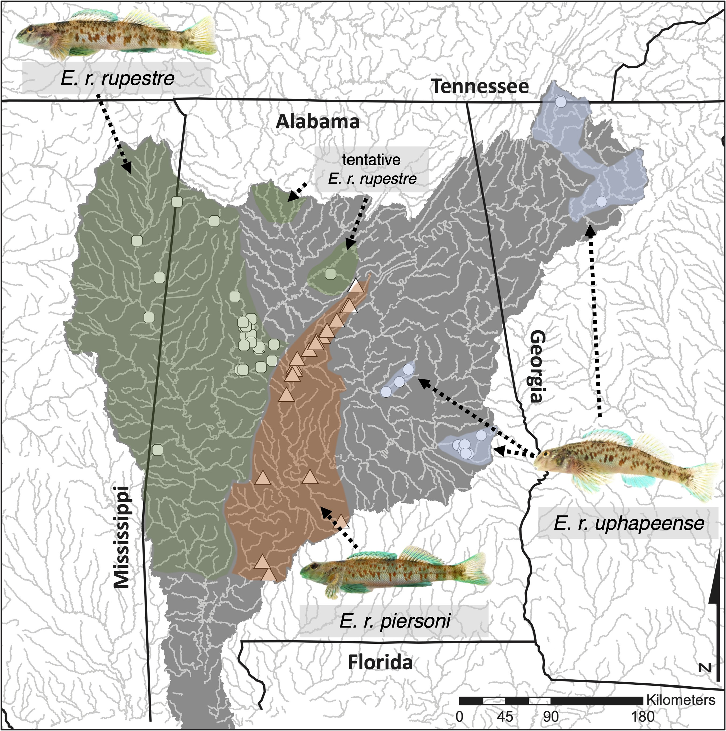
Diagnosis. While individuals of Etheostoma . r. rupestre cannot be morphologically distinguished from other subspecies due to overlap in all traits measured, entire populations can be diagnosed by the following tendencies: populations of E. r. rupestre have modally five scales above the lateral line (as opposed to six in both E. r. piersoni and E. r. uphapeense ) ( Table 2 View TABLE 2 ), tend to have low numbers of lateral line scales (usually 45–59 vs. 49–63 in other subspecies) ( Table 1 View TABLE 1 ), tend to have wide ranges of nape squamation (naked to fully scaled in E. r. rupestre vs.>40% in other subspecies) ( Table 7 View TABLE 7 ), and by having few lateral blotches along the midline that may often be diffuse (3–8 distinct blotches in E. r. rupestre vs. 5–9 in E. r. piersoni and 7–9 in E. r. uphapeense ) ( Table 9 View TABLE 9 ).
Description. Populations of Etheostoma r. rupestre possess the following traits: body ventrally flattened, lateral line scales 45–59 in>99% of specimens (modally 49–53) ( Table 1 View TABLE 1 ), scale rows above the lateral line 4–7 (modally 5) ( Table 2 View TABLE 2 ), scales below lateral line 6–12 (modally 8–9) ( Table 3 View TABLE 3 ), scales around the caudal peduncle 16–23 (modally 18–20) ( Table 4), dorsal-fin spines IX–XII (modally XI) ( Table 5 View TABLE 5 ), dorsal-fin rays 9–13 (modally 11–12) ( Table 6), nape squamation 0–100% (naked to fully scaled) (mean 75–80% squamation) ( Table 7 View TABLE 7 ), 10–90% belly squamation (mean 44–58%) ( Table 8), lateral blotches tend towards being few and diffuse (3–8 distinct blotches, mean 6.4) ( Table 9 View TABLE 9 ), distance between blotches 3.5–7.5% of SL (mean 4.8%), lateral blotch width 4.2–6.6% of SL (mean 5.5%), dorsal saddle width 5.8–9.1% of SL (mean 8.0) ( Table 10 View TABLE 10 ), distal band in first dorsal fin 21.4–48.2% of fin depth (mean 38.3%), total first dorsal pigment 59.0–74.6% of fin depth (mean 66.9) ( Table 11 View TABLE 11 ), nuptial coloration ranging from light blue to dark green.
Distribution. The range of Etheostoma . r. rupestre extends from the lower Tombigbee watershed in Alabama to the upper Tombigbee watershed of Mississippi and the Black Warrior watershed ( Fig. 2 View FIGURE 2 ). Etheostoma r. rupestre is disjunct from other E. rupestre subspecies.
Etymology. As species. The common name honors Chu-fa Tsai, who has contributed to the understanding of morphological divergence in E. rupestre .
| T |
Tavera, Department of Geology and Geophysics |
No known copyright restrictions apply. See Agosti, D., Egloff, W., 2009. Taxonomic information exchange and copyright: the Plazi approach. BMC Research Notes 2009, 2:53 for further explanation.
|
Kingdom |
|
|
Phylum |
|
|
Order |
|
|
Family |
|
|
Genus |