
Etheostoma rupestre piersoni, Hilburn, Janosik, and Johnston, 2023
|
publication ID |
https://doi.org/ 10.11646/zootaxa.5343.2.3 |
|
publication LSID |
lsid:zoobank.org:pub:A161A7F5-7B39-49DB-B41E-B1AD0F56C94F |
|
DOI |
https://doi.org/10.5281/zenodo.8329868 |
|
persistent identifier |
https://treatment.plazi.org/id/394487F6-A160-D515-FF22-600203E2FC20 |
|
treatment provided by |
Plazi |
|
scientific name |
Etheostoma rupestre piersoni, Hilburn, Janosik, and Johnston |
| status |
subsp. nov. |
Etheostoma rupestre piersoni, Hilburn, Janosik, and Johnston , New Subspecies Shamrock Darter
Figure 8B View FIGURE 8 , Tables 1–11 View TABLE 1 View TABLE 2 View TABLE 3
Etheostoma cf. rupestre — Near et al. 201l: 568, 578, Tbl 1., Fig. 3 View FIGURE 3 (recognition as a distinct lineage, termed Central Rock Darter).
Holotype. Alabama. Dallas / Wilcox Co., USNM 398677 View Materials , 61 mm SL, Chilatchee Creek , Hwy 5, 32.2359°, - 87.4091°, 26 March 2010, C. E. Johnston, A. M. Janosik, D. E. Holt and T. H. Haley.
Paratopotypes. USNM 398678 View Materials , (2, 43–46) mm SL, same locality, 32.2359°, -87.4091°, 26 March 2010, C. E. Johnston, A. M. Janosik, D. E. Holt and T. H. Haley .
Paratypes. Alabama and Cahaba River drainages : Alabama. Bibb Co., AUM 39178 View Materials , Cahaba River , 6.2 airmi NE of Centreville, Hwy 27 (5, 47–55), 23–24 October 1978 , no lat/long available; AUM 38753 View Materials , 0.6 miles downstream of the Harrisburg Bridge, at the first gravel island (14, 43–55), 6 November 1983 32.8545°,-87.2001°; AUM 2516 View Materials , 13.4 km N of Centerville on Highway 27 (2, 46–51), 13 May 1969 , 33.0636°, -87.1308°; AUM 5880 View Materials , 10.0 air km NE of Centerville on Highway 27 (21, 40–51), 21 November 1971 , 33.0394°, -87.1308°. AUM 18172 View Materials , Schultz Creek , 6.3 air km NNW of Centerville on Highway 219 (2, 30–48), 08 September 1978 , 33.0021°, -87.1483°. Butler Co., AUM 68107 View Materials , Cedar Creek, at Cedar Creek Plantation, 13 km NW of Greenville (1, 64), 13 October 2016 , 31.90968º, -86.71909º. AUM 74489 View Materials , Caffee Creek, riffle near Griffin Town Road (5, 46–58), 22 March 2022 , 33.12001º, -87.10619º. Dallas Co., AUM 7481 View Materials , Mush Creek , 4.8 air km S of Sardis on Highway 41 (2, 46–46), 03 April 1972 , 32.2444°, -86.9928°; AUM 7653 View Materials , 4.8 View Materials air km S of Sardis on Highway 41 (4, 34–51), 11 July 1972 , 32.2444°, -86.9928°; AUM 7813 View Materials , 4.8 View Materials air km S of Sardis on Highway 41 (14, 35–47), 17 October 1972 , 32.2444°, -86.9928°. Jefferson Co., AUM 47076 View Materials , Cahaba River , Grant’s Mill, downstream of Grant’s Mill Road bridge (1, 50), 5 October 2006 , 33.5110º, -86.6584º; AUM 49331 View Materials , Mill Dam site of Grant’s Mill , 1 mi SE of Moore Corner, AL (2, 47–51), 6 June 2007 , 33.5089º, -86.6436º; AUM 18694 View Materials , 11.1 View Materials air km WSW of Leeds on Highway 143 (5, 35–46), 28 March 1979 , 33.6604°, -86.5894°. Monroe Co., AUM 15507 View Materials , Big Flat Creek , 12.9 air km NW of Monroeville on Highway 14 (24, 34–54), 16 October 1977 , 31.6078°, -87.415°. USNM 199547 View Materials , Unnamed creek, tributary of Limestone Creek between Monroeville and Mexia (1, 47), 27 November 1962 , 31.5148°, -87.3559°. Monroe Co., AUM 48923 View Materials , Big Flat Creek , downstream site of Rikard’s Mill, 1 mile NNW of Fountain (2, 49–51), 22 July 2007 , 31.6084º, -87.4143º. Shelby Co., AUM 5699 View Materials , Cahaba River , 4.2 air km N of Marvel (1, 49), 16 May 1971 , 33.1867°, -86.9997°; AUM 56142 View Materials , 2.5 View Materials airmi WSW of Helena, Hwy 52 (1, 57), 5 December 1978 , 33.2846º, -86.8827º; AUM 6660 View Materials , at river mile 3.4 on J Foshee’s Cahaba Section 8 map (1, 53), 26 September 1981 , 33.2495º, -86.9370º; AUM 65819 View Materials , at river mile 1.5 on J. Foshee’s Cahaba Section 5 map (2, 44–57), 07 November 1981 33.4037º, -86.7572º; AUM 41174 View Materials , at Booth Ford , 4.5 airmi N of Marvel, Hwy 251 (2, 57–61), 6 October 1978 , no lat/long available; AUM 66613 View Materials , at river mile 5.0 on J. Foshee’s Cahaba Section 8 map (1, 48), 26 September 1981 , 33.2360º, -86.9430º; AUM 66657 View Materials , at river mile 4.0 on J. Foshee’s Cahaba Section 6 map (1, 46), 24 October 1981 , 33.3289º, -86.8441º.
Diagnosis. While there is considerable overlap among all traits measured rendering individuals undiagnosable, populations can be diagnosed. Populations of E. r. piersoni differ from E. r. rupestre by possessing modally six scales above the lateral line (as opposed to five in E. r. rupestre ) ( Table 2 View TABLE 2 ), by possessing a higher range of lateral line scales than populations of E. r. rupestre (49–63 in E. r. piersoni vs. usually 45–59 in E. r. rupestre ) ( Table 1 View TABLE 1 ), by having a much narrower range of nape squamation (>80% scaled in E. r. piersoni vs. 0–100% scaled in E. r. rupestre ) ( Table 7 View TABLE 7 ), and by having a higher number of lateral blotches (5–9 in E. r. piersoni vs. 3–8 in E. r. rupestre ) ( Table 9 View TABLE 9 ). Populations of E. r. piersoni can be distinguished from populations of E. r. uphapeense by possessing a lower range and mean of blotches that tend to be slightly more diffuse (5–9 distinct blotches in E. r. piersoni vs. 7–9 in E. r. uphapeense ) ( Table 9 View TABLE 9 ). E. r. piersoni and E. r. uphapeense can be further distinguished with genetics (see Janosik et al. 2023).
Description. Populations of E. r. piersoni possess the following traits: lateral line scales 49–62 (modally 54–60) ( Table 1 View TABLE 1 ), scales above the lateral line 5–7 (modally 6) ( Table 2 View TABLE 2 ), scales below the lateral line 6–11 (modally 8–9) ( Table 3 View TABLE 3 ), scales around the caudal peduncle 18–23 (modally 19–21) ( Table 4), dorsal spines X–XIII (modally XI–XII) ( Table 5 View TABLE 5 ), dorsal-fin rays 10–13 (modally 11–12) ( Table 6), Nape squamation 80–100% (mean 92–96%) ( Table 7 View TABLE 7 ), belly squamation 40–90% (mean 58–60%) ( Table 8), distinct lateral blotches 5–9 (mean 7.0) ( Table 9 View TABLE 9 ), distance between lateral blotches 2.8–6.6% of SL (mean 4.6%), average lateral blotch width 4.6–8.2% of SL (mean 6.2%), average dorsal saddle width 6.6–8.8% of SL (mean 7.9%) ( Table 10 View TABLE 10 ), male distal band in first dorsal fin 24.9–51.1% of fin depth (mean 39.6%), total first dorsal pigment 49.2–78.0% of fin depth (mean 64.0%) ( Table 11 View TABLE 11 ), nuptial coloration ranging from light blue to dark green.
Distribution. Etheostoma rupestre piersoni is endemic to the Alabama and Cahaba watersheds of central Alabama ( Fig. 2 View FIGURE 2 ). It is allopatric to E. r. rupestre and E. r. uphapeense .
Etymology. Named in honor of J. Malcom Pierson, an ichthyologist who made outstanding contributions to the study of Alabama’s ichthyofauna. Shamrock Darter refers to the nuptial color and pattern as it resembles that of Shamrock leaves. The common name serves as a double entendre for a derivation of the original Rock Darter (“ sham-” (false derivative) “- rock” (Rock Darter)).
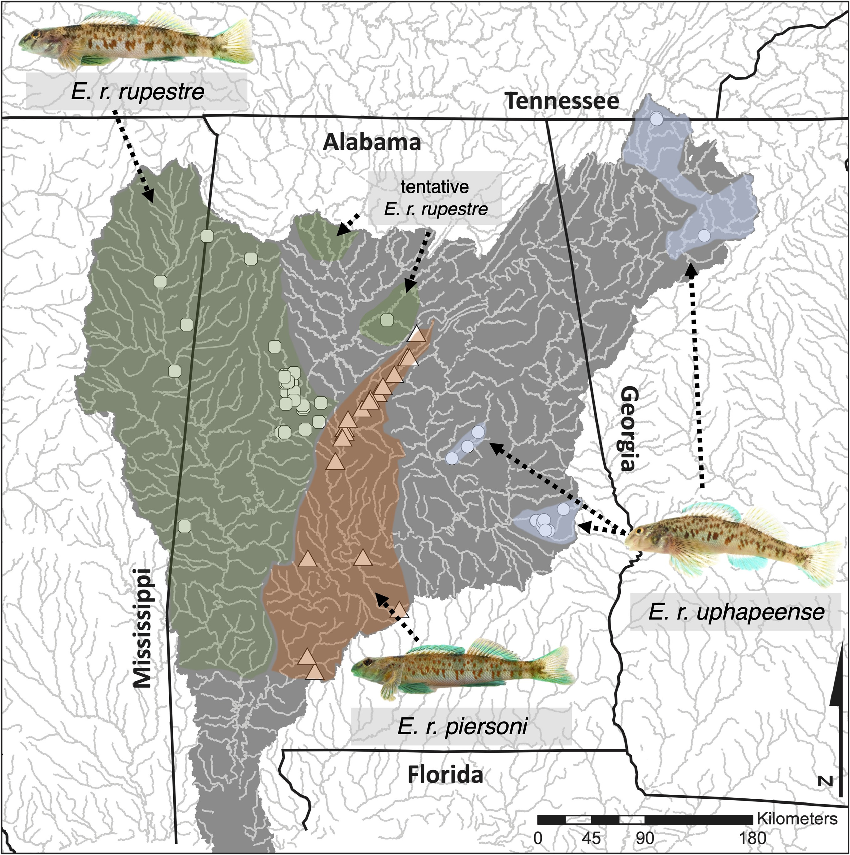
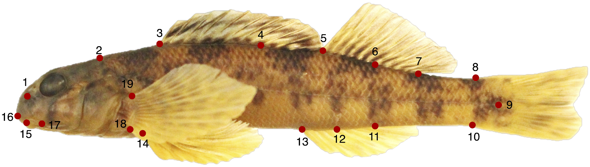
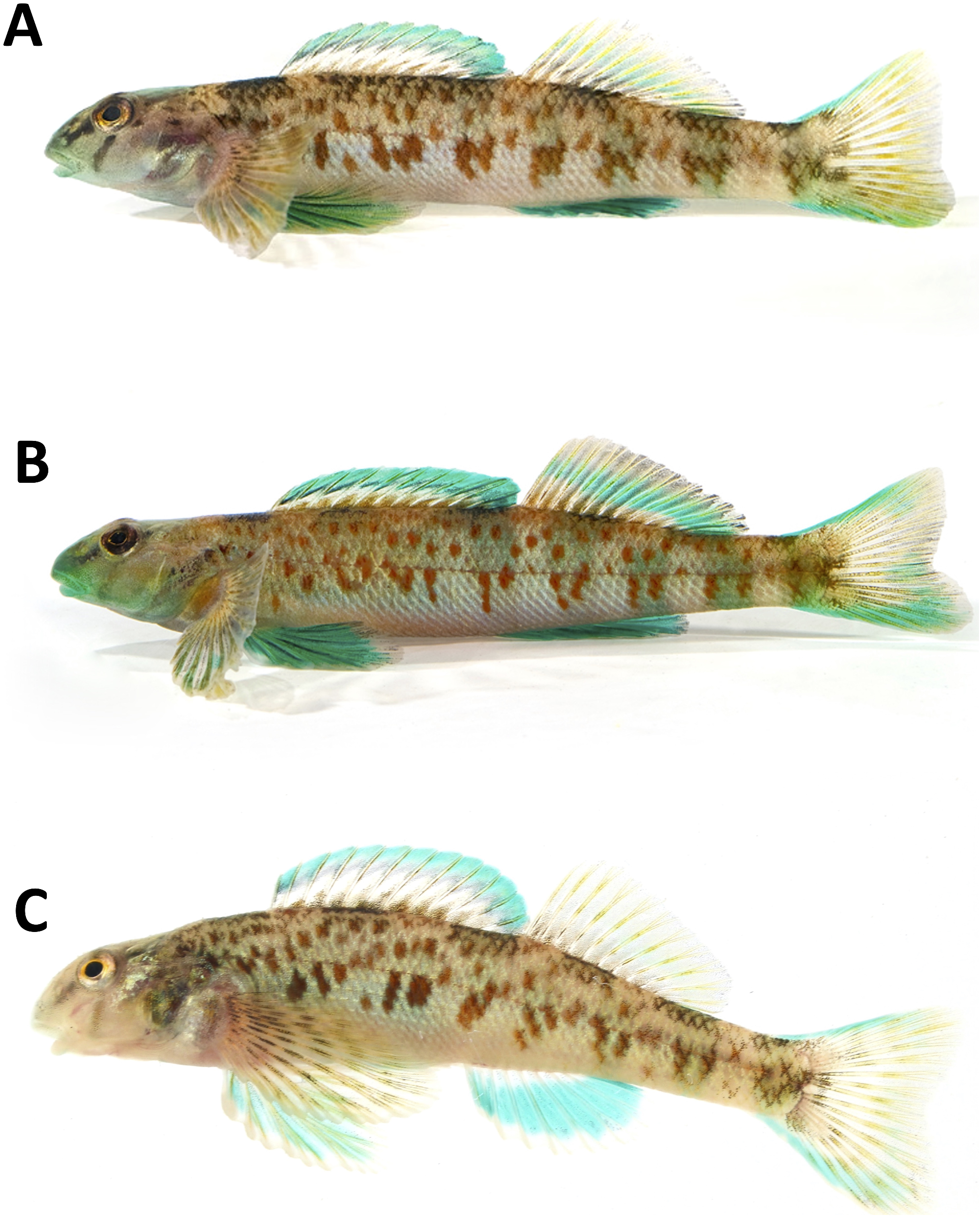
TABLE 10. Means and ranges (parentheses) of widths of lateral blotches and dorsal saddles as well as distances between blotches of the Etheostoma rupestre subspecies. Distances are expressed as percent of standard length.
| BLOTCHES | SADDLES | ||||
|---|---|---|---|---|---|
| Taxon | Mean Dist. Btwn. Blotches (%) | Blotch Width (%) | n | Mean Saddle Width (%) | n |
| E. r. rupestre | 4.8 (3.5–7.5) | 5.5 (4.2–6.6) | 19 | 8.0 (5.8–9.1) | 19 |
| E. r. piersoni | 4.6 (2.8–6.6) | 6.2 (4.6–8.2) | 16 | 7.9 (6.6–8.8) | 17 |
| E. r. uphapeense | 5.0 (4.0–6.1) | 4.6 (3.8–5.3) | 17 | 6.9 (5.7–8.0) | 17 |
| Total | 52 | Total | 53 |
| T |
Tavera, Department of Geology and Geophysics |
No known copyright restrictions apply. See Agosti, D., Egloff, W., 2009. Taxonomic information exchange and copyright: the Plazi approach. BMC Research Notes 2009, 2:53 for further explanation.