
Gomphostemma crinitum Wall.
|
publication ID |
https://doi.org/ 10.1007/s12225-021-09991-y |
|
DOI |
https://doi.org/10.5281/zenodo.7618316 |
|
persistent identifier |
https://treatment.plazi.org/id/2733879D-FFA8-1C33-0C10-90901C85FC4B |
|
treatment provided by |
Valdenar |
|
scientific name |
Gomphostemma crinitum Wall. |
| status |
|
2. Gomphostemma crinitum Wall. View in CoL View at ENA ex 3enth.
(Bentham in Wallich 1830b: 12); Hooker (1883: 698); Prain (1891: 232); Mukercee (1920: 209); Keng (1969: 82, 1958: 321); Murata (1956: 188); Li & Hedge (1992: 52); Phuong (2000: 103); Walsingham (2019: 196). Type: Burma, Tavoy [12.0333°, 98.2], 22 Oct. 1825, Gomez s.n. in Wall. Cat. 2139.2 (lectotype K [K000301083], selected here; isolectotype K-W [K001113328]).
Gomphostemma crinitum var. griffithii Prain (1891: 232) View in CoL . Type: Malaysia, Mt Ophir [Gunung Ledang, 2.3665°, 102.6165°], Chebu [Chabau] forest, Griffith 2022 (lectotype CAL [CAL0000005125], selected here; isolectotypes K [K000229839, K000229820], P).
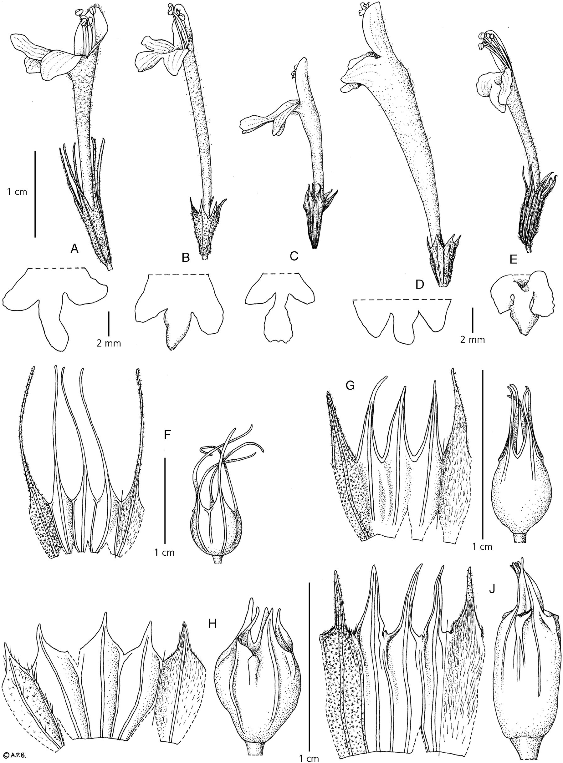
Perennial herb up to 2.3 m tall. Stems erect, woody at base, obtusely quadrangular with longitudinal grooves, with dense stellate hairs and sometimes dendroid hairs. Leaoes petiolate, chartaceous; blades elliptic, elliptic-obovate or elliptic-ovate, 20 – 33 × 6 – 11 (– 12) cm, apex acute, margin shallowly serrate, base attenuate, upper side dark green with sparse stellate hairs, lower side pale green tomentose with dense stellate hairs; petioles 20 – 30 mm long. Inflorescence axillary with opposite cymes, unbranched then congested with axis not visible between flowers or rarely branched, exceeding 20 mm wide when pressed, excluding corolla, inserted at the upper nodes at which leaves are usually present; verticils few – many-flowered; bracts lanceolate or ellipticovate, 13 – 30 × 2 – 3 mm, narrower than the calyx, apex acute, margin entire, base cuneate, upper side with sparse stellate hairs, lower side with dense stellate hairs; bracteoles linear, 10 – 20 × 1 – 3 mm. Flowering calyx tubular, 12 – 13 mm long, 10-ridged, outside with stellate hairs, inside tomentose with adpressed simple hairs; tube 2 – 3 mm long; lobes triangular, 8 – 10 mm long, apex filiform. Fruiting calyx cupular, 13 – 20 mm long; tube 3 – 5 mm long; lobes 10 – 13 mm long. Corolla bright yellow, 20 – 30 mm long, throat narrow, not enlarged, sometimes gradually dilated towards the throat; tube straight, 13 – 23 mm long, exserted from the calyx, outside with stellate hairs, inside glabrous; posterior lip elliptic-ovate, 3 – 5 mm long; anterior lip 3-lobed, longer than posterior lip with median lobe ovate, 3 mm long and lateral lobes ovate, apex round. Staminal filaments slightly fleshy. Style slender, slightly shorter than corolla, glabrous with apex unequally lobed. Nutlets solitary, globose or ovate, 2 – 5 mm long, glabrous. Fig. 6A, F View Fig .
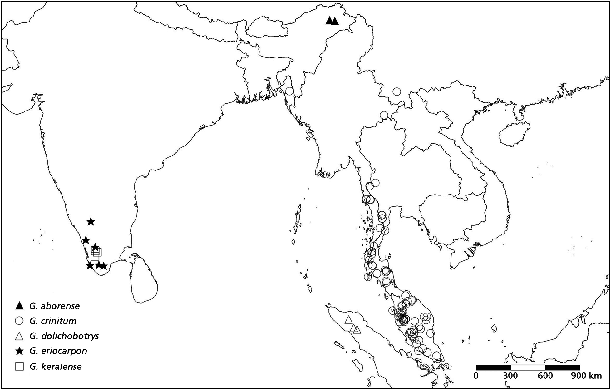
DISTRIBUTION. Bangladesh, China (Yunnan), Burma, Thailand, Peninsular Malaysia, Indonesia (Sumatra). Map 1 View Map 1 .
SPECIMENS EXAMINED. BANGLADESH. Chittagong: Rangamati, Sitapahar, Kaptai [22.3139°, 92.2036°], 8 Oct. 1998, Uddin & Ullah 3338 (AB?). CHINA. Yunnan: Mong-hain or Gan-lan-ba [22.2833°, 100.3833°], Che-li Hsien, 860 m, Oct. 1936, Wang 59803 (KUN). MYANMAR. Tanintharyi: Eastern Tenasserim [11.8°, 99.23°], 30 m, 30 May 1932, Kerr 21612 (BK, BM, K); Tavoy, 22 Oct. 1825, Gomez s.n. in Wall. Cat. 2139.2 (lectotype, K [Herb. Benthamianum]; isolectotypeKW); Tavoy, Zimba Valley, 22 Nov. 1922, Parker 2233 (K); Tenasserim, Tavoy, along the W bank of Paungdaw R., 3 miles E of Paungdaw Power Station, 220 m [800 ft], 22 Aug. 1961, Keenan et al. 1098 (E, K). THAILAND. Chiang Rai: Trail to?oi Jong Summit, 20°35&65”N 98°92&68”E, Nov. 2011, Norsaengsri & Tathana 5351 (QBG); Kanchanaburi: Kwae Noi River Basin, near Neeckey, near Wangka [13.1°, 98.2665°], 130 m, 2 June 1926, den Hoed 912 (BK, K, L, P); Thung Yai Naraesuan Wildlife Sanctuary [13.3333°, 98.9165°], Lai Wo, Ban Saneh Pawng, 200 m, 16 June 1993, Maxwell 93-626 (BKF, CMUB); Phetchaburi: Kaeng Krachan?istr., Kaeng Krachan National Park, on steep slope down from road on the way to Phanoen Thung Ranger Substation, 12°28&N 99°22&E, 360 m, 9 May 2003, Middleton et al. 3323 (BKF, E); Kaeng Krachan, near Ban Krang Camp, 18 th km, 12°28&N 99°26&E, 330 m, 25 June 2000, Newman et al. 1102 (AAU, BKF, E); Prachuap Khiri Khan: Kao Luang [Khao Luang, 11.6°, 99.6665°], 500 m, 2 July 1926, Kerr 10832 (AB?, BK, BM, L); Ranong: Ban Racha Krude, 9°22&N 98°35&E, 30 – 100 m, 5 July 1992, Larsen et al. 23200 (AAU, BKF); Klong Naka Wildlife Sanctuary, stream branch about 200 m down stream from base camp, left branch, flowing from NW, 9°30&N 98°20&E, 100 – 600 m, 9 Jan. 1990, Hoooer et al. 3312 (E); Kraburi [Kra Buri, 10.2°, 98.5833°], Klawng Wa, 30 m, 23?ec. 1928, Kerr 16310 (AB?, BK, BM 2 sheets, L); Muang?istr., Ranong Hot Springs, 9°35&23”N 98°39&11”E, 20 m, 23 June 2006, Williams et al. 2080 (E); Surat Thani: Phanom, Khlong Phanom National Park, ‘Big Tree’ nature trail, S of park headquarters, 8°32&N 98°20&E, 130 m, 26 Nov. 2003, Gardner et al. ST 1952 (E 2 sheets); Phanom, Ban Phong Lom, Khao Mok, Khao Sok National Park [8.8333°, 98.5°], 30 – 130 m, 29 Aug. 1982, Shimizu et al. T-28921 (BKF); Takuapah, Takuapah-Surat Thani Road, 20 – 60 km from Takuapah, 8°33&N 98°21&E, 100 – 230 m, 12 July 1952, Larsen et al. 30928 (AAU, BKF, K, L); Phangnga: Khao Khlong Yang at Khao Phra Mi, 9°15&N 98°26&E, 100 – 300 m, 6 July 1952, Larsen et al. 30632 (AAU, BKF, K, L, P); Krabi: Tambon Kao Panom [8.23°, 99.0333°], 100 m, 1 April 1930, Kerr 18802 (BK, BM 2 sheets); Nakhon Si Thammarat: Kao Luang [8.3°, 99.6665°], 200 m, 28 April 1928, Kerr 13222 (BK, BM 2 sheets); Lansaka, Kiriwong [8.2333°, 99.5833°], 25 Jan. 1931, Smitinand s.n. (BKF); Trang: Kao Chong, 5°20&N 99°23&E, 200 m, 13 June 1952, Geesink et al. 5165 (AAU, BKF, K, L); Nayong, Khao Chong, trail from botanic garden headquarters to Ton Yai, 5°33&N 99°25&E, 80 m, 9 July 2000, Middleton et al. 362 (BKF); Pattani: Betong [3.53°, 101.0333°], 300 m, 3 Aug. 1923, Kerr 5280 (BK, BM, K, L); Yala. Betong, Bang Lang National Park, Ban Chulaphon Phattana 10, near rattan plantation procect, 3°31&N 101°18&E, 600 m, 19 July 2002, Pooma et al. 2225 (BKF); Nikom Kua Long, 600 m, 12 Feb. 1952, Santisuk & Nimanong 355 (BKF); Than To, Bang Lang National Park, along stream to Halasa Waterfall, 6°02&N 101°3&E, 133 m, 12 Feb. 2002, Middleton et al. 3000 (BKF, E); Narathiwat: Bukit [6.1665°, 101.8333°], 200 m, 8 July 1923, Kerr 5119 (BK, BM, K). MALAYSIA. Johor: Bukit Jitan [2.0665°, 102.9833°], Nov. 1900, Ridley 11131 (SING); Woods below Mt Ophir [2.3665°, 102.6165°], June 1892, Ridley s.n. (SING); Mt Ophir [Gunung Ledang, 2.3665°, 102.6165°], Chebu [Chabau] forest, Griffith 2022 [type of G. crinitum var. griffithii , lectotype CAL; isolectotypes K 2 sheets, P]; Sungai Linggiu logged forest via Kluang [1.8139°, 103.6922°], 130 m, 23 July 1991, Tay et al. 91-33 (SING); Kedah. Kedah, Kroh [3.5°, 100.9833°], 120 m [200 ft], 6 Aug. 1921, Nauen 38026 (K 2 sheets, GH, SING); Malacca: [2.2°, 102.2833°], Aloins 2130 (SING); Negeri Sembilan: Pasoh Forest [3.0333°, 102.3333°], 18 April 1958, Ang FRI 25353 (GH, L); Bukit Linggung, Ulu Bendol [2.5333°, 102.1333°], 1?ec. 1922, Holttum 9836 (SING); Genting Peras [3.1333°, 101.9665°], May, Ridley 5600 (SING); Kelantan: Aring FR, Anthonysamy SA 1092 (KEP); Pahang: Bentong, Genting Sempah [3.3333°, 101.9165°], 353 m [1230 ft], 18 Jan. 1939, Wyatt-Smith 93193 (K, L); Bukit Sadam [Bukit Serdam, 3.8333°, 101.9165°], 120 m [200 ft], 6 Oct. 1931, Henderson 23061 (BK, BM, SING); Kuala Tembeling [2.0665°, 102.3165°], 20 Aug. 1928, Holttum 20331 (SING); Kwala Jahau, Aug. 1891, Ridley 2183 (K); Pulau Manis [3.33°, 103.2165°], 1891, Ridley s.n. (SING); Ulu Sungai, Sepia [2.6108°, 102.8839°], Jeram Perahu, 130 m [300 ft], 18 July 1950, Shah & Noor 1963 (C, GH, L, SING); Sungai Yu [2.3008°, 102.0028°], 1 Feb. 1922, Nur & Forworthy 11922 (SING); Penang [3.3333°, 100.23°], 1822, Wall. Cat. 2139.1 [lectoparatypes of G. crinitum , K-W]; ibid., Wall. Cat. s.n. (K); ibid., Wall. Cat. 2138C (K-W); Perak [3°, 101°], 300 m, July 1889, Wray 3553 (SING); Kampong Kota [2.2665°, 100.8°], Feb. 1889, Wray 3320 (SING); Batu Tegoh, Taiping [2.83°, 100.5333°], 19 Jan. 1922, Henderson 10038 (SING); Gunung Icok [3.2°, 100.5165°], Sept. 1882, Scortechini 3 (lectoparatype of G. crinitum var. griffithii, CAL ); Gopeng [2.2665°, 101.1665°], S of Ipoh, Gua Kandu, Daoison 1 (SING); Gunong Kerbau [Korbu] [2.6833°, 101.3°], 1200 – 1330 m [2000 – 2300 ft], 12 March 1913, Robinson s.n. (BM); Gunong Raya [Korbu, 2.6833°, 101.2833°], 1200 m [2000 ft], 31 Jan. 1938, Strugnell 23832 (K); Hulu Kwansa [Kangsar], June 1882, Scortechini 928 (lectoparatypes CAL, SING); Hulu Perak, Lenggong, Lata Kekabu, along trail in recreational forest, after hanging bridge, 3°2.93&N 100°92.32&E, 151 m, 18?ec. 2006, Lim et al. FRI 32830 (K, SING); Ipoh, near Rapat [2.3665°, 101.1165°], mouth of limestone caves, 600 m [2000 ft], 12 Jan. 1983, Daois 69298 (E); Kamuning [2.8333°, 101.0665°], Feb. 1902, Ridley s.n. (SING); Larut & Matang, Bukit Larut Forest Reserve [2.83°, 100.5833°], 310 m, 13 Aug. 1999, Saw FRI 22282 (K); Tancung Rambutan [2.6665°, 101.1665°], 2 June 1930, Henderson 23553 (SING); Tambun limestone cliffs, 10 Sept. 1920, 3urkill & Haniff 6298 (K, SING); Tong Temple, Chemor [2.5165°, 101.1165°], 2 miles N of Ipoh, base of limestone rocks, 23 Oct. 1938, Sinclair 9829 (E, GH, K, L, SING); Upper Perak, N of Lawin, S Kenerong [3.2665°, 101.03°], 20 June 1922, 3urkill 12282 (SING); Upper Perak, Bintang Hicau Forest Reserve, Compartment 22, [3.2333°, 100.9665°], 22 Nov. 1966, Ismail 99812 (GH, K, L, SING); Selangor. Hulu Selangor, Gading Forest Reserve [3.6665°, 101.6333°], 230 m [1300 ft], 19 July 1969, Loh 13368 (K, L); 3 miles before Gap [3.6350°, 101.5359°] from Kuala Kubu Baru, 16 March 1983, Kiew 1629 (SING); Genting Bidai [3.3°, 101.8165°], Kloss s.n. (BM, K); Genting Sempah [3.33°, 101.5833°], 22 Oct. 1921, Hume 9263 (SING); Ulu Selangor [3.3665°, 101.3665°], 8 Oct. 1899, Goodenough s.n. (SING); Terengganu. Ulu Brang [2.83°, 102.9333°], 120 m [200 ft], July 1935, Moysey & Kiah 33503 (SING); Hulu Terengganu, Tasik Kenyir, Ex logging trail from Tancung Bewah towards Gunung Taat, 2°30.52&N 102°22.95&E, 282 m, 5 Aug. 2005, Lim et al. FRI 36261 (K, SING). INDONESIA. SUMATRA. Riau: Indragiri, Pangian, Indragiri Kwantan?istr., 1 Oct. 1939, 3uwalda 6238 (GH, K).
HABITAT. In primary or secondary, lowland dipterocarp forest, evergreen forest, on riverbanks; alt. 23 – 1330 m.
CONSERVATION STATUS. Widespread; Least Concern (LC).
PHENOLOGY. Flowering April – October. Fruiting September – March.
NOTES. Gomphostemma crinitum is recognised by filiform fruiting calyx lobes, much longer than the tube at maturity. It is morphologically similar to G. paroiflorum in having a straight corolla and narrow corolla throat, but G. paroiflorum does not have calyx lobes longer than the tube.
Prain named Gomphostemma crinitum var. griffthii based on some specimens from Peninsular Malaysia distinguished by their leaf blades, petiole and calyx; we consider them to fall within the variation in these characters in G. crinitum . Gomphostemma crinitum var. griffithii was named to honour William Griffith, a British colonial physician and botanist in 1891 when Prain acted as Superintendent of the Calcutta Botanic Garden, Calcutta: Griffith’ s collection (Griffith 2022, C [CAL0000005125]) is selected as the lectotype.
No known copyright restrictions apply. See Agosti, D., Egloff, W., 2009. Taxonomic information exchange and copyright: the Plazi approach. BMC Research Notes 2009, 2:53 for further explanation.
|
Kingdom |
|
|
Phylum |
|
|
Class |
|
|
Order |
|
|
Family |
|
|
Genus |
Gomphostemma crinitum Wall.
| Bongcheewin, Bhanubong, Ingrouille, Martin J. & Paton, Alan J. 2022 |
Gomphostemma crinitum var. griffithii
| Prain 1891: 232 |