
Hibiscus laurinus Baill.
|
publication ID |
https://doi.org/ 10.15553/c2020v752a4 |
|
DOI |
https://doi.org/10.5281/zenodo.5708687 |
|
persistent identifier |
https://treatment.plazi.org/id/190687BC-5A7D-447C-A235-64ADF18364BD |
|
treatment provided by |
Carolina |
|
scientific name |
Hibiscus laurinus Baill. |
| status |
|
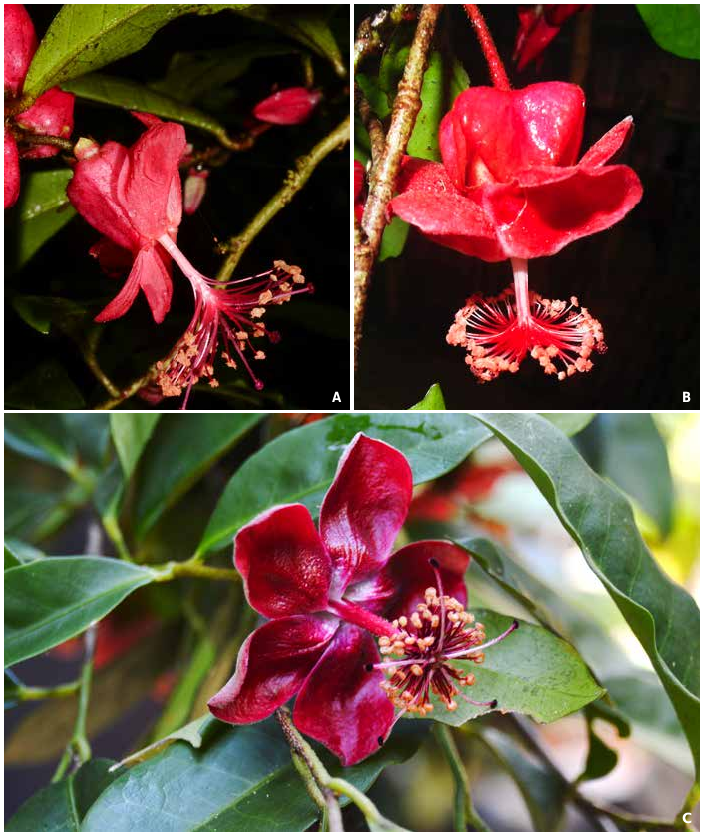
Hibiscus laurinus Baill. View in CoL in Bull. Soc. Linn. Paris 1: 512: 1885 ( Fig. 1B View Fig ).
Macrostelia laurina (Baill.) Hochr. & Humbert View in CoL in Hochr., Fl. Madagascar Comores 129: 120. 1955.
Lectotypus (designated here): MADAGASCAR. Reg. Alaotra-Mangoro [Prov. Toamasina]: “ Manahar ”, [NE of Lac Aloatra], 12.V.1882, fl., Humblot 241 ( P [ P00037128 ]!; iso-: G [ G00017097 , G00017098 ]!, K [ K000240701 ] image seen, P [ P00037129 , P00365086 ]!) .
= Humbertianthus cardiostegius Hochr. View in CoL in Bull. Mus. Natl. Hist. Nat. 20: 476. 1948. Lectotypus (designated here): MADAGASCAR. Reg. Atsinanana [Prov. Toamasina]: Betampona RNI, 19.I.1937, fl., Réserves Naturelles 74 (P [ P00037130 ]!; iso-: G [ G00014468 ]!, MO-6089629!, P [ P0037131 , P00389395 ]!, TAN), syn. nov.
Vernacular names. – “Hafotra Fotsy” (Réserves Naturelles 74); “Ombavy” (Réserves Natuelles 108, Lehavana 243); “Tanatanapotry” (Réserves Naturelles 2484).
Distribution and ecology. – Hibiscus laurinus has the widest distribution of all the east coast pendent Hibiscus species. H . laurinus is known from low elevation, moist evergreen forest northwest of Toamasina in the protected area of Betampona to west of Bemanevika in the forests of Makirovana and Farahanitra in the north ( Fig. 2 View Fig ). Hibiscus laurinus grows from 100 to 1329 m in elevation.
Conservation status. – Hibiscus laurinus is relatively widespread in Madagascar and has a geographic range in the form of an extent of occurrence (EOO) of c. 10,248 km ² and an area of occupancy (AOO) of 60 km ². It occurs in the protected areas of Betampona, Makirovana Tsihomanaomby, and Masoala, and is found at a minimum of 15 locations. This species is therefore assessed as “Least Concern” [LC] using the IUCN Red List Categories and Criteria ( IUCN, 2012).
Notes. – Humbertianthus cardiostegius and Hibiscus laurinus were both described as small, slender trees with entire, elliptic, reticulate to pinnately-veined, briefly petiolate leaves with similar leaf sizes (4– 8 × 2.5– 4 cm). All collections of Humbertianthus cardiostegius are limited to January and March, whereas Hibiscus laurinus has been collected in flower from March through October. Pedicels on both entities are covered with ferrigenous hairs. The buds of H. laurinus resemble those of Humbertianthus cardiostegius . Perianth descriptions of H. cardiostegius have smaller proportional measurements than Hibiscus laurinus ; shorter sepals, 10 mm (vs 3 cm) and shorter petals, 5 mm (vs 4–5 cm). The convergent nature of the stigmas in Humbertianthus cardiostegius , as well as the extremely “reduced” staminal column appear to represent reproductive organs that have yet to differentiate and elongate. The stigmas in both taxa have very long, hairy style branches. The abaxial portions of petals in both taxa are covered in a coarse pubescence. Flowers of Hibiscus laurinus are a vibrant red whereas those of Humbertianthus cardiostegius have been noted in the literature to be white or pink. The first author visited Betampona in January 2005 and collected Hibiscus laurinus in bud (Koopman 224) which ranged in color from white to a brilliant red. Fruits from Humbertianthus cardiostegius were never described, though 2– 3 ovules in 5 locules within a hirsute ovary have been described, these values are consistent with Hibiscus laurinus .
Three type collections of both Humbertianthus cardiostegius and Hibiscus laurinus are extant at P (respectively Réserves Naturelles 74 and Humblot 241). The most complete collections of each of the two names are designated here as lectotypes.
Additional specimens examined. – MADAGASCAR. Reg. Analanjirofo [Prov. Toamasina]: Maroansetra, Anjahana , Ambanizana , 15°37'16"S 49°58'56"E, 200 m, 15.IX.2002, fl., Antilahimena 1397 ( MO, P) GoogleMaps ; Mahalevona, 15°25'27"S 49°57'05"E, 975 m, 11.X.2003, fl., Antilahimena 2187 ( G, MO, P) GoogleMaps ; Ambanizana, Masoala NP, 15°37'35"S 49°58'37"E, 249 m, 21.X.2004, fl., Antilahimena 2920 ( MO, P) GoogleMaps ; c. 6 km NE d’Ambanizana, 600–700 m, 24.I.1996, fr., Aridy 54 ( MO, P, TAN) ; trail E of village of Hiaraka, toward the rock, ESE of Maroantsetra, 15°29'S 49°55'E, 275 m, 9.X.1986, fl., Lowry 4028 ( MO) GoogleMaps ; presqu’île de Masoala , 15°38'S 49°58'E, 100 m, 9.XI.1994, fr., Rabe 192 ( MO, P, TAN) GoogleMaps ; Ambanizana , 15°34'27"S 50°00'35"E, 1000 m, 24.VII.2000, bud, fl., Rabenantoandro 229 ( G, MO, P, TAN) GoogleMaps ; Vohimarangitra , 20. I.1950, bud & fl., Réserves Naturelles 2484 ( P) ; Masoala Peninsula, Androanabe , 15°39'30"S 49°57'30"E, 0–600 m, 1.III.1992, fr., Zjhara & Hutcheon 186 ( MO, P) GoogleMaps ; Masoala Peninsula, Androanabe , 15°39'30"S 49°57'30"E, 0–600 m, VI –VII.1993, Zjhara & Hutcheon 357 ( G, MO, P) GoogleMaps . Reg. Atsinanana [Prov. Toamasina]: Ambodiriana, Andratambe , 17°54'32"S 49°12'09"E, 469 m, 27.III.2009, fl. & fr., Andriamiarinoro 186 ( P) GoogleMaps ; RNI Betampona , 210–410 m, 24.IV.1994, fl., Andrianarisata 118 ( MO, P) ; 3 km NW of Fotsimavo, camp at Rendrirendry, Betampona RNI, 17°55'49"S 49°12'12"E, 350 m, 19–26.III.1999, fl., Birkinshaw 567 ( MO, P, TAN) GoogleMaps , ibid. loco, 28.III.1941, fl., Decary 16913 ( P) GoogleMaps ; ibid. loco, 23km NW Fotsimavo , 17°55'41"S 49°12'11"E, 1329 m, 13. I.2005, bud, Koopman 224 ( MO, P, TAN, WIS) GoogleMaps ; ibid. loco, 17°54'56"S 49°12'16"E, 466 m, 29. I.2005, bud, Lehavana et al. 243 ( MO, P) GoogleMaps ; ibid. loco, 17°55'15"S 49°12'01"E, 489 m, 8.III.2007, bud, fl., Rakotoarivelo 36 ( MO, P) GoogleMaps ; Marovato, forêt d’Agnalahely , 17°53'13"S 49°14'13"E, 288 m, 5.III.2017, fl., Rakotoarivelo 83 ( K, MO, TAN) GoogleMaps ; Belalimaitso, forêt de Menagisy , 17°55'25"S 49°19'41"E, 86 m, 11.III.2018, fl., Rakotonirina 422 ( MO, TAN) GoogleMaps ; Fkt. d’Ampasina, Ampasimazava, forêt d’Amparafaravay , 17°56'27"S 49°20'09"E, 180 m, 12.III.2018, fl., Rakotonirina 437 ( K, MO, TAN) GoogleMaps ; Fkt. d’Ampasina, forêt d’Alahambana , 17°54'49"S 49°19' 05"E, 167 m, 12.III.2018, fl., Rakotonirina 445 ( MO, TAN) GoogleMaps ; Fkt. d’Analamangahazo, village de Marovato, forêt d’Andriambôla , 17°53'05"S 49°13'54"E, 275 m, 9.III.2017, fl., Rasoandriana 89 ( K, MO, P, TAN) GoogleMaps ; Betampona , I.1937, bud, Réserves Naturelles 108 ( G, P) ; ibid. loco, 17°55'S 49°13'E, 500 m, 5.IV.1989, fl., Schatz 2684 ( MO, P) GoogleMaps . Reg. SAVA [Prov. Antsiranana]: massif de Makirovana , 14°10'35"S 49°56'09"E, 546 m, 22.VIII.2007, fr., Andriamihajarivo 1258 ( MO, P) GoogleMaps ; Antsahanivo-Ambodivapaza, forêt de Farahanitra , 14°09'16"S 49°55'26"E, 534 m, 13.VII.2013, fl. & fr., Martial et al. 174 ( MO, P) GoogleMaps ; Makirovana , 14°10'00"S 49°57'01"E, 22. V.2009, bud & fl., Raharimampionona 250 ( MO, P, TAN, TEF) GoogleMaps ; ibid. loco, 14°10'23"S 49°57'27"E, 324 m, 24. V.2009, fl., Razakamalala 4346 ( MO, P, TAN) GoogleMaps ; ibid. loco, 14°09'50"S 49°57'09"E, 764 m, 6. V.2010, bud, Razakamalala 5499 ( MO, P, TAN) GoogleMaps ; Antalaha-CR Vinanivao, CAP Masoala haute-vallée d’Anaovanandrano , 15°40'S 50°03'E, 390 m, 24.IX.2003, fl., Wohlhauser et al. 634 ( G, P) GoogleMaps .

| WIS |
WIS |
| TEF |
TEF |
| P |
Museum National d' Histoire Naturelle, Paris (MNHN) - Vascular Plants |
| G |
Conservatoire et Jardin botaniques de la Ville de Genève |
| K |
Royal Botanic Gardens |
| MO |
Missouri Botanical Garden |
| TAN |
Parc de Tsimbazaza |
| I |
"Alexandru Ioan Cuza" University |
| VI |
Mykotektet, National Veterinary Institute |
| WIS |
University of Wisconsin |
| V |
Royal British Columbia Museum - Herbarium |
| TEF |
Centre National de la Recherche Appliquée au Developement Rural |
No known copyright restrictions apply. See Agosti, D., Egloff, W., 2009. Taxonomic information exchange and copyright: the Plazi approach. BMC Research Notes 2009, 2:53 for further explanation.
|
Kingdom |
|
|
Phylum |
|
|
Class |
|
|
Order |
|
|
Family |
|
|
Genus |
Hibiscus laurinus Baill.
| Hanes, Margaret M., Schatz, George E. & Callmander, Martin W. 2020 |
Humbertianthus cardiostegius
| Hochr. 1948: 476 |
Hibiscus laurinus
| Baill. 1955: 120 |
| Baill 1885: 512 |