
Astragalus palmeri A. Gray
|
publication ID |
https://doi.org/ 10.11646/phytotaxa.586.1.1 |
|
DOI |
https://doi.org/10.5281/zenodo.7713517 |
|
persistent identifier |
https://treatment.plazi.org/id/0D132D31-FFEE-5F5B-B6AE-ACC6FBB92C7C |
|
treatment provided by |
Plazi |
|
scientific name |
Astragalus palmeri A. Gray |
| status |
|
67. Astragalus palmeri A. Gray View in CoL , Proc. Amer. Acad. 7: 398. 1868
Type: — USA, Arizona, Camp Grant , in southern Arizona, 22 April 1867, E. Palmer 52 (holotype: GH00058860 distial image!; isotype: MO- 149234 distial image!).
Tragacantha palmeri Kuntze, Revis. Gen. Pl. View in CoL 2: 947. 1891; Phaca palmeri (S. Watson) Rydb., N. Amer. Fl. 24: 354. 1929
Astragalus vaseyi S. Watson, Proc. Amer. Acad. Arts View in CoL 17: 370. 1881 –82. — Phaca vaseyi (Vasey) Rydb., N. Amer. Fl. 24(6): 354. 1929.
Astragalus metanus M. E. Jones, Proc. Calif. Acad. Sci. View in CoL ser. 2, 5: 666. 1895. — Phaca metana (M. E. Jones) Rydb., N. Amer. Fl. 24(6): 354. 1929. — Astragalus vaseyi S. Watson var. metanus (M. E. Jones) Munz & McBurney, Bull. S. Calif. Acad. View in CoL 31: 66. 1932.
Perennial. Stems up to 50 cm long, diffuse, sparsed and only with the distal parts ascendant, minute strigose, the trichomes up to 0.6 mm long, mainly appressed, sometimes with some few longer straight or sinuous ones, green or ashen color. Stipules 1.5–6.5 mm long, semi-clasping and decurrent, not connate. Leaves 3–16 cm long, leaflets 11– 21, 2–26 mm long, oblong, elliptic to ovate or obovate, distally acute, obtuse and mucronate, rarely retuse, pubescent in both faces, adaxially denser, rarely, abaxially with the midvein prominent. Peduncles 4–14 cm long, ascending or curved; the racemes 3–21 cm long, flowers 10–40. Flowers purple to rose-shiny, the banner striate in the area where it folds, rarely apically whitish or with purple veins; the calyx 3.6–6.6 × 1.8–3.4 mm, minute strigose, the trichomes white, black or both, mixed, the tube 2.2–3.8 mm long, campanulate or somewhat ovoid, sometimes with purple tones, the teeth 0.9–2.8 mm long, subulate to triangular, the ventral pair the wider; the banner 7–10.4 × 5.2–8 mm, recurved; the wings 6.3–9.4 × 1.7–3.2 mm, the claw 2.8–3.8 mm long, the blade 4.5–6.2 mm long, oblong or oblanceolate to oblique obovate, strongly incurved; the keel 6.1–8.9 × 2–2.6 mm, the claw 2.5–3.7 mm long, the blade, 4.1–5.5 mm long, lunate, distally acute. Pod 0.9–2.3 x 0.4–1.7 cm, sessile, ascendant to pendulous, oblique, ovoid to elliptic and acuminate, moderate or markedly inflated, basally rounded or widely cuneate, distally contracted in a straight to incurved, a third or less of its length beak, lateral faces slightly compressed, sutures narrow, not strongly prominent, straight or little convex, dorsally pronounced, ventrally less pronounced, laterally inflated and rounded, the valves strigose, pale green or with purple tones, ochre, papery, opaque, septum absent; ovules 7–31; seeds 2–3 mm long, mitten shaped, orange, brown, somewhat rugose.
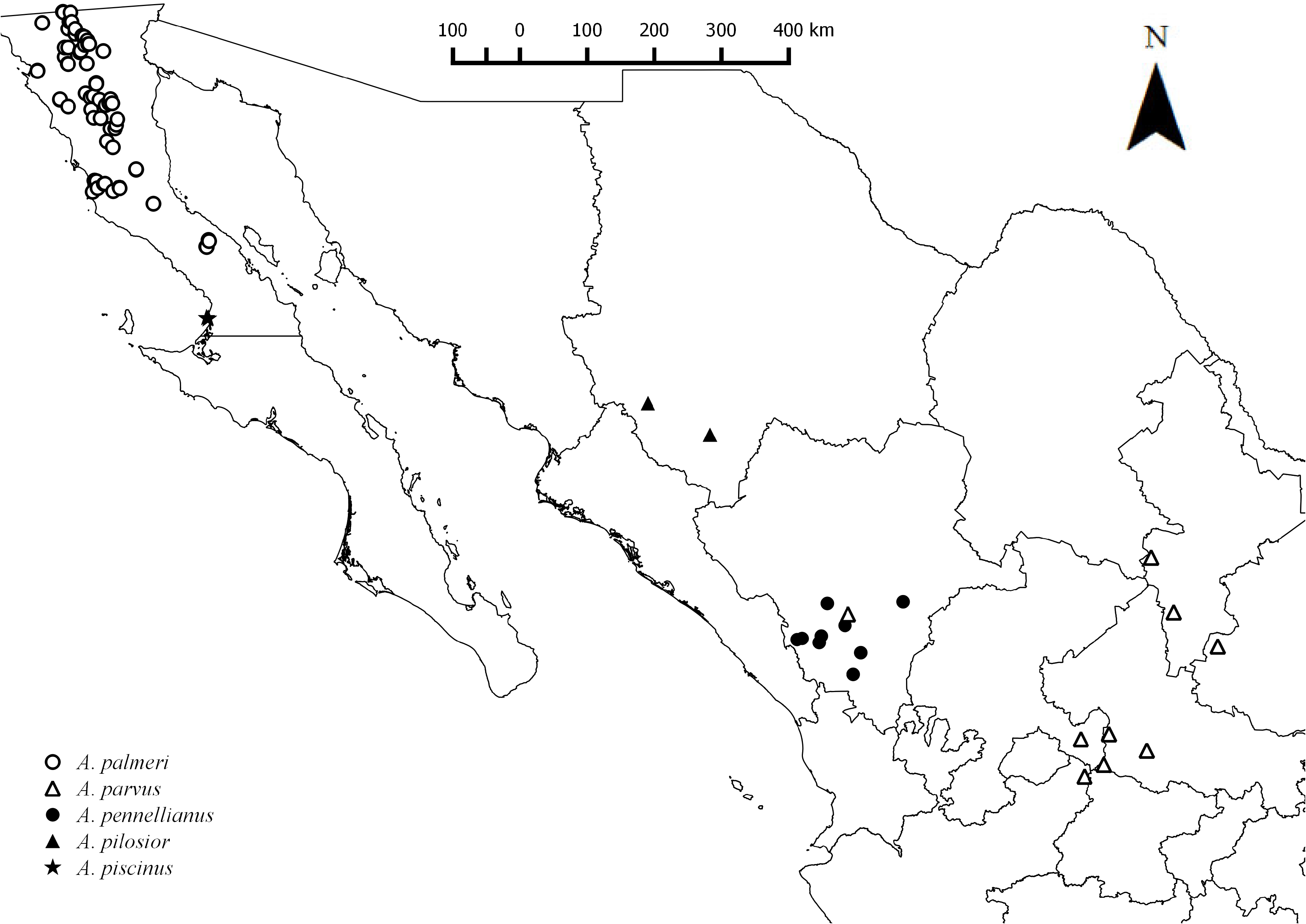
Distribution:— Endemic to the Peninsula of Baja California, distributed in the lower and higher elevation portions of the Sierras Juárez and San Pedro Mártir. Also, in Arizona and California ( USA) ( Fig. 21 View FIGURE 21 ).
Habitat:— Sandy, gravel, granite soils; stony slopes; along streams; riparian areas; alluvial fans bordered by slopes with volcanic soil; pine - juniper forests; pine forest; high oak forests; chaparral; areas with chaparral- Quercus ; also associated with mezquite, acacia, prickly-pear, columnar cacti,cirio; 60–1850 m.
Comments:— Two sierras, Juárez and San Pedro Mártir together harbor 18 species of Astragalus . By excluding those with red ochroleucous or completely white flowers, and 8 mm long or shorter, sessile and not inflated bladderlike pods, there are a group of four closely related species, A. gruinus , A. hornii var. minutiflorus , A. proriferus and A. palmeri
Of these, A. hornii is recognized by its oblong or compact, globose racemes, most commonly inhabiting cemented saline terraces, adjacent to coastal dunes. Astragalus gruinus , A. proriferus , and A. palmeri converge only in San Pedro Mártir, occurring together in oak-pine and pine forest at 1600–3000 m. Astragalus grunius has pods (9–28 mm long) strongly attached to the receptacle, when maturing and falling, they do together with the pedicels, while A. proriferus and A. palmeri have persistent pedicels and the pods are easily and soon caducous, this later species also occur at lower altitudes, 1650 m or below, associated with scrubs bordering the mountain range.
Specimens examined:— BAJA CALIFORNIA: 4 June 1998, California. 10 millas al E de Ojos Negros; 2.2 millas N de la autopista 3 y 0.8 millas de la carretera a Laguna Hanson, J. Rebman 5323, S. Villarreal ( BCMEX, SD) ; 8 February1981, San Telmo, M. Nuñez s.n. ( NY) ; 30 June 1962, Rancho Santa Isabel , Sierra Juarez, R. Moran 9833 ( ENCB, NY, SD) ; 8 May 1963, Sierra San Pedro Mártir. 2 miles E. of Rancho San Rafael, R. Moran 10934 ( NY, SD) ; 2 May 1973, Tinajas de Moraga, S. E. base of Cerro Matomí, R. Moran 20701 ( NY, SD) ; 3 May 1973, On NE slope of Cerro Matomí, R. Moran 20783 ( MEXU, NY) ; 2 June 1975, San Isidoro, R. Moran 22306 ( NY, SD) ; 1 May 1976, Sierra Juárez. Upper Cañada Taraizo. Seen to 1400 m., R. Moran 22973 ( NY, SD, TEX-LL) ; 6 May 1978, Sierra San Pedro Mártir. Cañon del Diablo. Seen at 750 m., R. Moran 25635 ( NY) ; 8 April 1979, Cañon San Matias , 8.0 km al este de San Matias, R. Moran 26953 ( CAS, ENCB, SD) ; 16 November 1980, Santa Lucia, mouth of Cañon San Carlos. Waifs far west of and below usual range, R. Moran 29459 ( ENCB, NY, SD) ; 9 March 1991, San Matias Pass , 29.5 miles west-northwest of Mexico Hwy. 5 on Hwy. 3, T. R., R. K. Van Devender 91-143, T. L. Burgess, R. J. Rondeau, J. Wiens ( NY) ; 12 November 1983, 10 mi S of La Rumorosa, Sierra de Juarez , & ca. 3 mi S of Chi Chi de la India, R. F. Thorne 57460, W. Wisura ( NY) ; 18–19 February1984, Granitic slopes of Canon de Guadalupe, R. F. Thorne 57797, W. Wisura, A. Romsport ( NY) ; 12 May 1991, 1.8 miles north of km marker 110 of Rte. 3 on the road to Ejido Jamau, J. Rebman 1118, K. Rice ( NY) ; 13 March 1992, Approximately 7 miles south of La Rumarosa which is on highway 2 between Tecate and Mexicali, J. Rebman 1274, P. Cordoba ( NY, SD) ; 12 May 1984, Ca. 12.8 mi NE of Meling Ranch, D. J. Pinkava, 14184, M. Mohlenbrock, L. A. McGill ( NY) ; 18 March 1936, Ca. 12.8 mi NE of Meling Ranch, C. F. Harbison 14982 ( CAS, NY) ; 21 February1933, Box Canyon, C. Epling s.n., M. Darsie ( CAS, NY, US) ; 18 April 1985, Rancho La Choya : Chaparral, near Rancho, ca. 2.4 mi NE of Hwy 3 on alternate route to Laguna Hanson, R. F. Thorne 60066, D. Charlton ( ENCB, MEXU, NY) ; 13 May 1941, Arroyo L’agua Marga, southern Sierra San Pedro Martir, I. L. Wiggins 9947 ( CAS) ; 29 April 1963, San Agustin, H. S. Gentry 19969 ( US) ; 27 March 1954, 1.8 miles e. of Alaska, road from Tijuana to Maexicali, G. B. Ownbey 2072 ( US) ; 13 March 1987, Cañon el Carrizo, D. Clemons, E. Jonsson 1638 ( SD) ; 15 April 2000, Área de Rancho Los Martires : a lo largo del área del río, J. Rebman 6467, M. Simpson, A. Russell, D. Burton ( SD) ; 18 April 1984, Cañón de Guadalupe, lava sobre el cañón, A. Romspert s.n. ( SD) ; 16 April 2013, Valle de Tranquilo , arroyo 1/ 2 km arriba Arroyo Rama 2, J. Riley 100, B. Roldán ( SD) ; 16 April 2013, Reserva Natural de Valle Tranquilo : entre San Quintín y El Rosario; en Arroyo Rama, que es un afluente de Arroyo Hondo, aproximadamente a 5 millas al este de Mex. Carretera 1, J. Rebman 25918, J. Riley, B. Roldán ( SD) ; 29 March 2013, Sierra Juárez Norte de Sierra Juárez. camino a 1 km al E del Rancho Club Hacienda. S 20, A. Medel Narváez 2013- 040 ( SD) ; 28 May 1983, Laguna Hanson , Parque Nacional Constitución, Sierra de Juárez, extremo norte del lago en el delta del pantano arenoso y márgenes húmedos del lago, R. F. Thorne 55815, W. Wisura, W. Steinmetz et al. ( SD) 5 April 2005, Sierra La Asemblea : Carretera cerca de El Crucero, 1.0–1.5 millas (1.6–2.4 km) de Mx Highway 1., S. J. DeGroot 4900 ( SD) ; 27 April 2015, Vecindad de la montaña de gabro llamada Cerro El Tecolote: al sur de Mex. Autopista 3 en el Valle de la Trinidad; justo al sur del general Leondro Valle; a lo largo de un sendero en un área del cañón, J. Rebman 30033, S. Vanderplank, W. Schmidtmann ( SD) ; 2 July 1978, 3.0 km al este de El Milagro , al noroeste de Valle Trinidad, R. Moran 26171, J. Reveal ( SD) ; 20 April 1980, 4.0 km al norte de La Huerta, R. Moran 28310 ( SD) ; 18 September 1971, Sierra Juárez ; en la cama de Arroyo los Chivos, 3.0 millas al norte de Rancho Casa Verde, R. Moran 18502 ( SD) ; 20 January 2015, Arroyo Rama ; Reserva Natural Valle Tranquilo, J. Riley 211, J. Campos, J. Simancas, E. Meyer, S. Still ( SD) ; 21 January 2015, Arroyo El Rosario ; justo al este de Carretera, J. Riley 214, N. Jensen, J. Campos, J. Simancas E. Meyer, S. Still ( SD) ; 2 March 2016, Arroyo Portrero afluente de Arroyo El Rosario, J. Riley 411, S. Alfaro ( SD) ; 10 April 1982, Los Alamitos , 6.0 km al noreste de San Vicente, R. Moran 30321 ( SD) ; 11 April 1983, Cañón la Calentura , 1.5 km west of Los Pinos, R. Moran 30387 ( SD) ; 29 May 1982, 4.0 km al este y noreste de Jacumé, R. Moran ( SD) ; 30 May 1982, Sierra Juárez ; Rancho San Francisco, 6.0 km al sur de La Rumorosa, R. Moran 30820 ( SD) ; 10 March 1987, Tajo Canyon, D. Clemons, E. Jonnson 1625 ( SD) ; 11 April 1964, En el arroyo que cruza al norte de La Huerta en el camino de Tecate a Santa Catarina, E. Norland s.n. ( SD) ; 23 April 1951, Cañon de Cantillas , C. F. Harbison s.n. ( SD) ; 18 March 1936, Cañón rocoso al noreste de Aguajita Spring, Valle de la Trinidad, C. F. Harbison s.n. ( SD) ; 29 March 1936, L. A. Huey s.n. ( SD) ; Paso San Matias , 26 March 1936, Paso San Matias, L. A. Huey s.n. ( SD) ; 15 March 1936, Paso San Matias, L. A. Huey s.n. ( SD) ; 27 March 1936, Paso San Matias, L. A. Huey s.n. ( SD) ; 2April 1953, Cañon Cantillas, C. F. Harbison s.n. ( SD) ; 23 April 1951, Cañon de Cantillas , C. F. Harbison s.n. ( SD) ; 30 May 1965, En el arroyo que cruza al norte de La Huerta en el camino de Tecate a Santa Catarina, E. Norland s.n. ( SD) ; 22 February1986, Cañon de Guadalupe, E. Jonsson, D. Clemons 1293 ( SD) ; 12 August 1998, Sierra San Pedro Mártir : 1.1 millas al sureste de Mike’s Sky Ranch a lo largo de Río San Rafael, J. Rebman 5545, M. E. Resendiz ( SD) ; 23 April 2004, Sierra La Asamblea : al noreste de El Crucero (cruce de la autopista 1 y el camino a Bahía de Los Ángeles), al NO de Rancho San Luis; pico más alto del Cerro Los Pinitos, SO del campamento llamado “Mesquite”, J. Rebman 9978, M. Salazar, H. Riemann, B. Vinton ( SD) ; 16 June 1954, Cañón del Diablo , al norte y oeste de Picacho del Diablo, K. L. Chambers 604 ( SD) , 608 (SD); 16 April 1984, 8.0 millas al este de Laguna Hansen, A. Romspert s.n. ( SD) ; 17 April 1984, Laguna Hanson, A. Romspert s.n. ( SD) ; 21 February1933, Lower California. Eastern Base of Sierra de Juarez , in El Canon de los osos, 4 mi. north of Gaskills tanks, C. Epling, M. Darsie n.n ( MEXU) ; 17 June 1985, Laguna Hanson : Parque Nacional de Constitucion de 1957, Laguna Juárez and adjacesnt, R. F. Thorne 60700, R. Dahlgren, S. Boyd, D. Charlton ( MEXU) ; 29 May 1961, At Santa Catarina , 64 miles southeast of Ensenadad, R. E. Broder 507-A ( MEXU) ; 26 May 1987, Arne Strid, Kit Tan, F. Ehrendorfer and A. Liston, Baja California, Sierra de Juarez : Parque Nacional Constitución de 1857, Laguna Hanson & adj. rocky flats and slopes with large boulders & gravel of decomposed granite, R. F. Thorne 62378, A. Srid, K. Tan, F. Ehredorfer, A. Liston ( MEXU) ; 10 April 1952, 2 to 3 miles north of San Fernando , H. S. Gentry 11677 ( MEXU) ; 23 April 1962, Ensenada , At north boundary of Paipai Reservation , along road to Rancho La Cienega, 3.5 miles north of Santa Catarina, 64 miles southwest of Ensenada, R. E: Broder 782 ( MEXU) ; 29 March 1975, Las Palomas, A. Montufar L. 148 ( ENCB) ; 5 February1981, Agua Viva , Carretera Ensenada-Ojos Negros, Mpio, Ensenada, M. Mendoza L. 12 ( ENCB) .
| BCMEX |
BCMEX |
| MEXU |
MEXU |
| CAS |
USA, California, San Francisco, California Academy of Sciences |
| MO- |
Missouri Botanical Garden |
| BCMEX |
Universidad Autónoma de Baja California |
| SD |
San Diego Natural History Museum |
| NY |
William and Lynda Steere Herbarium of the New York Botanical Garden |
| ENCB |
Universidad de Autonoma de Baja California |
| MEXU |
Universidad Nacional Autónoma de México |
| CAS |
California Academy of Sciences |
No known copyright restrictions apply. See Agosti, D., Egloff, W., 2009. Taxonomic information exchange and copyright: the Plazi approach. BMC Research Notes 2009, 2:53 for further explanation.
|
Kingdom |
|
|
Phylum |
|
|
Class |
|
|
Order |
|
|
Family |
|
|
Genus |
Astragalus palmeri A. Gray
| Castillón, Eduardo Estrada, Quintanilla, José Ángel Villarreal, Delgado-Salinas, Alfonso & Rebman, Jon P. 2023 |
Astragalus vaseyi S. Watson var. metanus (M. E. Jones) Munz & McBurney, Bull. S. Calif. Acad.
| Munz & McBurney 1932: 66 |
Astragalus metanus M. E. Jones, Proc. Calif. Acad. Sci.
| M. E. Jones 1895: 666 |
Tragacantha palmeri
| Kuntze, Revis. Gen. Pl. 1891: 947 |
Astragalus vaseyi S. Watson, Proc. Amer. Acad. Arts
| S. Watson 1881: 370 |