
Astragalus hypoleucus S. Schauer, Linnaea
|
publication ID |
https://doi.org/ 10.11646/phytotaxa.586.1.1 |
|
DOI |
https://doi.org/10.5281/zenodo.7713490 |
|
persistent identifier |
https://treatment.plazi.org/id/0D132D31-FFD6-5F63-B6AE-ACC6FA292FDC |
|
treatment provided by |
Plazi |
|
scientific name |
Astragalus hypoleucus S. Schauer, Linnaea |
| status |
|
45. Astragalus hypoleucus S. Schauer, Linnaea View in CoL 20: 747. 1847
Type:— MEXICO, In montanis Mexico, loco non notato, Aschenborn no. 343 (No type examined, but the full description decisive ( Barneby, 1964, page 1101).
Tragacantha hypoleuca (S. Schauer) Kuntze, Revis. Gen. Pl. 2: 945; Hamosa hypoleuca (S. Schauer) Rydb., Bull. Torrey Bot. View in CoL Club 54: 334. 1927.
Astragalus luisanus M. E. Jones, Rev. N. -Amer. Astragalus 275. 1923.
Perennial. Stems several, up to 35 cm long, diffuse, semi-protrate, creeping, suberect, incurved ascending, erect or subterranean and emerging again, minute strigose, the trichomes up to 1 mm long, some adpressed, dolabriform, the trichomes united in middle of two lateral arms, in the form of “t”, the arms of equal or unequal size, mixed with few straight and longer ones. Stipules 1–6.5 mm long, clasping and connate, attached to almost half or even more of it, the lowest ones, shorter, abaxially pubescent. Leaves 1–6 cm long; leaflets 11–23, 3–12 mm long, oblong, elliptic, to oblanceolate, acute, obtuse or distally notched, dorsally keeled, pubescent in both faces, abaxially denser. Peduncles 2.5–9.3 mm long, ascendant, incurved; the racemes 1–10.2 cm long, flowers 10–30. Flowers lavender, blue-purple, violet, purple or, mixed with white and purple colors, occasionally whitish or yellowish-cream; the calyx 3.1–5.4 × 1.7–2.4 mm, strigose, trichomes black o black and white mixed, the tube campanulate to turbinate, 2.2–3 mm long, the teeth 0.8–2.6 mm long, subulate to triangular; the banner 6–8.2 × 3–4.3 mm, ovate, elliptic or rhombic, recurved, distally retuse; the wings 6–8.7 × 1.5–2.2 mm, the claw 2–3 mm long, the blade 4.2–6.3 mm long, oblong to obovate, emarginate or obtuse, incurved; the keel 4.5–6.6 × 1.6–2.2 mm, the claw 2–3 mm long, the blade 2.7–4 mm long, incurved. Pod 7–12.5 × 2–4 mm, deflexed, sessile or elevated in a imperceptible and tiny 0.2–0.5 mm long gynophore, narrow oblong, triquetrous to trigonous, straight o strongly curved, basally rounded, distally contracted in a short straight or curved beak, ventrally carinate, dorsally grooved, the valves thin, fleshy, turning hard or stiffly papery with age, densely strigose, with white or white and black mixed trichomes, septum complete, thence the pod bilocular; seeds 1.3–1.9 mm long, mitten shape brown to olive-green.
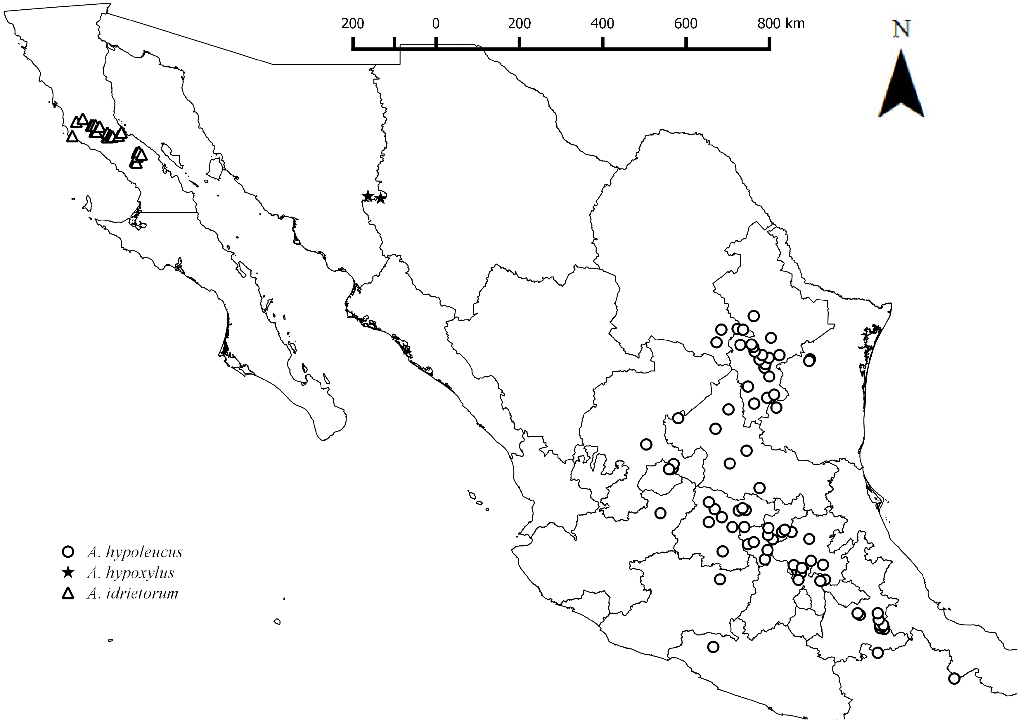
Distribution:— One of the species with the largest distribution in Mexico, in mountainous areas throughout most of the Mexican Highplains; from Coahuila, Nuevo León and Tamaulipas, through San Luis Potosí and Zacatecas to Querétaro, State of Mexico, south of Puebla and isolated in the center of Oaxaca ( Fig. 13 View FIGURE 13 ).
Habitat:— Stony hills; calcareous and gypsic soils; grassy slopes; clearing scrub forest; piedmont scrub; oak forest; xeric scrublands; grasslands with prairie dogs; wet gullies; Douglas fir - fir - pine forest; pine - manzanita - sumac association; peach crop; 1400–3500 m
Comments:— Astragalus hypoleucus is the only species with dolabriform pubescence distributed south of the Tropic of Cancer, from northeastern San Luis Potosí to Oaxaca. The other four species with dolabriform trichomes are A. amphioxys (Chihuahua) , A. arizonicus (Sonora) , A. humistratus (Sonora and Chihuahua) and A. lotiflorus (Coahuila) . Sometimes abundant in overgrazed areas along road.
Specimens examined:— AGUASCALIENTES: 4–8 September 1967, Ca. 20 km. east of Rinón de Romos , road to Asientos, between Cerro Altamira and Cerro de San Juan, R. McVaugh 23701 ( NY) ; 31 October 1967, Cerro de San Juan ± 5 km al E de Tepezalá , Medellín-Villa-Takaki s.n. ( IBUG, MEXU) ; 1 November 1967, Ladera sur del Cerro Palaira , 4 km al W de Asientos, Rzedowski 25088 ( ENCB) . COAHUILA: 27 May 1980, Ejido El Puerto, aprox. 6 km Los Lirios, Mpio. Arteaga , J. A. Villarreal 704, R. López A. ( ANSM) . 29 July 1995, Camino Los Lirios-El Cercado , Mpio. Arteaga, Hinton et al. 25407 ( ANSM) ; 24 June 1994, Sierra de Arteaga, Rcho. El Tirol, Cañón de Jamé , 12km NE Jamé, J. A. Villarreal 7707, J. Valdés R, M. A. Carranza ( ANSM, MEXU) ; 3 October 1986, Cañón Jame aprox. 20 km. al Noreste de la carretera Nacional (57), J. A. Villarreal 3403, M. A. Carranza ( ANSM, ENCB, MEXU) ; 22 June 1992, Sierra Zapalinamé , Hinton 22076 et al ( NY) ; 23 October 1963, Carneros Pass, 23 mi. south of Saltillo , H. D. Ripley 13267, R. C. Barneby ( MEXU, NY) ; 19 May 1974, Lomas de Lourdes, Saltillo , J. Marroquín 2777 ( ANSM) ; VIII-1944, Aserradero , Sierra Zapalinamé, Hno. E. Lyonnet [440800015] ( MEXU) ;? August 1944, Aserradero , Sierra Zapalinamé, E. Lyonnet [440800015] ( MEXU) . ESTADO DE MEXICO: 26 June 1977, Cerro Ahumada , 6 km al N de Huehuetoca, Rzedowski 35003 ( ENCB) ; 10 October 1976, Terrenos de Jaltepec , A. Ventura A. 2274 ( ENCB) ; 10 August 1977, Entronque Cuautlacingo-Otumba, F. J. Espinosa 231 ( ENCB) ; 15 June 1976, Otumba , Ahuatepec, A. Ventura A. 1598 ( ENCB) ; 23 July 1974, Cerro del La Cruz , 5 km al NW de Tepotzotlán, Rzedowski 31939 ( ENCB) ; 8 June 1981, Cerro La Manga , Mpio. Apaxco, Romero-Rojas 1337 ( ENCB) ; 3 August 1976, partes basales del Cerro Sincoque, del lado SW, Mpio. Huehuetoca, Rzedowski 34357 ( ENCB) . GUANAJUATO: 13 October 1986, Rzedowski 41648 ( CIIDIR, ENCB, IBUG, IEB) ; 18 October 1986, 27 km al S de Dolores Hidalgo, sobre la carretera a San Miguel Allende, Rzedowski 41047 ( CIIDIR, ENCB, IEB) ; 28 June 1996, Cerros calizos cercanos a Calera , 11 km al N de Irapuato, Rzedowski 53161 ( ANSM, CIIDIR, ENCB, IEB, MEXU, USON) ; 27 June 1987, 2 km al NE de Empalme Escobedo, Rzedowski 43448 ( CIIDIR, ENCB, IBUG, IEB, MEXU) ; 21 June 1971, San Miguel de Allende , P. Genelle 811 ( NY) ; 28 October 1963, Open Stony Summits. Sierra back of Guanajuato, H. D. Ripley 13343, R. C. Barneby ( MEXU, US) ; 28 July 1986, 5 km al ENE de Empalme Esobedo, Mpio. De Comonfort, Rzedowski 40113 ( ENCB, IBUG, IEB) ; 20 July 1991, San Felipe, Rzedowski 50671 ( IEB, MEXU) ; 1 August 2005, El Charco del Ingenio, Mpio. San Miguel Allende, F. Rodríguez 3053 ( IEB) ; 5 August 1991, La Misión de Abajo , carretera hacia Victoria, E. Ventura V. 9406, E. T. López ( ENCB, IEB, MEXU) ; 6 April 1990, Mesas del pueblo, E. Ventura V. 7863, E. T. López ( ENCB, IEB, MEXU) ; 21 August 1990, Victoria, Los Nogales, E. Ventura V. 8599, E. T. López P. ( ENCB, IEB, MEXU) ; 5 June 1990, La Concepción, E. Ventura V. 8055, E. T. López P. ( ENCB, IEB, MEXU,) ; 31 July 1991, E. Ventura V. 9360, La Merced, carretera Pozos-San José, Mpio . San Luis de la Paz, E. T. López P. ( IEB) ; 12 June 1990, Ojo de Agua, Mpio. De Pozos , E. Ventura V. 8074, E. López P. ( ENCB, IEB) ; 4 September 1989, 10 km al Sur de Pozos , E. Ventura E. 7193, E. López P. ( IEB, MEXU) 12 August 1990, 4 km al S de la cumbre del Cerro El Cubilete, Rzedowski 49801 ( IEB, MEXU) ; 11 August 2005, 4.5 km de Aguas Buenas , Mpio. Silao, E. Pérez C. 4565 ( IEB) ; 14 September 2002, Cerro La Cañada , 1 km al N del Charape de los Pelones, J. Gutiérrez G. 536 ( IEB, MEXU) ; 8 September 1988, Cerca de Palmillas , al NE del Municipio Comonfort, A. Mora B. 910 ( IEB) ; 24 September 1994, 4 km al S de Pozoz, Mpio. San Luis de la Paz, sobre la carretera a San José, Rzedowski 52642 ( IEB) ; 24 September 1994, 5 km al W de Los Pozoz, Mpio. San Luis de la Paz, sobre el camino a al autopista, Rzedowski 52594 ( IEB) ; 10 July 1988, Alrededores de El Guajolote , Mpio . San José de Iturbide, Rzedowski 46913 ( IEB) ; 12 August 1990, 2 k al S de San José de Tránsito, Mpio. Silao, cerca del aeropuerto, Rzedowski 48927 ( IEB) ; 23 September 1994, al W de La Españita, Mpio. San José de Iturbide, Rzedowski 52565 ( IEB) . HIDALGO: 9 November 1976, Mineral de la Reforma, M. Medina C. 1769 ( CIIDIR, ENCB, MEXU) ; 13 August 1913, Tula, C. R. Orcutt 6255 ( MEXU, NY) ; IX-1903, El Salto, J. N. Rose 7089, J. H. Painter ( NY) ; 2 August 1902, El Salto, C. G. Pringle 9721 ( NY, US) ; 20 July 1896, Near Tula, C. G. Pringle 6366 ( ENCB, NY) ; 6 October 1980, Camino a Minas de San Miguel , 10 kms al norte de Zimapán, R. Hernández 5111, D. Rodríguez ( MEXU, NY) ; 12 August 1981, Mesa Doñana, R. Hernández 6356 et al. ( MEXU, NY) ; 12 August 1990, Barranca “El Salto”, al SW del poblado Tecajique , vertiente oriental de la sierra de Chicavasco, ejido Tecajique, I. Díaz V. 938 ( IBUG, MEXU) ; 7 June 1976, Zempoala, A. Ventura A. 1497 ( CAS) ; 8 November 1975, Terrenos de Tepeapulco , A. Ventura A. 527 ( ENCB) ; 28 September 1976, Cerro de Santa María Tecajete , A. Ventura A. 2190 ( ENCB) ; 16 December 1975, El Xihuingo, A. Ventura A. 715 ( ENCB) ; 31 August 1980, 2 km al N de Huixmi, Mpio. Tlaxiaca, Rzedowski 36969 ( ENCB) ; 29August 1965, Cerro Ventoso, entre Pachuca y Real del Monte, Rzedowski 20574 ( ENCB) ; 9 September 1976, Xolostitla , 8 km al ESE de Pachuca, Mpio. Pachuqilla, M. Medina C. 1751 ( ENCB) ; 24 March 1981, Unos 10 Kms. al este de Metzquititlan , ( El Banco), R. Hernández M. 5572, D. Rodríguez B. ( ENCB, MEXU) . JALISCO: 1 September 1958, 2 miles southwest of San Juan de Los Lagos, R. McVaugh 17617 ( CAS, MEXU, NY) . MICHOACÁN. 3 September 1991, Cerro del Mezquital, J. M. Escobedo G. 2104 ( ENCB, IEB, MEXU 31 July 1992, Cerro Las Cinsinillas, J. M. Escobedo 2376 ( ENCB, IEB, MEXU) . NUEVO LEÓN: 16 May 1981, Cerro del Potosí, camino a la cima del cerro, J. A. Villarreal 1217, L. Arce, M. A. Carranza ( ANSM, MEXU) ; 23 July 1993, Ascención-La escondida, Hinton et al. 23101 ( ANSM) ; 21 June 2003, 5 km por Carr. Dr. Arroyo-Matehuala, E. Estrada 15784, C. Yen ( MEXU) ; 24 August 1989, Sierra El Soldado, camino San Antonio Peña Nevad-Puerto Pinos, Mpio. Mier y Noriega, J. A. Villarreal 4917, M. A. Carranza, G. Nesom, J. Norris ( ANSM, TEX) ; 26 August 1989, 12 km al NNE de La Encantada, camino a Zaragoza , Mpio. Zaragoza, J. A. Villarreal 5136, M. A. Carranza, G. Nesom, J. Norris ( ANSM) ; 17 June 1992, Áreas cercanas a Santa Rita , Mpio. Galeana, J. A. Villarreal 6876, M. A. Carranza ( ANSM) ; 16 May 1981, Cerro del Potosí, camino a la cima del cerro, J. A. Villarreal 1217, L. Arce. M. A. Carranza ( ANSM) ; 4 June 1987, Ejido Sant Rosa , Mpio. Iturbide, E. Estrada 912 ( ANSM, IBUG, MEXU) ; 28 May 1987, Rancho Casas Blancas, Faldas del Cerro El Potosí, Mpio. Galeana, E. Estrada 997 ( ANSM, MEXU) ; 26 June 1978, Puerto el Pino, Hinton et al. 17398 ( ANSM, CIIDIR, ENCB, MEXU) ; 26 November 1966, Sierra Madre Oriental w. of Iturbide , ascent to Pto. de los Encinos, H. D. Ripley 14780, R. C. Barneby ( NY) ; 3 April 1902, Montemorelos, E. W. Nelson 6091 ( NY) ; 22–23 July 1977, Ca. 1 mi WSW of San Pablo in small valley, 15 mi E of San Rafael off Highway 57, C. Wells 68, G. Nesom ( NY, TEX-LL) ; 27–30 July 1977, Area of Cerro Peña Nevada, ca. 12 km. NE of San Antonio Peña Nevada, 30 km E of Doctor Arroyo , N and NE slopes of mt know locally as Picacho Onofre, and ridges and valleys ca. 5 km. to the NE of this peak, C. Wells 356, G. Nesom ( NY) ; 23 July 1993, Ascención- La escondida, Hinton 23101 et al ( NY) ; 6 August 1971, Along Nuevo Leon Highway 60, 11 miles east of San Roberto Junction and 4.7 miles west of San marcos, J. L. Reveal 2630, W. J. Hess, R. W. Kiger ( MEXU, NY) ; 4 August 1936, Hacienda Pablillo , Galeana, M Taylor 51 ( CAS) ; 25 October 1982, In a gully northwest of Ejido Santa Rosa, 4.1 miles south of Iturbide, Loma la Banderra , J. W. Grimes 2331, K. Nixon, L. Dorr, S. Sundberg ( NY) ; 28 May 1987, Rancho Casas Blancas, faldas del Cerro El Potosí, E. Estrada 987 ( NY) ; 15 June 1989, Ejido Santa Rosa, E. Estrada 1507 ( NY, TEX) ; 23 September 1973, Along Nuevo Leon Highway 68, 12.2 miles south of the junction of highway 60 and 1.5 mile south of Pablillo, about 139 miles north of Matehuala , Sierra Madre Oriental, J. L. Reveal 3405, N. D. Atwood ( NY) ; 22 July 1977 / 23 July 1977, Ca. 1 mi WSW of San Pablo in small valley, 15 mi E of San Rafael off Highway 57, C. Wells 101, G. Nesom ( NY, TEX-LL) ; 29 October 1964, 2.5 miles S. of Galeana, H. D. Ripley 13588, R. C. Barneby ( NY) ; 4 July 1985, 42.1 mi (67.3 km) SE of Hwy 57 at San Rafael on gravel road to 18 de marzo, 15.6 (25 km) E of S. Fco. Javier, C. P. Cowan 5430, M. Luckow, N. Jacobson ( NY) ; 11 May 1989, Camino Los Mimbres-El Orito, E. Estrada 1460, S. Favela ( MEXU) ; 20 October 1984, 12.2 mi along dirt road turn-off to Ejido Capadero. just north of Dr. Arroyo. 34.5 mi from Banco del Centro, Matehuala. Sierra, J. Saunders-Sherrer 1352ª, K. C. Nixon ( MEXU) ; 23 September 1959, Puerto de Cieneguillas , Mpio. Galeana, D. Fuentes Ch. s.n. ( ENCB) ; 5 July 1980, El Barreno, Mpio. Aramberri, Hinton 17864 ( ENCB) . OAXACA: non date, Jalahui. Estudios sucesionales de la vegetación, R. Noriega 48 ( MEXU) . PUEBLA: 19 November 1966, 12 miles n. of Tehuacan near Azumbilla , H. D. Ripley 14733, R.C. Barneby ( NY, US) ; 5 August 1936, Hacienda Pablillo , Galeana, M. Taylor 51 ( NY) ; 12 August 1982, 10 km al S de Siberia , R. Torres 1116, J. López, O. Oropeza y R. Sánchez ( NY) ; 15 April 1985, On the road to Nicolas Bravo 12.7 kms south of the Puebla-Orizaba road, ca. 1 km north of Nicolas Bravo , J. Grimes 2788, P. Tenorio ( MEXU, NY) ; VII-1907, Vicinity of Puebla, Acatjinco ( Dirt Esperanza ), Bro. Amable 2020, Bro Arsene ( NY) ; 23 July 1978, Ca. 2 km N of Saltillo La Fragua, Hwy 140 from Jalapa to Puebla, J. M. Poole 1557, G. Guzmán ( IEB, MEXU) ; 16 July 1991, Hwy 28, N of Azumbilla (which is Tehuacan); upper end of Barranca Rincon Coyote at the pass between Azumbilla and Canada Morelos; ca. 4 air km S-SE of Canada Morelos, Mayfield, A.L. Hemple, A. Jack 901 ( MEXU) ; 30 July 1960, 1 km W of Tepiaca , F. W. Gould 9229 ( ENCB) . QUERÉTARO: 8 August 1976, El Batán, E. Argüelles 473 ( MEXU, NY) ; 23 August 1961, 8 miles east of Queretaro, U. T. Waterfall 16515 ( NY) ; 18 August 1905, Near San Juan Del Rio, On a stony hillside, J. N. Rose 9584, J. H. Painter, J. S. Rose ( US) ; 3 July 1987, Camino a Los Cues, km. 4 aprox. cerca desv. a Cotita, E. Argüelles 2974 ( IEB, MEXU) ; 25 September 1978, 1 km al S de Vizarrón , S. Zamudio R. 3378 ( IEB, MEXU) ; 19 July 1994, R. Hernández M. 10698, J. Orozco H., C. Orozco L. ( IEB, MEXU) ; 16 August 1996, 4.5 km al S de Vizarrón, Mpio. Cadereyta , S. Zamudio 9874, E. Pérez C. ( IEB) ; 23 August 1988, Ladera N del Peña de Bernal, Mpio. Ezquiel de Montes , H. Díaz B. 4839 ( IEB) ; 23 June 1991, Río Atarjea , 4–6 km al SW de El Limón, Mpio. Arroyo Seco, E. Carranza 3220 ( IEB) ; 1 September 1984, La Venta, E. Argüelles 2178 ( IEB, MEXU) ; 16 September 1977, Cerro Azul, S. Zamudio 2445 ( IEB, MEXU) ; 16 August 1989, 5 km al NE de bernal, Mpio. De Cadereyta , sobre la Carretera a Tolimán, Rzedowski 48745 ( ENCB, IEB) ; 18 November 2012, Maguey Verde, southeast of Pinal de Amoles , D.S. Gernandt 1248, C. Reséndiz A., P. Rosas E., A. Otríz M. ( MEXU) ; 15 November 2000, Carretera Colón-Tolimán, R. Hernández M. 11909 ( MEXU) ; 2 July 1983, Camino a Los Cues No. 2, E. Argüelles 2313 ( IEB) . SAN LUIS POTOSÍ: 13 August 1985, F. Gómez L. 714 ( ANSM, ENCB) ; 5 October 1961, La Joya Chica Soledad, A. Gómez 411 ( ANSM, ENCB, MEXU) ; n.d., Sierra de Catorce , F. Rodríguez 14 ( NY) ; 31 October 1967, Cerro de San Juan ± 5 km al E de Tepezalá , Medellín-Villa-Takaki s.n. ( ANSM) ; 12 November 1964, n.e. of Ventura, H. D. Ripley 13773, R. C. Barneby ( NY) ; 20August 1959, 18 miles northeast of San Luis Potosí, U. T. Waterfall 15689 ( NY) ; 12 October 1961, Alrrededores de la Joya Chica , Soledad, A. Gómez G 494 ( NY) ; 5 September 1961, La Joya Chica Soledad, A. Gómez G. 411 ( ENCB, NY) ; 13 January 1995, Aprox. 1 km al S de la Alberca, Mpio. Catorce, E. Pérez C. 3109 et al ( IEB) ; 30 August 1955, 10 km al NE de Laguna Seca, Mpio. De Soledad , Rzedowski 6349 ( ENCB) ; 8 October 1979, Mpio. Real deCatorce, Sierra de Catorce, Cerro La Cuchilla , 13 km al E de Wadley, 1 km al E de Tierras Negras , J. García P. 1303 et al. ( ENCB) ; 27 September 1955, 3 km al S de Cerro San Pedro, Rzedowski 6162 ( ENCB) ; 18 September 1954, Sierra de San Miguelito , al SW de la Cd . San Luis Potosi, Rzedowski 4667 ( ENCB) ; 21 April 1956, La Joya 4 km al NW de Ventura, Mpio. Villa Hidalgo, Rzedowski 7546 ( ENCB) . TAMAULIPAS: 11 July 1949, 3 mi. n. of Miquihuana, Stanford, Lauber, Taylor 2383 ( US) , 2395 (NY); 24 May 1976, 3 km al N de La Joya de Herrera , F. González-Medrano 9120 ( MEXU) ; 12 July 1983, 20 km. al Norte de la Pérdida, F. González-Medrano 13197 ( MEXU) ; 12 March 1985, 5 km al NE del Ejido El Gavilán, Sierra de San Carlos , P. Hiriart 646, V. Juárez, R. Molezadzki, J. Jiménez ( MEXU) . VERACRUZ: 12 December 1963, Acultzingo, H. S. MacKee 11048 ( NY) ; 6 July 1990, Los Baños, apox 25 km al WSW de Huayacocotla, Cerro de San Nicolás de Atexcoco , Hidalgo, Rzedowski 49554 ( IEB) . ZACATECAS: 16 August 1959, 7 miles northwest of Zacateca , U. T. Waterfall 15607 ( NY) ; 20 August 1974, Just W of Zacatecas, R. W. Spellenberg 3802 ( NY) ; 24 July 1986, Ejido Tierra Blanca , Manrique, Lozano, Bravo 1305 ( MEXU) . f Miquihuana, Stanford , Lauber, Taylor 2383 ( US) , 2395 (NY); 24 May 1976, 3 km al N de La Joya de Herrera , F. González-Medrano 9120 ( MEXU) ; 12 July 1983, 20 km. al Norte de la Pérdida, F. González-Medrano 13197 ( MEXU) ; 12 March 1985, 5 km al NE del Ejido El Gavilán, Sierra de San Carlos , P. Hiriart 646, V. Juárez, R. Molezadzki, J. Jiménez ( MEXU) .
| IBUG |
IBUG |
| MEXU |
MEXU |
| ANSM |
ANSM |
| IEB |
IEB |
| USON |
USON |
| CAS |
USA, California, San Francisco, California Academy of Sciences |
| TEX |
TEX |
| NY |
William and Lynda Steere Herbarium of the New York Botanical Garden |
| IBUG |
Universidad de Guadalajara |
| MEXU |
Universidad Nacional Autónoma de México |
| ENCB |
Universidad de Autonoma de Baja California |
| ANSM |
Universidad Autónoma Agraria Antonio Narro |
| CIIDIR |
Instituto Politécnico Nacional |
| IEB |
Instituto de Ecología, A.C. |
| USON |
Universidad de Sonora |
| US |
University of Stellenbosch |
| CAS |
California Academy of Sciences |
| TEX |
University of Texas at Austin |
No known copyright restrictions apply. See Agosti, D., Egloff, W., 2009. Taxonomic information exchange and copyright: the Plazi approach. BMC Research Notes 2009, 2:53 for further explanation.
|
Kingdom |
|
|
Phylum |
|
|
Class |
|
|
Order |
|
|
Family |
|
|
Genus |
Astragalus hypoleucus S. Schauer, Linnaea
| Castillón, Eduardo Estrada, Quintanilla, José Ángel Villarreal, Delgado-Salinas, Alfonso & Rebman, Jon P. 2023 |
Hamosa hypoleuca (S. Schauer)
| Rydb. 1927: 334 |