
Ancistrus triradiatus Eigenmann 1918
|
publication ID |
https://doi.org/ 10.11646/zootaxa.4552.1.1 |
|
publication LSID |
lsid:zoobank.org:pub:13CE299C-2085-4BBD-989D-75B417CE1CAC |
|
DOI |
https://doi.org/10.5281/zenodo.5932348 |
|
persistent identifier |
https://treatment.plazi.org/id/03F787A5-BA10-C802-FF26-2036FBCBFD4B |
|
treatment provided by |
Plazi |
|
scientific name |
Ancistrus triradiatus Eigenmann 1918 |
| status |
|
Ancistrus triradiatus Eigenmann 1918 View in CoL
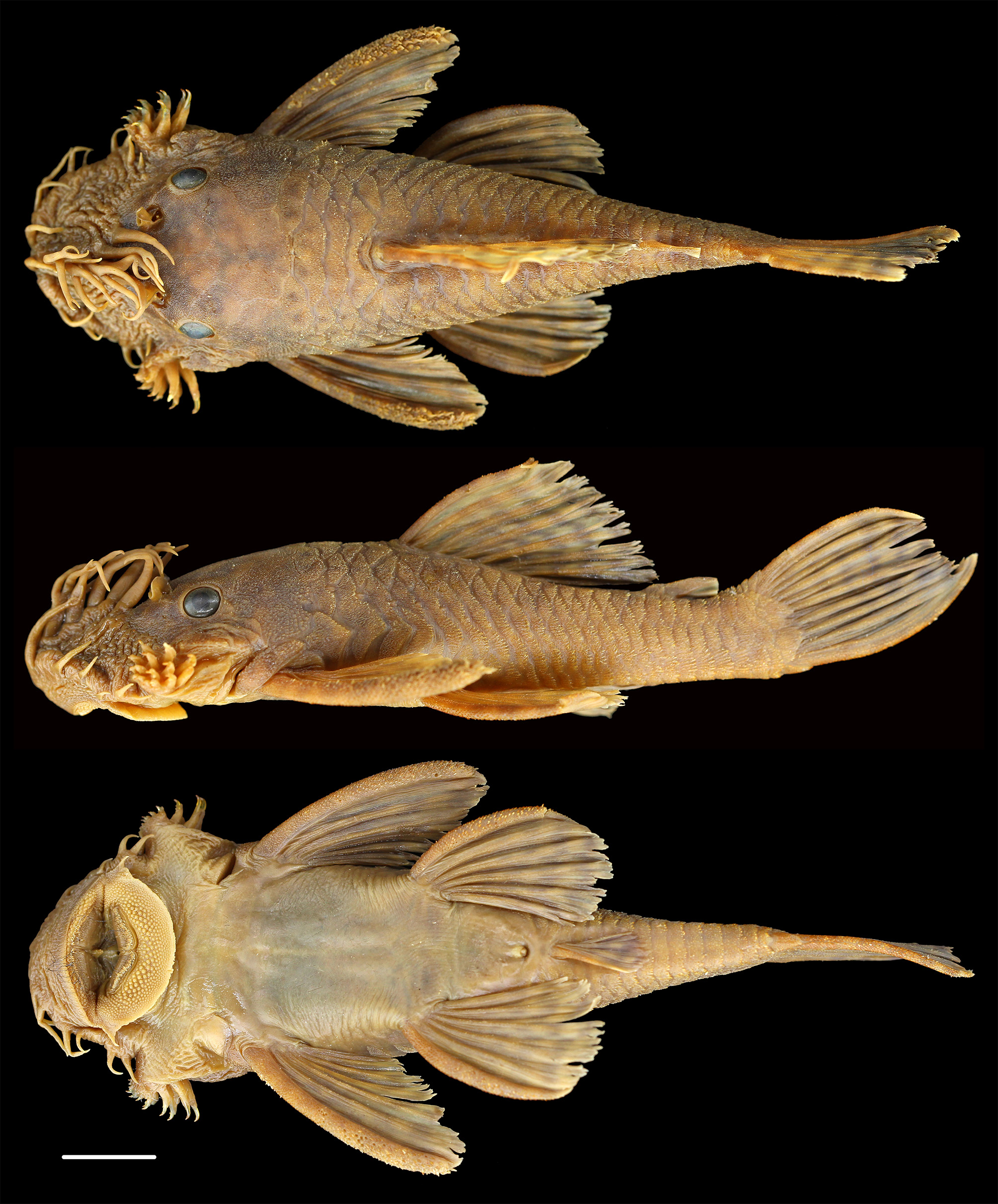
( Figs. 25–27 View FIGURE 25 View FIGURE 26 View FIGURE 27 )
Ancistrus triradiatus Eigenmann, 1918: 680 View in CoL . Type locality: Quebrada Cramalote [probably a misspelling of Gramalote], Villavicencio; Andes east of Bogotá [upper Meta River drainage, Colombia]. Holotype: CAS 60164 (illustrated in Eigenmann 1922: 224, pl.13, figs. 3–4).
Specimens examined. Colombia. Orinoco River Basin: ANSP 80468 About ANSP (1, 47.5 mm SL), Río Meta drainage, Villavicencio . 4.15788, -73.62552, 1931; ANSP 131665 About ANSP (1, 59.2 mm SL), Hacienda Humacita, Caño Angosturas at and just below hacienda at Humacitas, 22-Feb-1972; ANSP 133129 About ANSP (1, 53.3 mm SL), Meta River drainage, Tributary of Caño La Raya , 1 km N of La Siberia, 4.08333, -73.08333; 24-Mar-1975 ; ANSP 163445 About ANSP (2, 68.9–88.5 mm SL), Caño el Guio, 3.95, -73.15, 17–Mar-1973 ; ANSP 163449 About ANSP (2, 47.0– 69.4 mm SL), Caño El Viento, Finca El Viento S of Matazul , 4.13333, -72.65, 18-Mar-1973 ; ANSP 163452 About ANSP (1, 86.3 mm SL), Hacienda Humacita, small stream flowing generally south, presumably the Lake Mozambique complex, 3.95799, -73.05453, 21-Feb-1972 ; CAS 60165 (4, 42.8–66.7 mm SL), Quebrada Cramalote [a misspelling of Gramalote], at Villavicencio, 4.14592, - 73.64503; CZUT–IC 6302 (1, 66.4 mm SL), Orotoy River , Station 4: Approximately 100 m upstream of the old dump site on the bridge on the Orotoy River on hwy of Castilla La Nueva that leads to Pozos de Acacias , 3.86936, -73.637, 2-Dec-2010 ; CZUT–IC 6398 (3, 55.5–80.1 mm SL), Orotoy River, Station 3: Waters below the Chichimene bridge, after the confluence with San Francisco creek , 29-Nov-2010 ; CZUT–IC 6584 (1, 83.3 mm SL), Orotoy River, Station 3: Waters below the Chichimene bridge, after the confluence with San Francisco creek , 25-Mar-2010 ; CZUT–IC 6658 (1, 75.1 mm SL), Orotoy River, Station 1: Waters upstream of the confluence with Pajuil creek, at the entrance in front of the aqueduct in the township of San Juanito, 3.93576, -73.81287, 10-Sep- 2010 ; CZUT–IC 7024 (3, 51.7–66.5 mm SL), Orotoy River, Station 7: Orotoy River , approximately 50 m downstream of Rancho Alaska, township Barroblanco ( Castilla la Nueva ), 3.84294, -73.49494, 8-Sep-2010 ; CZUT–IC 7060 (1, 48.2 mm SL), Orotoy River, Station 5: Aprox. 200 m downstream of old dump site of Ecopetrol, 3.8683, -73.62921, 9-Sep-2010 ; FMNH 58558 About FMNH (3, paratypes, 38.5–61.8 mm SL), Gramalote creek, Villavicencio , 4.15733, -73.62792, 27-Mar-2005 ; FMNH 94777 About FMNH (1, 49.6 mm SL), 22 km E of Villavicencio in a gallery forest on finca La Libertad, 4.14857, -73.45851, Jun–78 ; IAvHP 2220 (1, 103.4 mm SL), no precise locality data probably at bridge near town of San Juan de Arama , 3.37014, -74.02949, 27-Mar-73 ; IAvHP 5129 (1, 73.2 mm SL), Dpto. Meta, near town of Granada, 3.66667, -74.16667, 5-Feb-2005 ; IAvHP 5140 (1, 95.6 mm SL), Dpto. Meta, near town of Granada, 3.66667, -74.16667, 5-Feb-2005 ; IAvHP 5141 (3, 73.3–97.1 mm SL), Dpto. Meta, near town of Granada, Caño Sardinata, sitio Bocas vía La Carpa, inspección Puerto Caldas, 3.47522, -73.72, 5-Feb-2005 ; IAvHP 6999 (1, 69.8 mm SL), Dpto. Vichada, Mcpo. Cumaripo, playa rocoso, Río Tomo , 5.37806, - 67.85222, 30-Jan-2004 ; IAvHP 8532 (1, 93.1 mm SL), Dpto. Meta, Acacías, Caño San Luis inspección San Isidro, 3.76667, -73.3, 1–Aug–06 ; IAvHP 8533 (3, 71.7–79.4 mm SL), Dpto. Meta, Acacías, Caño Hondo, upstream from Guamaral , 3.91667, -73.83333, 1–Aug–06 ; ICN 1173 View Materials (4, 61.6–94.6 mm SL), Dpto. Meta, Río Acacias in Acacias , 3.97352, -73.76651, 26-Feb-1987 ; ICN 1190 View Materials (2, 81.7–91.4 mm SL), Dpto. Meta, Villavicencio, Caño Rosablanca, Sistema Río Metica , 4.0197, -73.638, 27-Jan-1971 ; ICN 1192 View Materials (4, 68.6–107.2 mm SL), Dpto. Meta, Quebrada Gramalote near Villavicencio , 4.14592, -73.64503, 1-Jan-1968 ; ICN 1469 View Materials (1, 76.7 mm SL), Dpto. Cundinamarca, Río Guayuriba / Meta, 10 km al S de Rincón de Pompeya, 4.01879, -73.4339, 17-Dec-1987 ; ICN 3461 View Materials (1, 89.7 mm SL), Dpto. Meta, Quebrada Gramalote, near Villavicencio , 4.14592, -73.64503, 1-Jan-1968 ; IUQ 2908 View Materials (2, 51.3– 63.4 mm SL), Dpto. Meta, Cano Piedra en la via Vista Hermosa–Pto. Lucas, 3.09417, -73.7825; UF 26019 (2, 54.7–60.6 mm SL), Tributary of Yucao River ca 4.7 km W of Puerto Gaitan, 4.31468, -72.12849, 5-Jan-1973 ; UF 33478 (1, 67.0 mm SL), Tributary of Yucao River ca 4.7 km W of Puerto Gaitan, 4.31468, -72.12849, 5-Jan-1973 ; UF 33479 (0), Tributary of Yucao River ca 4.7 km W of Puerto Gaitan, 4.31468, -72.12849, 5-Jan-1973 ; UF 33480 (4, 64.9–88.3 mm SL), Tributary of Yucao River ca 4.7 km W of Puerto Gaitan, 4.31468, -72.12849, 5-Jan-1973 ; UF 33569 (2, 52.7–64.0 mm SL), Tributary of Yucao River ca 4.7 km W of Puerto Gaitan, 4.31468, -72.12849, 8- Jan-1973 ; UF 33653 (1, 51.4 mm SL), Roadside creek E of Macarena Mountain 9.6 km NE of Vistahermosa, 3.20135, -73.66437, 10-Jan-1973 ; USNM 120095 About USNM (1, 104.1 mm SL), Dpto. Meta, Acacias, 3.97378, -73.76707 ; Colombia, Amazon River Basin: IAvHP 9139 (2, 64.8–65.7 mm SL), Dpto. Amazonas, Quebrada afluente del Calderón, 45 minutos N of Estación Zafire, -3.97778, -69.89222, 13-Dec-2005 ; IUQ 968 View Materials (1, 61.8 mm SL), Zanjón Picudo Km 7 en la via Villa Garzón - San José de Fragua , 1.08793, -76.62714, 10-Dec-1997 ; IUQ 1059 View Materials (1, 57.5 mm SL), Caquetá, Río Fragua , 1.33404, -75.97766, 13-Dec-1997 ; IUQ 1765 View Materials (1, 50.9 mm SL), Caquetá, Quebrada tributary of Río Yurayaco , pueblo Yurayaco, near Villa Garzón, 1.03333, -76.66667, 16-Dec-1997 ;
Venezuela. Orinoco River Basin: ANSP 160148 About ANSP (1, 78.8 mm SL), Estado Bolivar, Caño Caiman at crossing of Caicara–Puerto Ayacucho Highway, 19.2 km W of Ciudad Bolivar–Caicara Hwy., 7.35472, -66.26458, 29-Nov- 1985 ; ANSP 160770 About ANSP (1, 74.3 mm SL), Estado Bolivar, Morichal, 27 km from Pto. Ayacucho on hwy. to Caicara , 5.84368, -67.45471, 15-Nov-1985 ; ANSP 165826 About ANSP 2 41.4–42.2 mm SL), Estado Apure, Cinaruco / Caño Potrerito, ca. 24 km S Río Cinaruco, on road to San Fernando de Apure, 6.41667, -67.53333, 11-Nov-1989 ; ANSP 166766 About ANSP (1, 59.3 mm SL), Estado Anzoátegui, near Soledad, Laguna Tineo, 8.19111, -11.46894, 30-May-1988 ; ANSP 171089 About ANSP (1, 51.7 mm SL), Estado Bolivar, Río Aro , Salto El Pájaro, 7.7434, -64.17152, 2-Nov-1988 ; ANSP 185268 About ANSP (1, 47.9 mm SL), Estado Bolivar, Río Orocopiche, ca. 15 km from mouth in Río Orinoco, downstream from Route 19 bridge, 8.05, -63.66667, 3-Nov-1979 ; AUM 5691 View Materials (2, 62.7–84.1 mm SL), Estado Portuguesa, Caño Maraca, Guanare–Guanarito road at road km 60, 8.8275, -69.345, 17-Dec-1999 ; AUM 22190 (1, 80.1 mm SL), Estado Táchira, Río Quinimari in Santa Ana, 6 road km from Hwy. 5, 7.665, -72.25111, 21-Dec-1999 ; AUM 22243 (1, 39.9 mm SL), Estado Bolivar, Caño San Felipe, 22 km SW Caicara on road to Puerto Ayacucho , 7.46991, - 66.18156, 24-Dec-1999 ; AUM 22297 (1, 70.6 mm SL), Estado Bolivar, Río Chaviripa, on Caicara–Puerto Ayacucho road, 7.1325, -66.49889, 24-Dec-1999 ; AUM 22312 (1, 93.5 mm SL), Estado Bolivar, Río Chaviripa , at base of falls, ca. 2 km SE Caicara–Puerto Ayacucho road, 7.11389, -66.47306, 25-Dec-1999 ; AUM 22554 Estado Apure, Caño Guárico, ca. 38 km S Bruzual on road to Elorza , 7.71306, -69.33056, 29-Dec-1999 ; AUM 22631 (6, 54.5–87.8 mm SL), Estado Apure, Caño Potrerito, ca. 15 km N Puerto Páez on road to San Fernando de Apure, 6.41194, -67.53194, 26-Dec-1999 ; AUM 22750 (1, 37.4 mm SL), Estado Apure, Caño La Pastora , on road to UNELLEZ módulo, 7.44444, -69.43472, 28-Dec-1999 ; AUM 22829 (3, not measured), Estado Portuguesa, Caño Maraca, Guanare–Guanarito road at road km 60, 8.8275, -69.345, 1-Jan-2000 ; AUM 36437 (1, 75.3 mm SL), Estado Bolívar, Río Paragua / Caroní drainage, Río Chiguao , 19.4 km E. of La Paragua, 6.7892, -63.15871, 8-Jun- 2003 ; AUM 36554 (3, 50.8–86.2 mm SL), Estado Bolívar, Río Claro , 50.5 km SE of Ciudad Bolívar, 7.92358, - 63.11528, 10-Jun-2003 ; AUM 39894 (9, 68.9–80.2 mm SL), Orinoco Delta, Caño Mánamo near Coporito , 8.91667, -62.0, 5-Apr-1980 ; AUM 42972 (1, 53.6 mm SL), Río Orinoco at Puerto Venado, 4.3 km S of Samariapo, 56.4 km SSW of Puerto Ayacucho, 5.2106, -67.80495, 26-Feb-2005 ; AUM 54016 (1, 0), Estado Portuguesa, Quebrada Ajaque, 18.6 km W of Guanare, at via Las Panelas , 9.08294, -69.91548, 15-Mar-2010 ; AUM 54047 (5, not measured), Caño Las Panelas, Balneario Las Panelas via a las Cruces , 20.4 km W of Guanare, 9.09286, - 69.93016, 15-Mar-2010 ; FMNH 45709 About FMNH (1, 80.4 mm SL), Estado Bolivar, Chimantá–tepui, Río Abacapa Camp 1, altitude 1300 m, 5.27629, -62.19496, 4-Apr-1953 ; INHS 27675 About INHS (1, 88.4 mm SL), Estado Apure, Caño Potrerito, hwy. bridge between San Fernando and Puerto Páez , 6.41333, -67.53222, 22-Jan-1992 ; INHS 27764 About INHS (1, 104.7 mm SL), Estado Barinas, Caño Curito at Hwy. 5, 7.9735, -71.00833, 7-Jan-1992 ; INHS 30006 About INHS (1, 63.9 mm SL), Estado Barinas, Caño Hondo, Agua Negra, 8.5752, -69.80073, 14-Jan-1993 ; INHS 31411 About INHS (1, 64.1 mm SL), Estado Anzoátegui, Río Tigre , near El Tigre, (Caño Mánamo Dr.), 8.896603, -64.147740, 6-Jan-1994 ; INHS 34732 About INHS (1, 72.5 mm SL), Estado Barinas, Río Curito ( Río Suripá drainage, 8 km NE San Antonio on Hwy. 5, 7.91028, - 71.08222, 3-Feb-1995 ; INHS 36333 About INHS (1, 62.7 mm SL), Estado Guárico, Río Aguaro , 8.05167, -66.42611, 10-Jan- 1995 ; INHS 36334 About INHS (1, 77.6 mm SL), Estado Guárico, Río Aguaro , 15 km S of Paso Cachimbo, 7.96668, - 66.42963, 10-Jan-1995 ; INHS 55532 About INHS (1, 57.5 mm SL), Estado Bolívar, Río Chaviripa, on Caicara - Pto. Ayacucho Rd. , 7.1325, -66.49889, 24-Dec-1999 ; INHS 61322 About INHS (1, 61.2 mm SL), Estado Barinas, Río Bum Bum in Bum Bum , 8.27294, -70.77155, 10-Jan-1992 ; INHS 61353 About INHS (1, 79.4 mm SL), Estado Portuguesa, Caño Maraca, 8.88633, - 69.48833, 13-Jan-1992 ; MCNG 5568 View Materials (5, 55.1–88.8 mm SL), Barinas state, creek near Emalca, after the alcabala in the culvert, 8.15833, -70.60139, 12-Sep-1982 ; MCNG 6033 View Materials (1, 71.4 mm SL), Apure state, Terecay creek , 35 Km north on the highway towards the Módulos de Apure, 7.83889, -69.31667, 18-Mar-1981 ; MCNG 6151 View Materials (2, 63.4– 74.4 mm SL), Portuguesa state, Maraca creek , hwy Guanare– Guanarito, 8.83056, -69.33611, 23-Jan-1981 ; MCNG 6618 View Materials (2, 77.7– 77.7 mm SL), Táchira state, creek north of Burgua River via El Nula (west of Arenoso creek ), 7.46389, -71.96389, 28-May-1982 ; MCNG 7139 View Materials (2, 54.6–57.1 mm SL), Barinas state, Socopó Viejo River, Ticoporo forest , Emelca plot, 7.98333, -70.59167, 4-Oct-1993 ; MCNG 9618 View Materials (2, 58.8–78.5 mm SL), Balsa creek in Las Margaritas [probably in Barinas State, but record states Apure], 7.29722, -70.73333, 16-Mar-1979 ; MCNG 9976 View Materials (1, 59.4 mm SL), Barinas state, Camburito River , 7.78056, -71.58194, 26-Oct-1998 ; MCNG 18586 View Materials (1, 40.0 mm SL), Bolívar state, Caroní, El Muerto creek near Hato Mata Linda, 7.79444, -63.28611, 3-Sep-1988 ; MCNG 26793 View Materials (1, 56.5 mm SL), Barinas state, Bum Bum River near town of Bum Bum, 8.27257, -70.77147, 1-Oct-1992 ; MCNG 33807 View Materials (5, 57.8–71.1 mm SL), Apure State, Sardina creek , at the entrance of the city of Sucre, 7.09639, - 71.89889, 25-May-1996 ; MCNG 39521 View Materials (1, 59.7 mm SL), Apure state, Cinaruco River , behind the Piedras del Caimán, 6.54583, -67.41667, 18-Jan-1999 ; MCNG 41858 View Materials (not measured), Portuguesa state, Las Marías River, near Guanare , 9.40278, -69.7375, 1998 ; MCNG 42795 View Materials (1, 57.2 mm SL), Bolívar state, Chivaripa Rive on the highway Caicara–Puerto Ayacucho , 7.13222, -66.49861, 24-Dec-1999 ; MCNG 48095 View Materials (not measured), Bolívar state, Samey River , 57 km WSW of Santa Elena of Uairen, 4.42278, -61.59583, 14-Jun-2003 ; UF 33908 (2, 66.7– 84.6 mm SL), Portuguesa state, Tucupido River in Las Canoas above dam site, near Guanare , 8.9411, -69.83145, 18-Mar-1982 ; UF 80451 (1, 58.1 mm SL), Bolívar state, Bridge of Río Chaviripa on Caicara–San Fernando de Atabapo Puerto Ayacucho, road, 7.13349, -66.50209, 16-Apr-1984 (day) ; UF 80499 (1, 42.6 mm SL), Bolívar state, Bridge of Río Chaviripa on Caicara–San Fernando de Atabapo Puerto Ayacucho, road, 7.13349, -66.50209, 16-Apr-1984 (night).
San Juan and Morichal Largo Basins : INHS 31469 About INHS (1, 43.0 mm SL), Estado Monagas, Río Guanipa 20 km SSE Maturin, Hwy. 10, 9.58075, -63.12397, 8-Jan-1994 ; MCNG 28970 View Materials (1, 45.8 mm SL), Tigre River near El Tigrito, 8.92722, -64.18639, 1-Jun-1994 ; MCNG 29118 View Materials (2, 42.7–52.3 mm SL) , Monagas state, Guanipa River at the bridge on the road 5 km south of Aguasay , 9.36833, -63.77972, 1-Jul-1994 ; MCNG 29187 View Materials (1, 51.2 mm SL) , Monagas state, River of Oro below bridge southeast of Jusepín , 9.8125, -63.81389, 1-Jul-1994 ; MCNG 48466 View Materials (1, 53.8 mm SL) , Sucre state, Manzanares River along the road of Arenas and Cedeño, 10.30306, -63.97306, 18-Dec- 1998 ; MCNG 29754 View Materials (1, 60.6 mm SL) , Sucre state, National Park Península de Paria, Maraval River , Las Melenas sector, 10.63889, -62.475, 25–Aug–92 ; MCNG 19452 View Materials (2, 49.0– 53.3 mm SL) , Sucre state, tributary San Juan River towards Santa Rosa, south of Casanay , 10.43333, -63.45, 14–Aug–88 ; UF 80716 , (1, 62.3 mm SL) , Monagas state, Caripito creek , 10.12395, -63.12744, 17-Apr-1984 ; INHS 31447 About INHS (1, 52.2 mm SL) , Monagas state, Guarapiche River (San Juan, 4 km SW Jusepin, 9.00141, -63679121, 7-Jan-1994.
Lake Valencia Basin: FMNH 35342 About FMNH (2, 85.5–106.7 mm SL), Aragua state, Turmero river, near town of Turmero , 10.22946, -67.4796, 24-Sep-1937; FMNH 35357 About FMNH (1, 68.3 mm SL), Aragua state, Turmero river, near town of Turmero , 10.22174, -67.49644, 24-Sep-1937 .
Diagnosis. Ancistrus triradiatus can be separated from all other species in the region except A. brevifilis , A. leucostictus , and A. saudades by having large light spots or blotches on the dorsal and caudal fins; from A. brevifilis by having the spots on the caudal fin generally smaller and better organized into rows (vs. at least some spots on the caudal fin combining across rows and running about half the length of the caudal fin); and from A. leucostictus and A. saudades by almost always lacking spots on the abdomen (vs. spots almost always present). Some specimens of A. triradiatus have spots on the abdomen and they are larger than the interspaces (vs. smaller in A. saudades ) and they are less numerous than in A. leucostictus with the interspaces about half the width of the spots (vs. much less than half the width of the spots in A. leucostictus ). Ancistrus triradiatus is replaced in Amazonian drainages with A. malacops ( Cope, 1872) , which always has well-developed spots on the abdomen, but is otherwise very similar and may be conspecific. Ancistrus triradiatus and A. gymnorhynchus are sympatric in the Río Pao system of northern Venezuela. Specimens of A. triradiatus from the Pao can be separated from A. gymnorhynchus by having black spots on the fins and at least faint white spots on the body (vs. body entirely brown except for occasionally light spots at the ends of the unbranched caudal-fin rays, which are also in A. triradiatus in the Pao).
Description. Morphometrics given in Table 6. A medium-sized Ancistrus , largest specimen examined 107 mm SL. Body broadest anteriorly, greatest body width just posterior to opercles, then narrowing progressively to end of caudal peduncle. Head and body depressed, greatest body depth near posterior margin of supraoccipital. Caudal peduncle deep, compressed posteriorly. Dorsal profile of head ascending steeply to above eye, then ascending in convex arc to dorsal-fin origin. From the dorsal-fin origin descending straight or in slightly concave arc to caudal fin. Ventral profile flat to from tip of snout to pelvic-fin insertions, from there, in concave arc to base of caudal fin.
Head wide, interorbital width equal or slightly less than head depth, slightly less than half of head length. Snout rounded with large broad naked margin in males, less wide in females and juveniles. Snout length more than one-half head length. Eye small, interorbital area convex. Oral disk round, just slightly wider than long. Lips covered with minute papillae, larger near mouth. Lower lip moderate in size, not reaching gill aperture, its border covered with very small papillae. Maxillary barbel very short, its length less than orbit diameter. Jaws short with premaxillary tooth rows forming strong arc and dentary tooth rows forming angle of>135°. Dentary and premaxillary tooth rows strongly curved medially, most lateral dentary tooth medial to most lateral premaxillary tooth. Teeth numerous (41–120 per jaw ramus), asymmetrically bifid, medial cusp larger and spatulate, lateral cusp smaller, pointed, usually not reaching more than half length of medial cusp but almost equal in worn teeth. Hypertrophied cheek odontodes strongly evertible, nine to 23, stout with tips hooked anteriorly, bases encased in thick fleshy sheaths. Exposed part of opercle small, roughly triangular with larger odontodes along free edge. Head smooth, bones on back of head not carinate; supraoccipital with margins between surrounding bones and plates usually clearly visible. Lateral plates not carinate, lateral line pores not easily visible.
Ventral surface of head and abdomen naked, no exposed platelets anterior to anal-fin spine. Nuchal plate small and curved posterolaterally. Odontodes enlarged along edges of lateral plates. Five series of lateral plates anteriorly, three series on caudal peduncle, mid-dorsal plate series variable in length, often ending below third or fourth plate posterior to dorsal-fin base; mid-ventral plate series usually reaching first preadipose plate or adipose spine. Last plate in median series about same size as penultimate plate, and median plate below end of adipose fin about twice as high as wide. Base of caudal fin with up to twelve small platelets covering bases of caudal-fin rays.
Dorsal-fin origin situated slightly anterior to vertical through pelvic-fin insertion. First dorsal-fin ray not elongate, much longer than snout length nearly as long as head; last dorsal-fin ray reaching first preadipose plate when depressed. Adipose-fin spine curved, stout, not embedded, oriented at angle to horizontal axis of body, membrane present, easily visible beneath spine. Pectoral spine long and stout, when adpressed ventrally reaching between posterior margin of pelvic-fin bases and the cloaca, which we categorize as medium distance. Anal fin small but well developed; first anal-fin pterygiophore covered by skin, its origin well posterior to vertical through base of last dorsal-fin ray. Pelvic fins reaching well past anal-fin origin, about half way out length of fin, inserted posterior to vertical through base of first branched dorsal-fin ray. Caudal fin truncate, lower lobe longer than upper. Tiny odontodes present on body plates, largest on posterior margins of plates. All fin spines with small odontodes, more developed in pectoral-fin spine of males. All fin rays with tiny odontodes on rays.
Meristics (N=194). Mid-ventral plates 15–20, x= ̃17; median plates 21–24, x= ̃ 22; mid-dorsal plates nine to 20, x= ̃16; plates bordering dorsal-fin base five to eight, x= ̃seven; plates between dorsal and adipose fins four to eight, x= ̃seven; preadipose plates one to two, x= ̃one. Fin-ray formulae: dorsal II,7; pectoral II,6; pelvic i,5; anal i,2–4, x= ̃i,4; caudal i,14,i. Caudal procurrent spines: dorsal: four to five, x= ̃five; ventral: two to four, x= ̃three.
Sexual dimorphism. Snout tentacles of nuptial males long, largest greater than two times eye diameter. Posteromedial tentacles diverging in broad U- shape along anteriorly rounded snout plates. Naked areas of snout without tentacles rugose, separated from naris by several, wide plates; naked area wide, distance from anteromedial plate to snout greater than distance from anteromedial plate to line formed between anterior edges of nasal apertures.
Color in alcohol. ( Figs. 25 View FIGURE 25 and 27 View FIGURE 27 ) The expression of the light spots on the body, and the dark spots on the fins in this species is quite variable. Eigenmann (1918:680) pointed out that the juveniles were differently patterned from adults: “body including head and belly, with faint, roundish, light spots; dorsal with about five series of comma-shaped black spots in broken series lengthwise of the fin; caudal with similar but shorter spots which merge into two continuous bars at the base; pectorals and ventral with similar but larger spots, those of successive rays alternating, outer angles of caudal light. In other specimens sometimes the tip of the first two dorsal rays, and in the young the margin of the caudal light, the markings on the fins confined to the rays. Ventral surface in the small specimens plain.” Water quality, altitude, courting and spawning activities and other parameters probably all play a role in determining the expression of their color pattern. In alcohol the base color is brown with the dorsum darker than the ventrum. All fins usually have rows of dark spots that variably align into rows or arcs, but the pigment is not always restricted to the rays, as noted by Eigenmann, but extends onto the membranes. Populations appear to vary geographically in the intensity of the expression of the fin spots. Those from around the type locality in Colombia in the upper Río Meta are usually well marked, those from Venezuelan Andean streams often less so, and those from the llanos and Guiana Shield watershed usually have some of the darkest spotting. But nonconforming individuals appear among all these populations. The light spots on the body are similarly variably expressed, usually lacking on fish from Venezuelan Andean streams, but present elsewhere. Faint, light, abdominal spots found in some specimens from the Río Meta drainage, Orinoco Delta, and lower Caroni. Guiana Shield specimens tend to have larger spots on sides and head similar to those of A. leucostictus , but this color fades to common A. triradiatus color from east to west.
Life colors. ( Fig. 26 View FIGURE 26 ). Male: Base color of dorsum of head and body brown, pale whitish and greenish irregularly-shaped spots, of varying sizes (the largest greater than pupil, the smallest about half that, many run together) present on soft snout including tentacles, top of head between and behind eyes to posterior margin of supraoccipital. Posterior to the head bones spots poorly defined on dermal plates on top of body, but present, and mixed with darker brown irregular markings in front of and along sides of dorsal fin, dark pigment intensifying lateral to posterior part of dorsal fin and on dorsum of caudal peduncle to form four dark saddles (first at level of anterior part of dorsal fin, second at posterior part of dorsal fin base, running together with third centered anterior to adipose fin, fourth behind adipose-fin base. Sides of body marked similarly to adjacent portions of dorsum. Spines of dorsal, pectoral, pelvic, adipose and caudal fins with five or six alternating light and dark sections with similar markings mirrored on all fin rays, to form rows of dark and light spots. Spines of pectoral and pelvic fins very dark overall. Female: Base color brown, with dark dorsal saddles as in male, but no light-colored spots anywhere on dorsum. Pectoral, pelvic, dorsal and caudal fin spines and rays with only very faint alternating light and dark sections.
Distribution. Distributed throughout the Orinoco River and Lake Valencia drainages, but replaced in the higher elevations of the Guiana Shield by A. saudades ( Fig. 7 View FIGURE 7 ).
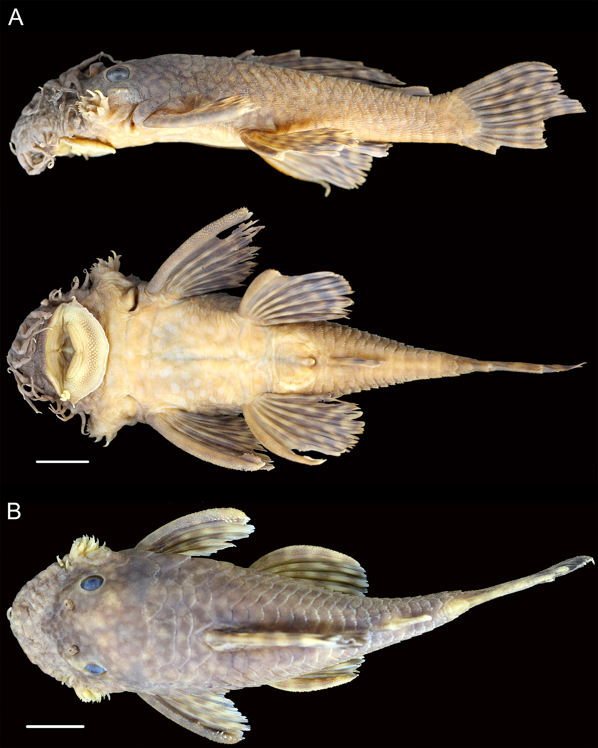
Comments. Ancistrus triradiatus is likely to represent several species. Specimens from the Guiana Shield tend to be colored more similarly to A. leucostictus with the few specimens available from the lower Caroni having large, but very faint, spots on the abdomen ( Fig. 27A View FIGURE 27 ). These specimens appear to grade into typical A. triradiatus in the west, however. Specimens in streams that drain into the Orinoco Delta and from streams that drain to the Caribbean directly, specimens from the Meta, and rare specimens in the Venezuelan llanos may have small, faint, light spots on the abdomen. Eigenmann (1918) describes the species as having spots on the abdomen, but Fowler (1943) states that the specimens he had available lacked spots. One of the paratypes does have very faint spots laterally on the abdomen, but none centrally located.
In addition, there are several specimens from the southwest corner of Venezuela that have particularly short pectoral fins and a lighter color than typical A. triradiatus ( Fig. 27B View FIGURE 27 ). We did not have enough specimens to determine if these were a variant or a different species.
Ancistrus gymnorhynchus is a species generally limited to the coastal drainages of Venezuela (the Tocuyo, Aroa, Yaracuy, Urama rivers and other small drainages), but are also present in the Río Pao, Orinoco River system ( Taphorn et al., 2010). The Pao specimens of A. gymnorhynchus are brown (vs. gray) and the Pao A. triradiatus (the dot just to the west of Lago Valencia in figure 7) have less intense spots on the fins than other specimens of A. triradiatus . It is possible that there has been introgression between the two species in this area. Unraveling further taxonomic structure in A. triradiatus will require extensive genetic information.


No known copyright restrictions apply. See Agosti, D., Egloff, W., 2009. Taxonomic information exchange and copyright: the Plazi approach. BMC Research Notes 2009, 2:53 for further explanation.
|
Kingdom |
|
|
Phylum |
|
|
Class |
|
|
Order |
|
|
Family |
|
|
Genus |
Ancistrus triradiatus Eigenmann 1918
| De, Lesley S., Taphorn, Donald C. & Armbruster, Jonathan W. 2019 |
Ancistrus triradiatus
| Eigenmann, C. H. 1922: 224 |
| Eigenmann, C. H. 1918: 680 |