
Anteon fisheri Olmi, 2003
|
publication ID |
https://doi.org/10.11646/zootaxa.4630.1.1 |
|
publication LSID |
lsid:zoobank.org:pub:8D375836-CCBA-473C-836F-6ABD44B4F881 |
|
DOI |
https://doi.org/10.5281/zenodo.3511645 |
|
persistent identifier |
https://treatment.plazi.org/id/03E987E2-FF2D-2ACB-FF3E-D56FFD16FA88 |
|
treatment provided by |
Plazi (2019-07-15 01:12:30, last updated 2024-11-28 23:15:01) |
|
scientific name |
Anteon fisheri Olmi, 2003 |
| status |
|
( Fig. 49C View FIGURE 49 )
Anteon fisheri Olmi 2003: 24 ; 2006: 37; Azevedo et al. 2010: 876; Olmi et al. 2016: 58 View Cited Treatment .
Description. ♂. Fully winged; body length 1.4–1.8 mm. Head black, except mandible testaceous; antenna brown; mesosoma black; metasoma brown; pro- and mesoleg testaceous; metaleg brown in holotype, testaceous in two further specimens from Madagascar, 19°08.31’S 44°49.41’E. Antenna filiform; antennomeres in following proportions: 8.5:5:5:5:5:5.5:5:5.5:5:7. Head shiny, punctate, unsculptured among punctures; vertex of head (ocellar triangle, temple and region behind lateral ocelli) dull and rugose; frontal line complete; occipital carina complete; POL = 5; OL = 3; OOL = 5; OPL = 1.5; TL = 3. Mesoscutum, mesoscutellum and metanotum shiny, punctate, unsculptured among punctures. Notauli incomplete, reaching approximately 0.25–0.50 × length of mesoscutum (0.25 × in the holotype; 0.5 × in two further specimens from Madagascar, 19°08.31’S 44°49.41’E). In specimen from South Africa, 34°16.481’S 19°01.033’E, notauli very short, hardly visible near anterior margin of mesoscutum. Metapectal-propodeal disc with strong transverse posterior keel, reticulate rugose, dull; propodeal declivity dull, reticulate rugose, with two longitudinal keels and median area as rugose as lateral areas. In specimen from South Africa, 29°19.1’S 30°15.5’E, propodeal declivity with left longitudinal keel; right longitudinal keel absent. Forewing hyaline, without dark transverse bands; distal part of 2r-rs&Rs vein much shorter than proximal part (3:6.5). Paramere ( Fig. 49C View FIGURE 49 ) without distal inner pointed process; tibial spurs 1/1/2.
♀. Unknown.
Material examined. Type: ♂ holotype: SOUTH AFRICA: Western Cape Prov., Table Mnt., Orange Kloof Nat. Reserve , 34°00’S 18°23.7’E, 125 m, 18.XII.1997, B.L. Fisher leg. GoogleMaps , 1546, sifted litter (leaf mold, rotted wood), montane rainforest (originally in CAS, now in SAMC). Other material: MADAGASCAR: Antsiranana, Ambato Forest , 26.6 km 33° NE Ambanja, 13°27.52’S 48°33.06’E, 150 m, 8.XII.2004, MT, rainforest, B.L. Fisher leg. GoogleMaps , BLF11518 , 1♂ ( CAS); Fianarantsoa, Ranomafana National Park, Vohiparara , 21°13.57’S 47°22.19’E, at broken bridge, 1110 m, 21–28.I.2002, MT, high altitude rainforest, R. Harin’Hala leg. GoogleMaps , MA-02-09A-13, 1♂ ( CAS); Fian- arantsoa, Ranomafana National Park, Belle Vue at Talatakely , 21°15.99’S 47°25.21’E, 1020 m, 19–26.II.2002, MT, secondary tropical forest, R. Harin’Hala leg. GoogleMaps , MA-02-09C-17, 1♂ ( CAS); same locality label, 28.XI–6.XII.2001, MA-02-09C-05 GoogleMaps , 2♂♂ ( CAS); same locality label, 12–19.II.2002, MA-02-09C-16 GoogleMaps , 1♂ ( CAS); same locality label, 16.X–8.XI.2001, MA-02-09C-01 GoogleMaps , 2♂♂ ( CAS, MOLC); Fianarantsoa, Ranomafana National Park , radio tower at forest edge, 21°15.05’S 47°24.43’E, 1130 m, 4–12.III.2002, MT, mixed tropical forest, R. Harin’Hala leg. GoogleMaps , MA-02- 09B-19, 2♂♂ (1 in CAS, 1 in MOLC); Mahajanga, Tsingy de Bemaraha National Park, 3.4 km 93° E Bekopaka, Tombeau Vazimba , 19°08.31’S 44°49.41’E, 50 m, 6–10.XI.2001, MT, tropical dry forest, Fisher, Griswold et al. leg., BLF 4233 GoogleMaps , 2♂♂ ( CAS, MOLC); Mahajanga, Ambatofolaka, Namoroka, 53 km from Soalala , 3 km N Vilanan- dro village, 16°28’04’’S 45°23’48’’E, 400 ft., 9–18.XII.2007, dense dry forest, MT, M. Irwin, R. Harin’Hala leg. GoogleMaps , MG-40A-11, 1♂ ( CAS); Mahajanga, Namoroka village, Befatika Andranovory , 16°28’04’’S 45°23’48’’E, 400 ft., 30.XI–9.XII.2007, dense dry forest, MT, M. Irwin, R. Harin’Hala leg. GoogleMaps , MG-40B-11, 1♂ ( CAS); same locality label, 9–16.XI.2007, MG-40B-08 GoogleMaps , 1♂ ( CAS); Toamasina, Zahamena National Park, Onibe River , 17°45’33’’S 48°51’17’’E, 780 m, 21–23.II.2009, rainforest, MT, BLF22168, B.L. Fisher et al. leg GoogleMaps ., 1♂ ( CAS); Toliara, Tsimanampetsotsa Nat. Park, Bemanateza Forest, 20.7 km 81°E Efoetse , 23 km 131° SE Beheloka, 23°59.32’S 43°52.50’E, 90 m, 22–26.III.2002, MT, in spiny forest thicket, Fisher, Griswold et al. leg., BLF 6257 GoogleMaps , 1♂ ( CAS); Toliara, Zombitse National Park , 19.8 km 84° E Sakaraha, 22°50.36’S 44°42.36’E, 770 m, 5–9.II.2003, MT, tropical dry forest, Fisher, Griswold et al. leg., BLF7506 GoogleMaps , 2♂♂ ( CAS); Toliara, Berenty Special Reserve , 8 km NW Amboasary, 25°00.40’S 46°18.20’E, 85 m, 16–27.XII.2002, MT, gallery forest, M. Irwin, F. Parker, R. Harin’Hala leg. GoogleMaps , MA- 02-22-10, 1♂ ( CAS). SOUTH AFRICA: KwaZulu-Natal, Karkloof , 1325 m, 29°19.1’S 30°15.5’E, 25.VII–25.IX.2005, MT, M. Mostovski leg. GoogleMaps , 1♂ ( NMSA); Royal Natal National Reserve, Mahai Camp , 28°41.27’S 28°56.86’E, 1450 m, 25.XI–12.XII.2005, MT, M. Mostovski leg. GoogleMaps , 1♂ ( NMSA); KwaZulu-Natal, Cathedral Peak Natural Reserve, Rain- bow Gorge , 28°57.60’S 29°13.61’E, 1480 m, 14.XII.2005 – 29.I.2006, MT, M. Mostovski leg. GoogleMaps , 3♂♂ ( NMSA); same locality label, 18.XI.2006 – 26.II.2007 GoogleMaps , 5♂♂ ( NMSA); Western Cape Prov., Walker Bay Nature Reserve , 34°27.41’S 19°21.39’E, 11.VIII–6.IX.1997, S. van Noort leg. GoogleMaps , 1♂ ( SAMC); same locality label, IX–XII.1997, MT, S. van Noort leg. GoogleMaps , 10♂♂ ( SAMC); same locality label, 17–31.V.1997, MT, S. van Noort leg. GoogleMaps , 11♂♂ ( SAMC); Western Cape Prov., Cape Town, Constantiaberg, Tokai Forest , pine plant, X–XI.1995, MT, S. van Noort leg. , 1♂ ( SAMC); Western Cape Prov., Grootvadersbosch Nature Reserve , 33°59.030’S 20°49.128’E, 340 m, 5.XI.2009 – 27.II.2010, MT, Afromontane Forest, S. van Noort leg. GoogleMaps , 1♂ ( SAMC); same locality label, 26.X.2010 – 26.I.2011, GVB10-FOR1-M07 GoogleMaps , 5♂♂ ( SAMC); same locality label, 11.XII.2012 – 26.I.2013, GVB10-FOR1-M14 GoogleMaps , 1♂ ( SAMC); Western Cape Prov., Kogelberg Nature Reserve, 34°16.481’S 19°01.033’E, 16.X–16.XI.1999, MT, Mesic Mountain Fynbos, last burnt c. 1978, S. van Noort leg. GoogleMaps , 6♂♂ ( SAMC); same locality label, 16.XI–16.XII.1999 GoogleMaps , 2♂♂ ( SAMC); same locality label, 16.II–16.III.1999 GoogleMaps , 1♂ ( SAMC); same locality label, 16.XI–16.XII.1998 GoogleMaps , 2♂♂ ( SAMC); Western Cape Prov., Koe- berg Nature Reserve , 33°37.622’S 18°24.259’E, 20.II–20.III.1998, MT, West Coast Strandveld, S. van Noort leg. GoogleMaps , 2♂♂ ( SAMC); Western Cape, Fynbos Estate, Dragonridge , 33°34.092’S 18°47.680’E, 635 m, 28.IX–28.XII.2010, MT, Boland Granite Fynbos, S. van Noort leg. GoogleMaps , DRA09-FYN1-M05, 1♂ ( SAMC). UGANDA: Western Region, Kabarole District, Kibale Forest, Kanywara ( RNHL); Western Region , Kabarole District, Kibale National Park , Kanyawara Makerere University Biological Field Station, 0°34.390’S 30°21.658’E, 1587 m, 4–26.VIII.2008, YPT, primary mid-altitude rainforest, near stream, S. van Noort leg. GoogleMaps , 1♂ ( SAMC) .
Hosts. Unknown.
Distribution. Madagascar, South Africa, Uganda.
Azevedo, C. O., Madl, M. & Olmi, M. (2010) A Catalogue of the Bethylidae, Chrysididae, Dryinidae, Embolemidae, Sclerogibbidae and Scolebythidae (Hymenoptera: Chrysidoidea) of the Malagasy Subregion. Linzer biologische Beitrage, 42, 845 - 918.
Olmi, M. (2003 [ 2001 ]) A contribution to the knowledge of Dryinidae (Hymenoptera Chrysidoidea). Frustula entomologica, New Series, 24, 21 - 49.
Olmi, M., van Noort, S. & Guglielmino, A. (2016) Contribution to the knowledge of Afrotropical Dryinidae, Embolemidae and Sclerogibbidae (Hymenoptera), with description of new species from Central African Republic and Uganda. ZooKeys, 578, 45 - 95. https: // doi. org / 10.3897 / zookeys. 578.7820
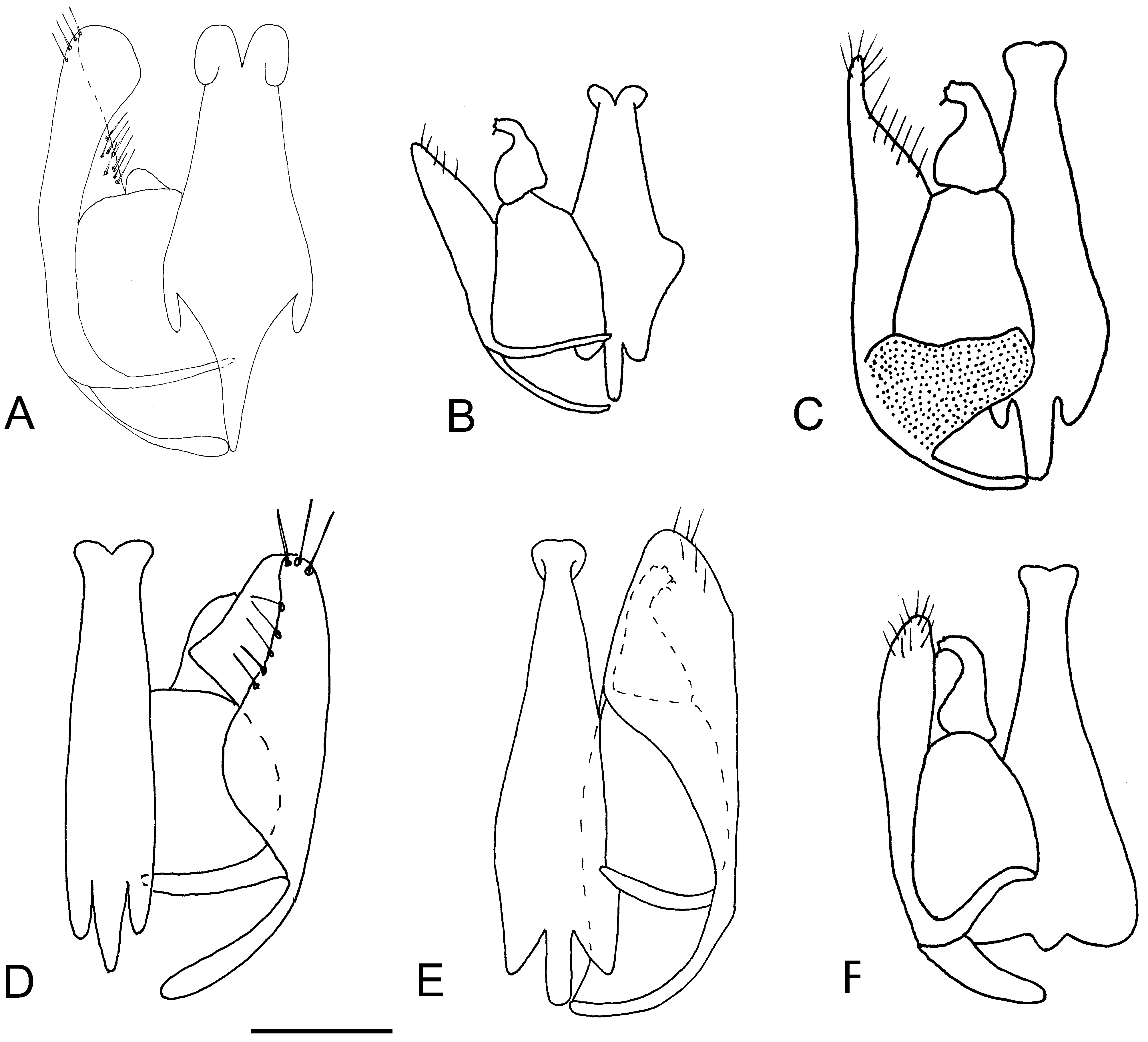
FIGURE 49. ♂ genitalia of Anteon species. A: A. fabulosum Olmi, holotype; B: A. felice Olmi & van Harten, ♂ from Ye- men, Ar-Rujum; C: A. fisheri Olmi, holotype; D, E: A. garambanum Olmi, holotype (D) and ♂ from Madagascar, 25°00.40’S 46°18.20’E; F: A. georgense Olmi, holotype. Scale bar: A: 0.10 mm; B, F: 0.11 mm; C, D, E: 0.07 mm.
No known copyright restrictions apply. See Agosti, D., Egloff, W., 2009. Taxonomic information exchange and copyright: the Plazi approach. BMC Research Notes 2009, 2:53 for further explanation.
|
Kingdom |
|
|
Phylum |
|
|
Class |
|
|
Order |
|
|
SuperFamily |
Chrysidoidea |
|
Family |
|
|
SubFamily |
Conganteoninae |
|
Genus |
Anteon fisheri Olmi, 2003
| Olmi, Massimo, Copeland, Robert S. & Noort, Simon Van 2019 |
Anteon fisheri
| Olmi, M. & van Noort, S. & Guglielmino, A. 2016: 58 |
| Azevedo, C. O. & Madl, M. & Olmi, M. 2010: 876 |
| Olmi, M. 2003: 24 |
1 (by plazi, 2019-07-15 01:12:30)
2 (by ImsDioSync, 2019-07-15 21:44:11)
3 (by ImsDioSync, 2019-07-17 21:37:11)
4 (by ImsDioSync, 2019-08-20 13:06:38)
5 (by ImsDioSync, 2019-08-20 13:21:13)
6 (by ImsDioSync, 2019-08-20 13:24:44)
7 (by plazi, 2019-09-13 11:06:40)
8 (by plazi, 2019-09-13 11:27:55)
9 (by plazi, 2019-09-13 11:40:48)
10 (by plazi, 2019-09-13 12:02:45)
11 (by plazi, 2019-09-13 12:10:21)
12 (by plazi, 2019-09-13 12:40:19)
13 (by plazi, 2019-09-13 12:56:04)
14 (by plazi, 2019-09-13 13:02:36)
15 (by plazi, 2019-09-13 13:12:32)
16 (by plazi, 2019-09-13 13:18:31)
17 (by plazi, 2019-09-13 13:23:49)
18 (by plazi, 2019-09-13 13:30:55)
19 (by plazi, 2019-09-13 13:45:25)
20 (by veselin, 2019-09-19 09:36:22)
21 (by ExternalLinkService, 2019-09-19 10:04:23)
22 (by ExternalLinkService, 2019-10-09 11:12:22)
23 (by ExternalLinkService, 2019-10-18 10:24:52)
24 (by ExternalLinkService, 2019-10-18 16:08:44)
25 (by ExternalLinkService, 2019-10-18 23:16:10)
26 (by ExternalLinkService, 2019-10-19 09:09:45)
27 (by ExternalLinkService, 2019-10-19 10:15:36)
28 (by ExternalLinkService, 2019-10-19 17:59:53)
29 (by ExternalLinkService, 2019-10-19 18:26:51)
30 (by ExternalLinkService, 2019-10-19 18:58:28)
31 (by ExternalLinkService, 2019-10-19 19:43:33)
32 (by ExternalLinkService, 2019-10-19 20:32:39)
33 (by ExternalLinkService, 2019-10-19 21:25:40)
34 (by ExternalLinkService, 2022-01-29 12:22:14)
35 (by GgImagineBatch, 2022-04-30 05:01:04)
36 (by ExternalLinkService, 2022-08-27 10:27:41)
37 (by ExternalLinkService, 2022-08-28 01:18:13)
38 (by ExternalLinkService, 2022-08-28 01:18:13)
39 (by ExternalLinkService, 2022-09-01 04:20:47)
40 (by plazi, 2023-10-30 16:33:09)
41 (by ExternalLinkService, 2023-10-31 08:31:47)
42 (by plazi, 2023-12-08 23:28:06)
43 (by karina, 2024-07-23 11:56:05)