
Thaumatodryinus merinus Olmi, 2004
|
publication ID |
https://doi.org/ 10.11646/zootaxa.4630.1.1 |
|
publication LSID |
lsid:zoobank.org:pub:8D375836-CCBA-473C-836F-6ABD44B4F881 |
|
persistent identifier |
https://treatment.plazi.org/id/03E987E2-FE2D-2BCD-FF3E-D312FB6FFB6B |
|
treatment provided by |
Plazi |
|
scientific name |
Thaumatodryinus merinus Olmi, 2004 |
| status |
|
5. Thaumatodryinus merinus Olmi, 2004
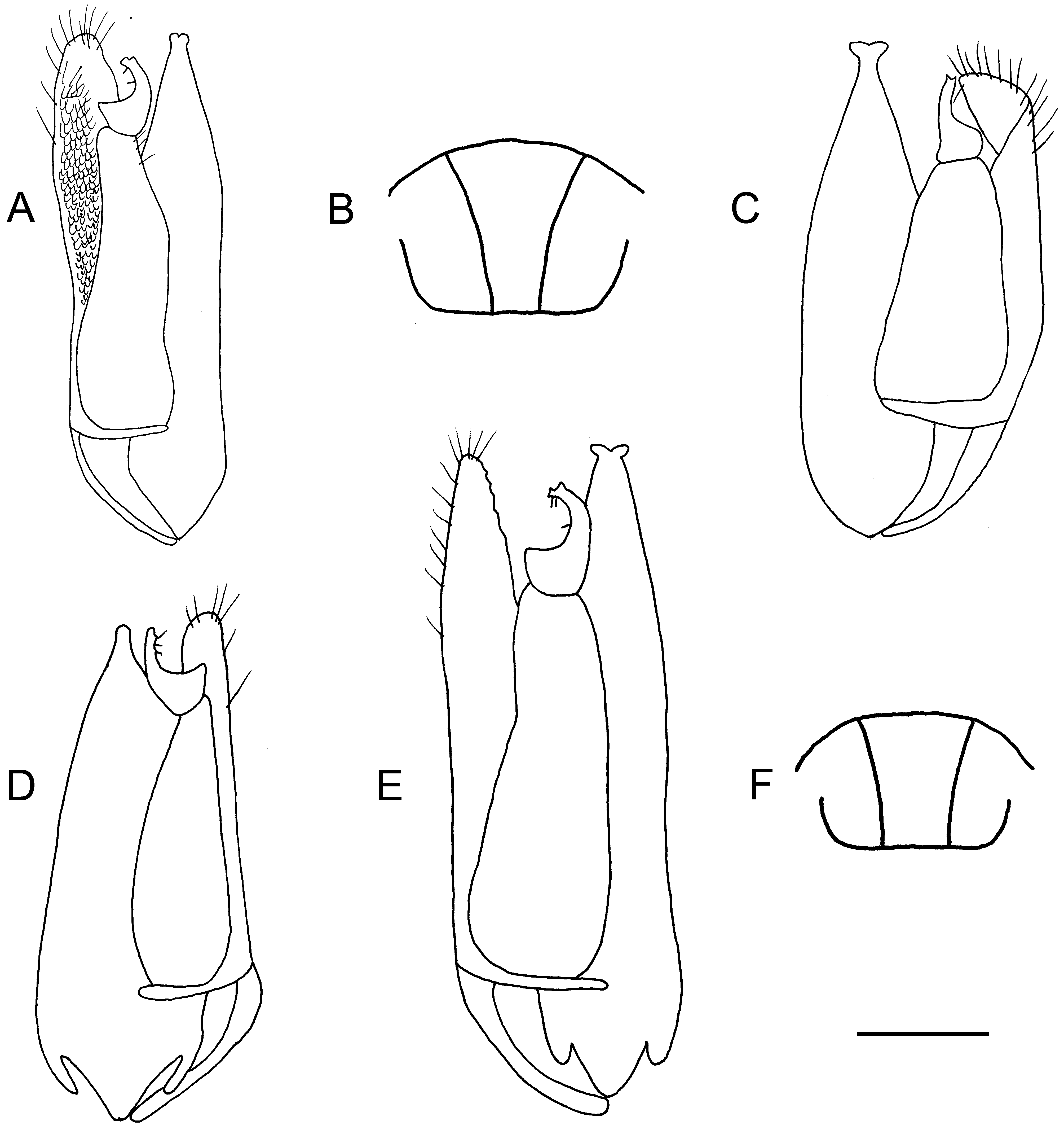
( Figs 157D View FIGURE 157 , 159B, C View FIGURE 159 )
Thaumatodryinus merinus Olmi 2004d: 99 ; Azevedo et al. 2010: 893.
Description. ♂ ( Fig. 157D View FIGURE 157 ). Fully winged; body length 2.2–3.0 mm. Head testaceous, except ocellar triangle black or brown; antenna testaceous-darkened, except antennomere 1 testaceous-light; mesosoma testaceous, except brown spot on anterior surface of mesoscutum; mesoscutellum and metanotum black or brown; large brown spot on metapectal-propodeal disc and propodeal declivity; anterior surface of mesopleuron and meso-metapleuron suture brown; metasoma brown; legs testaceous. Some specimens from Madagascar, 16°24.24’S 45°18.36’E, are more darkened, with part of occiput and entire mesopleuron and metapleuron brown. Occasionally mesosoma testaceous, except mesoscutum, mesoscutellum, part of mesopleuron and median region of propodeal declivity brown. In specimen from Madagascar, 16°41.49’S 44°31.41’E, head black, except mandible, clypeus, part of malar space and stripe between antennal toruli ferruginous-dark; antenna brown, except scape and pedicel testaceous; prothorax ferruginous-dark; mesoscutum totally black; rest of mesosoma black; metasoma brown; legs testaceous. In specimen from Madagascar, 23°13.351’S 43°52.853’E, head black, except mandible, clypeus, malar space and stripe along orbits testaceous, area between antennal toruli ferruginous-dark; antenna brown, except antennomere 1 testaceous; mesosoma black, except prothorax (dorsally brown), posterior third of mesoscutum and basal third of metapleuron testaceous; metasoma brown; legs testaceous. In specimen from Madagascar, 21°13.11’S, 45°19.26’E, head and mesosoma completely testaceous-reddish, except ocellar triangle and axilla brown. Antenna filiform; antennomeres in following proportions: 7:5:9:7:11:12:11:10:8:11. Head dull, convex, granulate and slightly rugose; frontal line absent; occipital carina complete; POL = 5.5; OL = 2; OOL = 6; OPL = 1; TL = 4; greatest breadth of lateral ocelli longer than OL (4:2). In dark specimens head with some irregular keels on frons. Mesoscutum dull, as sculpured as head (in dark specimens mesoscutum with some irregular keels). Notauli complete, posteriorly separated; minimum distance between notauli as long as greatest breadth of lateral ocelli (4:4), shorter than breadth of each lateral region of mesoscutum measured at posterior margin of mesoscutum ( Fig. 159B View FIGURE 159 ); in two specimens from Madagascar, 21°15.05’S 47°24.43’E, minimum distance between notauli longer than greatest breadth of lateral ocelli (4:3). Mesoscutellum shiny, punctate, unsculptured among punctures. Metanotum shiny, unsculptured. Metapectal-propodeal disc reticulate rugose, without strong transverse posterior keel; propodeal declivity reticulate rugose, without longitudinal keels. Forewing hyaline, without dark transverse bands; distal part of 2r-rs&Rs vein longer than proximal part (19:14); 2R1 cell open. Inner side of paramere without mosaic sculpture ( Fig. 159C View FIGURE 159 ); tibial spurs 1/1/2.
♀. Unknown.
Material examined. Types: ♂ holotype: MADAGASCAR: Antsiranana, Ankarana Special Reserve , 13.6 km 192° SSW Anivorano Nord, 12°51.49’S 49°13.33’E, 210 m, 16–20.II.2001 GoogleMaps , MT, tropical dry forest, Fisher, Griswold et al. leg., code BLF 3011, ( CAS). Paratypes: same locality label as holotype GoogleMaps , 9♂♂ ( CAS) , 2♂♂ ( MOLC). Other material: MADAGASCAR: Antsiranana, Diana Region, Orangea dry forest, Ramena, Baie de dune, 900 m E of Camp Minier , 15–22.VI.2011 , 12°13.97’S 49°21.99’E, M. Irwin, R.Harin’Hala leg., MT, dry forest, elev. 152 m, MG-62-27, 1♂ ( CAS); same locality label 23–31.III.2011 , 1♂ ( MOLC); Antsiranana, Orangea , 3 km E of Ra- mena near fort, 12°14.49’S 49°22.17’E, 65 m, 23–27.I.2001 GoogleMaps , MT, littoral forest on sand, MA- 01-05-02, M.E. Irwin, E.I. Schlinger & R. Harin’Hala leg., 4♂♂ ( CAS); Antsiranana, Sakalava Beach , 12°15.46’S 49°23.51’E, 10 m, 20–28.VII.2001 GoogleMaps , dwarf littoral forest, MT, across sandy trail, MA-01-04B-15, M.E. Irwin & R. Harin’Hala leg., 2♂♂ ( CAS); Antsiranana, 1 km W Sakalava Beach , 12°15.59’S 49°23.42’E, brushy area, 30 m, MT, M.E. Irwin, E.I. Schlinger & R. Harin’Hala leg., MA-01-04A-01 GoogleMaps , 2♂♂ ( CAS); Antsiranana, Ampondrabe Forest , 26.3 km 10° NNE Daraina, 12°58’12’’S 49°42’00’’E, 175 m, 10.XII.2003 GoogleMaps , MT, tropical dry forest, B.L. Fisher leg., BLF9976, 1♂ ( CAS); Antsiranana, Bekaraoka Forest , 6.8 km 60° ENE Daraina, 13°10.00’S 49°42.36’E, 150 m, 7.XII.2003 GoogleMaps , tropical dry forest, general collecting night spiders, B.L. Fisher leg., BLF9876, 7♂♂ (6 in CAS, 1 in MOLC); An- tsiranana, Montagne d’Ambre National Park , 12°30’52’’S 49°10’53’’E, 960 m, 19.III–6.IV.2001 GoogleMaps , MT, R. Harin’Hala leg., MA-01-01A-09, 1♂ ( CAS); same locality label, 11–12.II.2001 GoogleMaps , R. Harin’Hala leg., MA-01-01A-06, 1♂ ( CAS); Antsiranana, Montagne d’Ambre National Park , 12°31.13’S 49°10.45’E, 1125 m, 26.IV–12.IV.2001 GoogleMaps , MT, MA-01- 01D-09, R. Harin’Hala leg., 1♂ ( CAS); same locality label, 14–30.V.2001 GoogleMaps , MA-01-01D-11, 1♂ ( CAS); Antsira- nana, Montagne d’Ambre National Park , 12°31’S 49°11’E, 975 m, 19.III–5.IV.2001 GoogleMaps , MT, M.E. Irwin, E.I. Schlinger & R. Harin’Hala leg., MA-01-01B-07, 1♂ ( CAS); same locality label, 4–10.III.2001 GoogleMaps , MA-1-01B-06, 1♂ ( CAS); Antsiranana, Ambre Special Reserve , 3.5 km 235° SW Sakaramy, 325 m, 12°28.8’S 49°14.32’E, 26–31.I.2001 GoogleMaps , MT, tropical dry forest, BLF2661, Fisher, Griswold et al. leg., 1♂ ( CAS); Antsiranana, SAVA Region, Vohemar District, Antsahabelela rain forest, 9 km SW Daraina, Binara , 13°15.03’S 49°37.00’E, 182 m, 25.V–1.VI.2011 GoogleMaps , MT, in humid forest, M. Irwin, R. Harin’Hala leg., MG-58-34, 2♂♂ ( CAS, MOLC); same locality label, 16–23.II.2011 GoogleMaps , MG- 58-20, 1♂ ( CAS); Antsiranana, SAVA Region, Vohemar District, Andranotsimaty dry forest, 9 km NE Daraina, 13°10.17’S 49°42.04’E, 90 m, 19–26.XII.2010 GoogleMaps , MT, dry dense forest, M. Irwin, R. Harin’Hala leg., MG-57-12, 2♂♂ ( CAS); same locality label, 14–21.II.2011 GoogleMaps , MG-57-19, 2♂♂ ( CAS). Fianarantsoa, Ranomafana National Park , radio tower at forest edge, 21°15.05’S 47°24.43’E, 1130 m, 16.X–8.XI.2001 GoogleMaps , MT, mixed tropical forest, R. Harin’Hala leg., MA-02-09B-01, 3♂♂ ( CAS); Fianarantsoa, near Isalo National Park , in dry wash east of Interpre- tive Center, 22°37.60’S 45°21.49’E, 885 m, 6–14.XII.2002 GoogleMaps , MT, in open area, MA-02-11B-49, R. Harin’Hala leg., 1♂ ( CAS); Fianarantsoa, Ranomafana National Park, Belle Vue at Talatakely , 21°15.99’S 47°25.21’E, 1020 m, 26–31.III.2002 GoogleMaps , MT, secondary tropical forest, R. Harin’Hala leg., MA-02-09C-22, 1♂ ( CAS); Mahajanga, Tsingy de Bemaraha National Park, 2.5 km 62° ENE Bekopaka, Ankidrodroa River , 19°07.56’S 44°48.53’E, 100 m, 11– 15.XI.2001 GoogleMaps , MT, tropical dry forest on Tsingy , Fisher, Griswold et al. leg., BLF4345 , 2♂♂ ( CAS); Mahajanga, Namoroka National Park , 9.8 km 300° WNW Vilanandro, 16°28.00’S 45°21.00’E, 140 m, 4–8.XI.2002 GoogleMaps , MT, tropical dry forest, Fisher, Griswold et al. leg., BLF 6445, 9♂♂ (3 in CAS, 6 in MOLC); Mahajanga, Namoroka Na- tional Park , 16.9 km 317° NW Vilanandro, 16°24.24’S 45°18.36’E, 100 m, 12–16.XI.2002 GoogleMaps , MT, tropical dry forest, Fisher, Griswold et al. leg., BLF 6581, 7♂♂ ( CAS); Mahajanga, Namoroka National Park , 17.8 km 329° WNW Vilanandro, 16°22.36’S 45°19.36’E, 100 m, 8–12.XI.2002 GoogleMaps , MT, tropical dry forest, Fisher, Griswold et al. leg., BLF6508, 1♂ ( CAS); Mahajanga, Namoroka National Park , 16.40818S 45.31437E, 21–31.X.2016 GoogleMaps , MT, C. Ville- mant leg., 1♂ ( MNHN); Mahajanga, Namoroka National Park , 16.40494S 45.31294E, 21–31.X.2016 GoogleMaps , MT, C. Vil- lemant leg., 1♂ ( MNHN); Mahajanga, Namoroka National Park , 16.40682S 45.31377E, 21–31.X.2016 GoogleMaps , MT, C. Villemant leg., 2♂♂ ( MNHN); Mahajanga, Namoroka National Park , 21–31.X.2016 , MT, C. Villemant leg., 2♂♂ ( MNHN); Mahajanga, Beanka Forest Reserve , 50.2 km E Maintirano, 18°01’35’’S 44°03’02’’E, 250 m, 19– 26.X.2009 GoogleMaps , tropical dry forest on tsingy, MT, B.L. Fisher et al. leg., BLF22787 , 6♂♂ (5 in CAS, 1 in MOLC); Mahajanga, Analamanitra Forest , 14 km NE Misinjo, 15°55’S 45°57’E, 65 ft., 23–30.X.2007 GoogleMaps , MT, dense dry forest, M. Irwin, R. Harin’Hala leg., MG-38-06, 1♂ ( CAS); same locality label, 15–22.I.2008 GoogleMaps , MG-38-14, 1♂ ( CAS); same locality label, 2–9.X.2007 GoogleMaps , MG-38-03, 1♂ ( CAS); same locality label, 20.XI–4.XII.2007 GoogleMaps , MG-38-09, 3♂♂ ( CAS); same locality label, 22–29.I.2008 GoogleMaps , MG-38-15, 3♂♂ ( CAS); same locality label, 26.II–4.III.2008 GoogleMaps , MG-38- 20, 1♂ ( CAS); Mahajanga, Ambatofolaka, Namoroka, 53 km from Soalala , 3 km N Vilanandro village, 16°28’04’’S 45°23’’48’’E, 400 ft., 9–18.XII.2007 , dense dry forest, MT, M. Irwin, R. Harin’Hala leg., MG-40A-11, 1♂ ( CAS); Mahajanga, Paro, Ankarafantsika National Park, Ampijoroa Forest Station , 40 km 306° NW Andranotasica, 16°10’15’’S 46°49’38’’E, 130 m, 20.III–1.IV.2001 GoogleMaps , MT, tropical dry forest, Fisher, Griswold et al. leg., BLF3520, 2♂♂ ( CAS); Mahajanga, Bsalampy District, Analangidro dry forest, 7 km NE Besalampy, 16°41.49’S 44°31.41’E, 200 ft., 4–11.XI.2007 GoogleMaps , MT, dry forest on sand, M. Irwin & R. Harin’Hala leg., MG-41-07, 1♂ ( MOLC); Toliara, Andohahela National Park, Manantalinjo Forest, 33.6 km 63° ENE Amboasary, 7.6 km 99° E Hazofotsy , 24°49.1’S 46°36.36’E, 150 m, 12–16.I.2002 GoogleMaps , MT, spiny forest thicket, Fisher, Griswold et al. leg., BLF 4811, 2♂♂ ( CAS); Toliara, Andohahela National Park, Tsimelahy , parcelled II, 24°56.21’S 46°37.60’E, 180 m, 16–17.XII.2002 GoogleMaps , MT, transitional forest, M. Irwin, F. Parker & R. Harin’Hala leg., MA- 02-20-09, 8♂♂ (6 in CAS, 2 in MOLC); Toliara, Kirindy Forest , 15.5 km 64° ENE Marofandilia, 20°02.42’S 44°39.44’E, 100 m, 28.XI–3.XII.2001 GoogleMaps , MT, tropical dry forest, Fisher, Griswold et al. leg., BLF 4601, 2♂♂ ( CAS); Toliara, Kirindy Forest , 15.5 km 64° ENE Ma- rofandilia, 20°04.09’S 44°39.38’E, 30 m, 11–18.III.2009 GoogleMaps , MT, tropical dry forest, B.L. Fisher leg., BLF 18285_71 , 1♂ ( CAS); same locality label, 9–16.I.2008 , BLF18285_10 , 1♂ ( MOLC); same locality label, 27.II–5.III.2008 , BLF18285_17 , 1♂ ( CAS); Toliara, Kirindy Forest , 15.5 km 64° ENE Marofandilia, 20°04.07’S 44°39.34’E, 24– 31.XII.2008 GoogleMaps , B.L. Fisher , MT, tropical dry forest, el 30 m, BLF18284_60 , 1♂ ( CAS); same locality label, 25.III– 1.IV.2009 , BLF18284_73 , 1♂ ( CAS); same locality label, 14–21.I.2009 , BLF18284_63 , 1♂ ( CAS); Toliara, Antaf- oky, 23°28.43’S 44°03.51’E, 55 m, 25–28.I.2002 GoogleMaps , MT, Gallery forest , Frontier Project leg., MGF003 , 1♂ ( CAS); Toliara, Antafoky , 23°29.19’S 44°04.44’E, 60 m, 8–10.II.2002 GoogleMaps , MT, Gallery forest , Frontier Project leg., MGF006 , 1♂ ( CAS); Toliara, Antafoky , 23°28.44’S 44°03.56’E, 60 m, 25–28.I.2002 GoogleMaps , MT, Gallery forest , Frontier Project leg., MGF002 , 1♂ ( CAS); Toliara, Zombitse National Park , near national road, 22°50.43’S 44°43.87’E, 825 m, 5– 12.I.2002 GoogleMaps , MT, deciduous spiny forest, R. Harin’Hala leg., 2♂♂ ( CAS, MOLC); Toliara, Zombitse National Park , near ANGAP office, 22°53.19’S 44°41.53’E, 840 m, 15.X–9.XI.2001 GoogleMaps , MT, deciduous spiny forest, M.E. Irwin, F.D. Parker & R. Harin’Hala leg., MA-02-13A-01, 1♂ ( CAS); same locality label, 9–19.XI.2001 GoogleMaps , 4♂♂ (3 in CAS, 1 in MOLC); Toliara, Zombitse National Park , near national road, 22°50.43’S 44°43.87’E, 825 m, 15.X–9.XI.2001 GoogleMaps , MT, deciduous spiny forest, R. Harin’Hala leg., MA-02-13B-01, 2♂♂ ( CAS, MOLC); Toliara, Zombitse National Park , 19.8 km 84° E Sakaraha, 22°50.36’S 44°42.36’E, 770 m, 5–9.II.2003 GoogleMaps , MT, tropical dry forest, Fisher, Griswold et al. leg., BLF7506, 1♂ ( CAS); Toliara, Beza Mahafaly Reserve , parcelle I near research station, 23°41.19’S 44°35.46’E, 165 m, 1–8.II.2002 GoogleMaps , MT, dry deciduous forest, R. Harin’Hala leg., MA-02-14A-14, 4♂♂ (3 in CAS, 1 in MOLC); same locality label, 20–24.XII.2002 GoogleMaps , 1♂ ( CAS); same locality label, 25.XII.2001 GoogleMaps – 2.I.2002 GoogleMaps , 1♂ ( CAS); same locality label, 29.III–10.IV.2002 GoogleMaps , 1♂ ( CAS); same locality label, 8–15.II.2002 GoogleMaps , MA-02-14A-15, 1♂ ( CAS); Toliara, Beza Mahafaly Reserve, parcelle II near Bellevue , 23°41.39’S 44°34.53’E, 180 m, 1–8.II.2002 GoogleMaps , MT, spiny forest, R. Harin’Hala leg., MA-02-14B-14, 1♂ ( CAS); Toliara, Mikea Forest , NW of Manombo, 22°54.22’S 43°28.53’E, 30 m, 20–27.XI.2001 GoogleMaps , MT, deciduous dry forest, R. Harin’Hala leg., MA-02-18A-03, 1♂ ( CAS); same locality label, 23.IX–3.X.2002 GoogleMaps , MA-02-18A-34, 4♂♂ (3 in CAS, 1 in MOLC); same locality label, 11–24.II.2003 GoogleMaps , 17♂♂ (7 in CAS, 10 in MOLC); same locality label, 19.II–1.III.2002 GoogleMaps , 1♂ ( CAS); same locality label, 27.IV– 5.V.2003 GoogleMaps , MA-02-18A-53, 3♂♂ (2 in CAS, 1 in MOLC); same locality label, 6–16.I.2002 GoogleMaps , MA-02-18A-09, 1♂ ( CAS); Toliara, Mikea Forest , NW of Manombo, 22°54.80’S 43°28.93’E, 37 m, 8–18.III.2002 GoogleMaps , MT, spiny forest, M. Irwin & R. Harin’Hala leg., MA-02-18B-16, 1♂ ( CAS); Manombo , 22°48.25’S 43°45.50’E, 222 m, 23–28.IV.2004 GoogleMaps , MT, gallery forest, Frontier Wilderness Project, MGF099, 1♂ ( CAS); Toliara, Berenty Special Reserve , 8 km NW Amboasary, 25°00.40’S 46°18.20’E, 85 m, 16–27.XII.2002 GoogleMaps , MT, gallery forest, M. Irwin, F. Parker, R. Harin’Hala leg., MA-02-22-0, 1♂ ( CAS); same locality label, 7–17.III.2003 GoogleMaps , MA- 02-22-18, 2♂♂ ( CAS); same locality label, 15–25.II.2003 GoogleMaps , MA- 02-22-16, 1♂ ( CAS); same locality label, 17–26.I.2003 GoogleMaps , MA- 02-22-13, 2♂♂ ( CAS); same lo- cality label, 16–27.XII.2002 , MA- 02-22-10, 1♂ ( CAS); same locality label, 26.I–5.II.2003 , MA- 02-22-14, 2♂♂ ( CAS); Toliara, Berenty Special Reserve , 8 km NW Amboasary, 25°01.26’S 46°18.33’E, 35 m, 7–17.X.2004 GoogleMaps , MT, spiny forest, M. Irwin, F. Parker, R. Harin’Hala leg., MA-02-22A-28, 1♂ ( CAS); Toliara, Cap Ste Marie Special Reserve , 74 km S Tsihombe, 25°35.26’S 45°09.78’E, 37 m, 25.II–7.III.2003 GoogleMaps , MT, spiny bush, M. Irwin, F. Parker & R. Harin’Hala leg., MA- 02-23-18, 3♂♂ (2 in CAS, 1 in MOLC); Toliara, Ranobe , 23°02.783’S 43°36.617’E, 20 m, 27.X–2.XI.2003 GoogleMaps , MT, spiny forest thicket, MGF081, Frontier Wilderness Project, 2♂ m ♀ ( CAS); Toliara, Fiher- enana, 23°13.351’S 43°52.853’E, 65 m, 5–10.VIII.2003 GoogleMaps , MT, degraded riparian forest close to water, MGF076, Frontier Wilderness Project, 1♂ ( MOLC); Toliara, Fiherenana , 23°14.07’S 43°52.15’E, 50 m, 1–4.XII.2002 GoogleMaps , MT, degraded gallery forest, MGF051, Frontier Wilderness Project, 1♂ ( CAS); Toliara, Ifaty, near Hotel Paradisia , 23°10.78’S 43°37.01’E, 9 m, 26.V–5.VI.2002 GoogleMaps , in coastal dunes, MT, vegetation in sandy area, R. Harin’Hala leg., MA- 02-16-28, 9♂♂ ( CAS); Toliara, Makay Mts. , 21°13.11’S, 45°19.26’E, 500 m, 24.XI–12.XII.2010 GoogleMaps , MT, gallery forest, sandy soil, B.L. Fisher et al. leg., BLF25357 , 2♂♂ ( CAS, MOLC); Toliara, Makay Mts. , 21°20.32’S, 45°10.59’E, 410 m, 27–30.XI.2010 GoogleMaps , MT, gallery forest, sandy soil, B.L. Fisher et al. leg., BLF25354 , 3♂♂ ( CAS); Toliara, Makay Mts. , 21°18.36’S, 45°07.46’E, 590 m, 3.XII.2010 GoogleMaps , MT, dry forest, sandy soil, B.L. Fisher et al. leg., BLF25550 , 2♂♂ ( CAS); Toliara, Tsifota, 20 km N Manombo , 1 km E of Tsifota village, 22°49.08’S 43°22.36’E, 15 m, 30.X–9.XI.2008 GoogleMaps , MT, spiny forest, M. Irwin, R. Harin’Hala leg., MG-48-03, 1♂ ( CAS); same locality label, 29.XII.2008 GoogleMaps – 8.I.2009 GoogleMaps , MG-48-09, 1♂ ( CAS); same locality label, 14–24.II.2009 GoogleMaps , MG-48-14, 2♂♂ ( CAS); Toliara, Beroboka village , 45 km NE Morondava, 19°58.65’S 44°39.92’E, 420 ft., 3–11.VIII.2008 GoogleMaps , MT, Antsarongaza gallery forest, MG-45B-33, M. Irwin, R. Harin’Hala leg. , 2♂♂ ( CAS, MOLC); same locality label, 430 ft., 20– 28.IV.2008 , MG-45A-20, 1♂ ( MOLC); same locality label, 430 ft., 22–30.V.2008 , MG-45A-24, 2♂♂ ( CAS); same locality label, 420 ft., 28.IV–6.V.2008 , MG-45B-21, 1♂ ( CAS); Toliara, Ambohimahavelona village , 33 km NE of Tulear, 23°26.45’S 43°53.98’E, 46 m, 20–27.II.2009 GoogleMaps , MT, dry forest, M. Irwin, R. Harin’Hala leg., MG-50B-22, 1♂ ( CAS); Tsimanampetsotsa National Park, Mitoho Forest , 24°02.91’S 43°45.14’E, 120 m, 9–15.I.2009 GoogleMaps , MT, transitional forest, M. Irwin, R. Harin’Hala leg., MG-53C-12, 2♂♂ ( CAS). MAYOTTE: Mount Combani , 12°48’23’’S 45°09’11’’E, 370 m, 25.XI–4.XII.2007 GoogleMaps , rainforest, MT, B.L. Fisher et al. leg., BLF18635 , 1♂ ( CAS) .
Hosts. Unknown.
Distribution. Madagascar, Mayotte.
Remarks. It is possible that Thaumatodryinus merinus is the opposite sex of T. dentatus Benoit (because one ♀ and six ♂♂ have been collected in the same site in Mahajanga, 18°01’35’’S 44°03’02’’E, and 1 ♀ and 7 ♂♂ have been collected in the same site in Antsiranana, Bekaraoka Forest, 13°10.00’S 49°42.36’E).

No known copyright restrictions apply. See Agosti, D., Egloff, W., 2009. Taxonomic information exchange and copyright: the Plazi approach. BMC Research Notes 2009, 2:53 for further explanation.
|
Kingdom |
|
|
Phylum |
|
|
Class |
|
|
Order |
|
|
Family |
|
|
Genus |
Thaumatodryinus merinus Olmi, 2004
| Olmi, Massimo, Copeland, Robert S. & Noort, Simon Van 2019 |
Thaumatodryinus merinus
| Azevedo, C. O. & Madl, M. & Olmi, M. 2010: 893 |
| Olmi, M. 2004: 99 |