
Moenkhausia cotinho Eigenmann, 1908
|
publication ID |
https://doi.org/ 10.11646/zootaxa.4852.1.1 |
|
publication LSID |
lsid:zoobank.org:pub:301C1BCC-51F1-43E0-9774-85DC28741E10 |
|
DOI |
https://doi.org/10.5281/zenodo.4494279 |
|
persistent identifier |
https://treatment.plazi.org/id/03E97B7E-FF82-FF8A-7BC6-FF5DFE60FA11 |
|
treatment provided by |
Plazi |
|
scientific name |
Moenkhausia cotinho Eigenmann, 1908 |
| status |
|
Moenkhausia cotinho Eigenmann, 1908 View in CoL
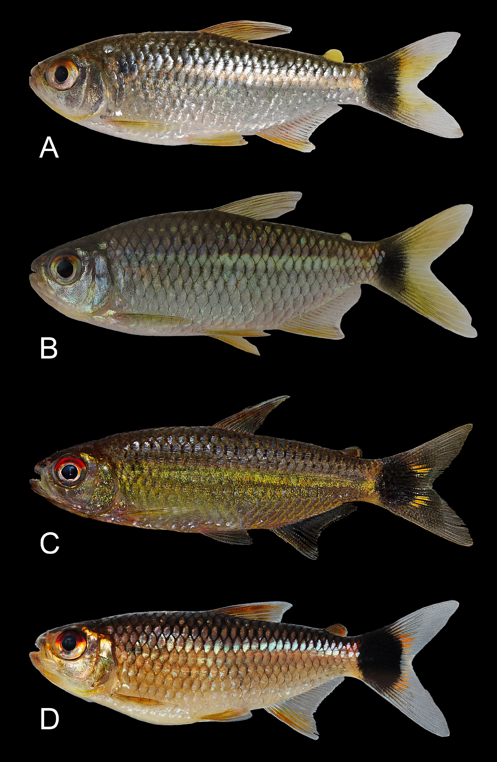
( Figs. 1–3 View FIGURE 1 View FIGURE 2 View FIGURE 3 )
Moenkhausia cotinho Eigenmann, 1908: 104 View in CoL [original description; type locality:“Para”]; Eigenmann, 1912: 68, 79, 97, 320–321, 327–328, 560, 569 [identification key; description]; Eigenmann, 1914: 26 [discussion about lateral-line]; Eigenmann, 1917: 46, 48, 50, 109–114, 525, pl. 9 fig. 1 [discussion about lateral line: footnote; identification key; description and distribution: Guyana and Brazil]; Roberts, 1967: 251, 251–259 [variation in extension of perforated lateral-line scales]; Géry, 1977: 439, 442–443, 594 [variation in extension of perforated lateral-line scales; identification key]; Fink, 1979: 11 [comparative material; Guyana: Potaro River]; Machado-Allison et al., 2000: 17 [listed (identification based on distribution); Venezuela: Río Cuyuní]; Lima & Toledo-Piza, 2000: 1062 [discussion about color pattern: comparative material; Brazil: rio Negro]; Vari & Harold, 2001: 8 [comparative material; Brazil: rio Negro]; Toledo-Piza, 2002: 136, fig. 37 [description by A. R. Wallace: rio Negro]; Lima et al., 2003: 146 [listed]; Géry & Zarske, 2004: 37 [listed; Brazil; rio Iriri]; Zarske & Géry, 2006: 9 [part: specimens from Guyana, based on distribution]; Castellanos & Sánchez-Duarte in Sanabria-Ochoa et al., 2007: 132, fig 156 [listed, description; Colombia: Río Vaupés]; Maldonado-Ocampo et al., 2008: 171 [listed; Colombia: Río Amazonas and Río Orinoco]; Benine et al., 2009: 161 [discussion about Moenkhausia oligolepis View in CoL / sanctaefilomenae View in CoL species complex]; Lasso et al., 2009: 104 [listed; Colombia: Río Atabapo]; Sousa et al., 2010: 262 [discussion about Moenkhausia oligolepis View in CoL /sanctaefiloemenae species complex, comparative material; Brazil: rio Maraú]; Marinho & Langeani, 2010: 9 [intraspecific variation of number of perforated lateral-line scales]; Bertaco et al., 2011: 61 [species of Moenkhausia View in CoL included in the Moenkhausia sanctaefilomenae View in CoL / oligolepis View in CoL group]; Castilho & Buckup, 2011: 245 [listed; Brazil, rio Xingú and rio Tapajós]; Casatti et al., 2013: 1500, table 2 [listed; Brazil: rio Machado]; Pastana & Dagosta, 2014: 393 [comparative material; Brazil; rio Tapajós]; Dagosta et al., 2015: 417, 423, fig. 5 [discussion about color pattern: comparative material; Brazil: rio Amazonas, rio Negro, rio Tapajós and rio Xingú]; Ohara & Marinho, 2016: 6 [discussion about color pattern: comparative material; Brazil: rio Amazonas, rio Negro, rio Tapajós, Xingu; Venezuela: Río Orinoco]; Soares & Bührnheim, 2016: 392 [intraspecific variation of number of perforated lateral-line scales]; Do Nascimiento et al. 2017: 51 [listed; Colombia: Río Amazonas and Río Orinoco]; Ohara, Lima, Salvador & Andrade, 2017: 214 [description, identification key; Brazil: rio Teles Pires]; Ohara, Mirande & Lima 2017: fig 6 [phylogenetic analysis]; Mirande, 2019: fig. 3 [phylogenetic analysis]; Dagosta & de Pinna, 2019: 45, 85 [discussion about geographic distribution patterns].
Knodus albolineatus Holly, 1929: 117 [original description; type locality: “Piquirão (Amazonasgebiet)”]; Ferreira & Lima, 2006: 637 [comparative material]; Zarske & Géry, 2006: 9 [as a synonym of Moenkhausia cotinho View in CoL ; description and morphometric data of type specimens].
Diagnosis. Moenkhausia cotinho is distinguished from all congeners, except M. australis , M. cosmops , M. diktyota , M. forestii , M. lineomaculata , M. oligolepis , M. parecis , M. pyrophthalma , M. sanctaefilomenae , M. pirahan sp. n., and M. uirapuru by the presence of a reticulate color pattern on body resulting from the presence of chromatophores forming a dark rim and delineating the posterior margin of the scales ( Fig. 4A View FIGURE 4 ), and the presence of a dark blotch on the base of the caudal fin (vs. absence of both the reticulate color pattern ( Fig. 4 View FIGURE 4 B-C), and dark blotch on the caudalfin base). Moenkhausia cotinho can be distinguished from M. cosmops , M. diktyota , M. forestii , M. pyrophthalma , and M. uirapuru by having a complete lateral line (except from some specimens from Guyana) (vs. lateral line incomplete); from M. parecis , M. oligolepis and M. sactaefilomenae by having 5/3 longitudinal series of scales, above and below the lateral line, respectively (vs. 5–7/4–6). Moenkhausia cotinho is distinguished from M. lineomaculata by the dorsal portion of the humeral blotch distinctly darker than the ventral portion (vs. humeral blotch evenly pigmented along its length). Although M. cotinho and M. lineomaculata both have longitudinal series of dark spots on the body, in M. cotinho the spots are distinctly smaller and more evident on the scales of the longitudinal series dorsal to the lateral line. In M. lineomaculata the spots are clearly larger and present on the scales of the middle portion of the body. In addition, those two species differ in the live coloration of the ventral portion of the iris (silvery in M. cotinho vs. blue in M. lineomaculata ). Moenkhausia cotinho is distinguished from M. pirahan by lacking light spots on the three dorsalmost longitudinal series of scales forming three interrupted stripes (vs. presence of light spots on the three dorsalmost longitudinal series of scales forming three interrupted stripes). Moenkhausia cotinho further differs from M. rondoni sp n. in the relatively shorter pectoral fin (its tip not extending beyond base of innermost pelvic-fin ray ( Fig. 5A View FIGURE 5 ) (vs. pectoral fin extending beyond base of innermost pelvic-fin ray; Fig. 5B View FIGURE 5 ) and in the presence of a longitudinal stripe extending from the vertical through the posterior margin of the humeral blotch (vs. longitudinal stripe extending from the vertical through the origin of the dorsal fin).
Description. Morphometric data presented in Table 1. Body compressed, moderately elongate. Largest specimen examined 65.8 mm SL; greatest body depth slightly anterior to dorsal-fin origin. Dorsal profile of head convex from snout tip to vertical through posterior nostril; straight to slightly convex from that point to tip of supraoccipital spine. Dorsal profile of body convex along pre-dorsal region; straight and posteriorly inclined along dorsal-fin base; posteriorly inclined to moderately convex to adipose fin; concave along dorsal margin of caudal peduncle. Ventral profile of head and body convex from tip of dentary to anal-fin origin; posterodorsally inclined along anal-fin base; concave along ventral margin of caudal peduncle. Mouth terminal, jaws equal. Posterior tip of maxilla at or slightly anterior to vertical through middle of orbit. Premaxillary teeth in two rows; outer row with 3*(5) or 4(43) tricuspid teeth, inner row with 4(1) or 5*(49) tri- to pentacupid teeth. Maxilla without teeth (26), with 1 tooth (8) or 2*(14) tricuspid teeth. Dentary with 5*(50) large pentacuspid teeth followed by a series of 8 diminute tricuspid teeth (3) ( Fig. 6 View FIGURE 6 ). Central median cusp of all teeth longer than lateral cusps. Branchiostegal rays 4(3). First gill arch with 8(3) rakers on hypobranchial, 18(2) or 19(1) rakers on ceratobranchial, 2(3) on intermediate cartilage, and 7(2), or 8(1) rakers on epibranchial.
Supraneurals 4(27) obliquely oriented. First supraneural anterior to neural spine of fifth vertebra, fourth supraneural between neural spines of seventh and eighth vertebrae. Origin of dorsal fin at approximately half of SL; first pteryogiophore of dorsal fin anterior to neural spine of ninth vertebra (3). Dorsal-fin rays ii 8(10), 9*(769) or 10(4); supernumerary dorsal-fin rays 1(3). Origin of anal fin at approximately 2/3 of SL, first pterygiophore of anal fin anterior to haemal spine of 16 th vertebra (3). Anal fin falcate. Anal-fin rays iv, 14(1), 15(3), 16(79), 17(293), 18(254), 19(129), 20(22) or 21(5). Pectoral-fin rays i, 11(7), 12(75), 13*(330), 14(286), 15(68) or 16(8), tip of longest ray of pectoral fin not extending beyond base of innermost pelvic-fin ray. Pelvic-fin origin anterior to vertical through dorsal-fin origin. Pelvic fin rays i, 7* (788), 8(2), longest ray of pelvic fin reaching urogenital opening. Caudal fin forked, principal caudal-fin rays on dorsal lobe i, 9(4), and on ventral lobe 8, i(4), dorsal procurrent caudal-fin rays 9(4), ventral procurrent caudal-fin rays 9(8). Adipose fin anterior to vertical through base of posteriormost anal-fin ray.
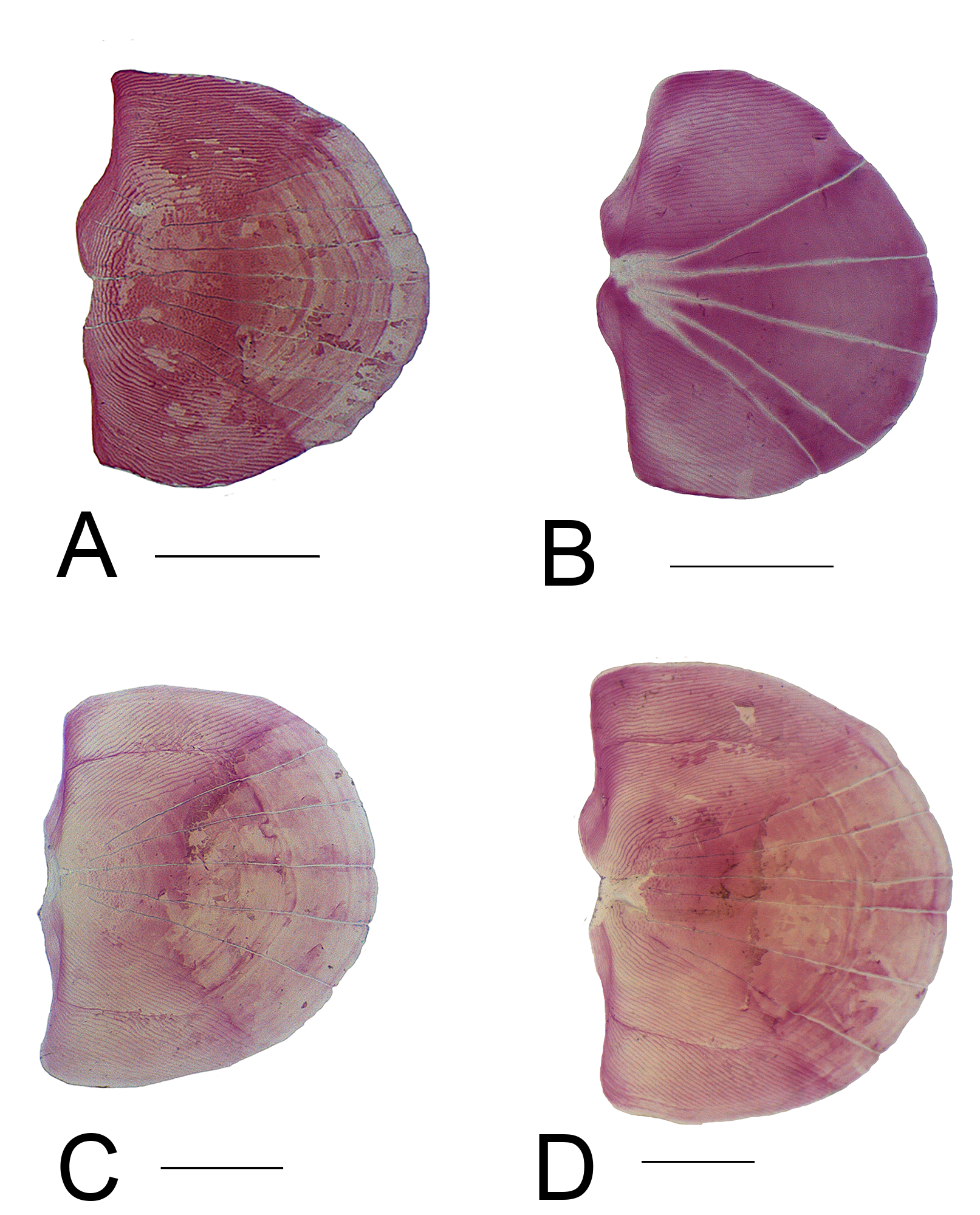
Scales cycloid with seven(1) or eight(3) radii moderately diverging from focus to posterior field of scale; conspicuous circulii present only in lateral fields ( Fig. 7A View FIGURE 7 ). Axillary scale present on pectoral and pelvic fins. Proximal one third of caudal-fin lobes covered by small scales. Lateral line complete. Lateral-line tube present on caudal fin posterior to last perforated scale. Pored lateral-line scales 27(2), 28(10), 29(20), 30(143), 31*(305), 32(221), 33(15) or 34(1). Longitudinal scale rows between dorsal-fin origin and lateral line 5*(775), longitudinal scale rows between lateral line and pelvic-fin origin 3*(779). Predorsal scales 9(129), 10*(563), 11(9) or 12(1). Middorsal scales between base of posteriormost dorsal-fin ray and adipose-fin origin 7(4), 8(162), 9*(565) or 10(23). Circumpeduncular scales 11(18), 12 (125), 13(27), 14*(290), 15(25) or 16(4). Total vertebrae 24(7) or 25(20), precaudal vertebrae 12(24) or 13(4) and caudal vertebrae 12(4) or 13(25).
Color in alcohol. Overall ground coloration of head and body yellowish to tan. Dorsal portion of head and body darker than ventral. Tips of upper and lower jaws dark. Infraorbitals with scattered dark pigmentation. Predorsal and preadipose scales dark, forming longitudinal line along dorsal midline of body. Posterior margin of scales delineated by chromatophores forming dark rim resulting in reticulate pattern on body, more evident on region dorsal of lateral line ( Fig. 4A View FIGURE 4 ). Scales of longitudinal rows on body with dark spots on posterior edge, more evident on rows dorsal to lateral line; spot on scales sometimes extending to anterior portion of adjacent scale. Humeral blotch vertically elongate, with dorsal portion covering horizontally approximately three scales and distinctly darker than ventral portion. Humeral blotch extending vertically on scales of four longitudinal rows. A longitudinal stripe extending from humeral blotch to caudal peduncle; stripe silver on specimens that retain guanine on body, dark on other specimens. A large blotch on base of caudal fin extending vertically to base of dorsal and ventralmost principal caudal-fin rays and not reaching tips of median caudal-fin rays. Caudal blotch preceded by light area on caudal peduncle. Middle portion of caudal-fin rays whitish and tips hyaline. Dorsal, anal, adipose, pectoral and pelvic fins mostly hyaline with few scattered chromatophores ( Figs. 2–3 View FIGURE 2 View FIGURE 3 ).
Color in life. Based on photographs of specimens shortly after collection. Overall ground coloration of head and body silvery, darker dorsally than ventrally, lateral portion of head and body iridescent yellow to orange in some specimens. Dorsal region of eyes red to orange. Dark pigmentation pattern of coloration in life similar to that described for preserved specimens except that humeral blotch is less marked than in preserved specimens due to presence of guanine on body. A silvery longitudinal stripe extending from humeral blotch to caudal peduncle. Middle portion of caudal fin rays, anterior rays of anal fin, dorsal, adipose, pelvic and pectoral fin rays, yellow to orange ( Fig. 1 View FIGURE 1 ).
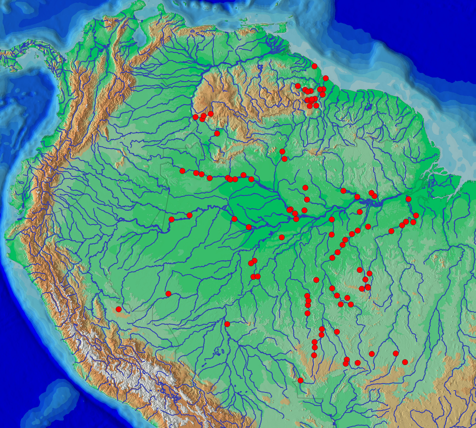
Distribution. Moenkhausia cotinho is widespread in the rivers of the Amazon and upper Río Orinoco basins and in the rivers of Guyana. It occurs in 21 of the regions proposed by Dagosta & de Pinna (2017) for the Amazon and neighboring regions (4. Upper Xingu, 5. Iriri, 6. Lower Xingu, 7. Teles Pires, 8. Juruena, 9. Tapajós, 10. Jamanxim, 12. Guaporé, 14. Middle-Lower Madeira, 15. Madeira Shield Tributaries, 16. Purus; 23. Negro, 24. Branco, 25. Urubu-Uatumã, 26. Trombetas, 27. Jari, 28. Amazonas main channel, 38. Essequibo, 39. Lower Orinoco, 40. Upper Orinoco) ( Fig. 8 View FIGURE 8 ).
Geographic variation. Specimens of Moenkhausia cotinho from the upper rio Negro, near São Gabriel da Cachoeira have the spot on the base of the caudal fin rounded and a relatively slender body. Specimens from rio Guaporé have the longitudinal stripe on body slightly curved dorsally. Some specimens from Guyana have incomplete lateral line and/or dentary and inner row of premaxillary teeth with seven cusps. Eigenmann (1917:110) reported that all specimens of M. cotinho from the Brazilian Amazon basin presented a complete lateral line, while specimens from some localities from Guyana (Crab Falls, Christianburg, Kunawaruk and Tumatumari) presented a gradual variation in number of perforated lateral line scales from eleven to a completely perforated lateral line. Furthermore, Eigenmann also noticed that specimens with incomplete lateral line presented different counts of perforated scales on each side of body. In the present study 88 specimens of M. cotinho examined by Eigenmann (1917) in the Guyana were examined: CAS 70765 (4 of 4) ; CAS 70766 (1 of 1) ; CAS 70767 (2 of 2) ; CAS 70768 (11 of 11) CAS 70769 (2 of 2) ; CAS 70770 (5 of 5) ; CAS 70771 (10 of 10) ; CAS 70772 (5 of 5) ; FMNH 7495 View Materials (2 of 2) ; FMNH 52875 View Materials (9 of 10) ; FMNH 52877 View Materials (5 of 5) ; FMNH 52879 View Materials (2 of 2) ; FMNH 52880 View Materials (6 of 6) ; FMNH 52882 View Materials (1 of 1) ; FMNH 52959 View Materials (5 of 5) ; FMNH 52996 View Materials (1 of 1) ; FMNH 52997 View Materials (2 of 2) ; FMNH 69712 View Materials (7 of 7) ; MCZ 30009 (2 of 2) ; MCZ 30010 (2 of 2) ; CAS-SU 21842 View Materials (2 of 2) ; CAS-SU 21858 View Materials (2 of 2). Of these, only 18 specimens have the lateral line incomplete, those from Tumatumari : CAS 70770 (4 of 5) and FMNH 52959 View Materials (1 of 5) and from Crab Falls : CAS 70772 (4 of 5) ; FMNH 52880 View Materials (4 of 6) ; FMNH 69712 View Materials (5 of 7), which presented between 13 to 17 perforated scales (from a total between 27–34 scales along the longitudinal series). In addition, 84 specimens of M. cotinho from the rivers of the Guyana collected more recently were also examined, and only 11 have an incomplete lateral line, ranging between 13 and 17 perforated scales, three from the Essequibo drainage : ROM 64148 (2 of 2) ; ROM 64149 (1 of 1), and nine from the Potaro drainage : ROM 61378 (1 of 2) ; ROM 96829 (2 of 1) ; ROM 96888 (1 of 1) ; ROM 96740 (1 of 1) ; ROM 96905 (2 of 3) ; ROM 969353 View Materials (1 of 6). In most cases, specimens with incomplete lateral lines (total of 29) are from the same lots of specimens with complete lateral lines (total of 143) and are not geographically separated from one another ).
From the 172 specimens of M. cotinho examined from rivers of the Guyana, 37 specimens present the teeth of the dentary and of the inner row of premaxilla with seven cusps: FMNH 52996 View Materials (1 of 1) ; FMNH 52882 View Materials (1 of 1) ; FMNH 52959 View Materials (1 of 5) ; FMNH 52880 View Materials (3 of 6) ; FMNH 25877 View Materials (5 of 5) ; FMNH 52875 View Materials (8 of 10) ; MZUSP 108877 View Materials (1 of 3) ( Fig. 9 View FIGURE 9 ) ; ROM 96905 (3 of 3) ; ROM 82845 (3 of 4) ; ROM 82855 (1 of 6) ; ROM 97546 (2 of 6) ; ROM 97505 (1 of 9) ; ROM 76802 (3 of 9) ; ROM 86752 (2 of 4) ; ROM 82865 (1 of 36). All other specimens from Guyana and other localities examined herein present no more than five cusps on those teeth .
There is no correlation between specimens from the Guyana with incomplete lateral lines and specimens with seven tooth cups, that is, there are specimens with seven cusps on the dentary and the inner row of pre-maxillary teeth with both incomplete and complete lateral lines. There are also specimens with five tooth cups on the dentary and the inner row of premaxillary teeth with both incomplete and complete lateral lines. All those specimens were morphologically very similar to the other specimens herein recognized as M. cotinho . Therefore, those specimens from the Guyana were tentatively identified as M. cotinho .
Remarks. Moenkahusia cotinho was originally proposed by Eigenmann (1908). The description was based on three specimens collected by the Thayer Expedition, in Pará and cited as cotypes by that author. Eigenmann also cited two additional specimens collected by Dr. Justa without specification of locality, but with the mention of “by Major Coutinho”. Lima et al. (2003:146) presumed that the locality of the specimens collected by Dr. Justa was rio Paraíba do Norte, João Pessoa, Paraíba state, but they pointed out that the locality is outside the known range of the species. In the present study, the presence of M. cotinho in the drainages of rio Paraíba do Norte was not confirmed. In addition, surveys of the freshwater ichthyofauna from northeastern Brazil, have so far failed to record the species ( Ramos et al. 2014; Silva et al. 2015; Rodrigues-Filho et al. 2016). Eigenmann (1917:73) mentioned that the type specimen of Moenkhausia justae and specimens of other species that were provided by Dr. Justa and had come through Major Coutinho, were from unknown localities, but probably originated from the surroundings of Manaus. Based on Eigenmann’s comments and on the currently known geographic distribution of Moenkhausia cotinho the two specimens from lot MCZ 21013, could have originated from the region of Manaus. One of the specimens, cited as cotype by Eigenmann (1908) is herein designated as lectotype (MCZ 21070, 55.4 mm SL) ( Fig. 3 View FIGURE 3 ), with the other two thus becoming paralectotypes (MCZ 174214, 54.7–56.4 mm SL). Specimens from lot MCZ 21013 have been considered as syntypes of M. cotinho (e.g. Lima et al. 2003:146; Lima et al. 2013: 309). However, in the original description of the species, those specimens were listed separately from those named as cotypes and following ICZN Article 72.4.6, they are excluded from the type series.
Knodus albolineatus Holly (1929) was described based on two syntypes from “Piquirão”, Pará state, Brazil, however this locality is uncertain, and the name could refer instead to a popular name, since “piquirão” is a common name for some characid fishes in some regions of Brazil. Zarske & Géry (2006) compared the syntypes of K. albolineatus with specimens of Moenkhausia cotinho from drainages of Guyana and concluded that Knodus albolineatus is a synonym of M. cotinho . The syntypes of K. albolineatus were not examined in the present study, However, the morphometric and meristic data of K. albolineatus presented by Zarske & Géry (2006:10) overlap those of M. cotinho . The description of the coloration pattern of K. albolineatus by Holly (1929) and Zarske & Géry (2006) did not include the black spot on the base of caudal fin, however the syntype (NMW 83365) illustrated in Zarske & Géry (2006, fig. 6) has the the dark spot on the base of the caudal fin. Zarske & Géry (2006) examined 48 specimens from arroyo Chaparina, Yacuma-Maniqui-basins Bolivia, which they identified as M. cotinho . Those specimens were not examined in the present study, however based on distribution information they probably are specimens of Moenkhausia rondoni , pending further examination to confirm their identification. Although we did not examine specimens from Colombian drainages, M. cotinho has been reported in that region (e.g. Castellanos & Sánchez-Duarte (2007); Maldonado-Ocampo et al. 2008, Lasso et al. 2009). The identification could be confirmed in the study of Castellanos & Sánchez-Duarte (2007: 132, fig. 156).
Type material: MCZ 21070 (55.4 mm SL), “Para, Brazil ”, Thayer Expedition to Brazil, 1865. Lectotype of Moenkhausia cotinho by present designation. MCZ 174214 View Materials (2, 54.7–56.4 mm SL), same data as lectotype. Paralectotypes .
Non-type material: Brazil: Acre, rio Purus basin: INPA 28516 (2-8, 28.6–39.2 mm SL), Igarapé Macapá, tributary of left margin of rio Purus, 8°45’15”S 69°28’28”W; H. D. B. dos Anjos, 26 Oct 2004. Amazonas, rio Amazonas: INPA 33392 (3-3, 31.5–33.9 mm SL), Ressaca Geral, 3°57’8”S 63°41’6”W, L. Rapp Py-Daniel, 13 Sep 2003; INPA 39025 (4-8, 40.4–46.9 mm SL), stream in front of community Floresta Amazônica, 3°23’49”S 69°14’43”W, R. R. de Oliveira et al. 24 Mar 2009; INPA 40913 (4-78, 39.4–42.2 mm SL), rio Coari Grande, at terminal area of oil pipeline Urucu-Tefé–Petrobras, J. Zuanon, 5 Mar 1991. MZUSP 7274 (9-9, 51.3–59.3 mm SL), Igarapé at rio Maraú, 3°24’S 57°42’W, EPA, 3 Dec 1967; Amazonas, rio Madeira basin: INPA 26721 (5-6, 33– 36 mm SL), Igarapé Inferno, rio Sucunduri, 7°48’18”S 58°54’1”W, L. Rapp Py-Daniel, 1 Jul 2006; INPA 33688, (2-5, 40,6–41,8 mm SL), rio Guariba - Resex Guariba, 8°42’42”S 60°25’53”W, W. Pedroza, W. Ohara, F. Ribeiro & T. Teixeira, 6 Nov 2008; UFRO 15402 (6-19, 36.9–40.4 mm SL), mouth of the long lake of rio Ipixuna, 7°30’37”S 63°2’24”W, W. M. Ohara; INPA 26192 (1, 36.1 mm SL), Igarapé do Mureru, community Terra Preta, rio Sucunduri, 7°45’45”S 58°49’0”W; L. Rapp Py-Daniel, 29 Jun 2006; Amazonas, rio Negro basin: INPA 9778 (5-23, 49.8–54.5 mm SL), rio Carabinani, Igarapé Boa Vista, Nova Arão, A. Negrão & C. Oliveira, 15 Oct 1993; INPA 15895 (1-1, 40.5 mm SL), rio Tarumã Açu, Manaus A. Kirovsky, 10 Sep 1993; INPA 15780 (1-1, 56.1 mm SL), Lago Cuniã, port of ICMBIO, A. Kirovsky, 8 Sep 1993; INPA 37868 (3-4, 48– 57.8 mm SL), rio Aiuanã, Santa Isabel do Rio Negro, 0°35’24”S 64°55’10”W, R. Rayla, P.M. Ito, Agenor & Juca, 3 Apr 2012; INPA 38928 (1-1, 26.1 mm SL), rio Daraá, near the mouth, Santa Isabel do Rio Negro, 0°27’21”S 64°46’36”W, J. Zuanon, H. Espirito-Santo & R. Leitão, 5 Apr 2012; INPA 37752 (2-2, 51.9–56.9 mm SL, Cachoeira Daraá, rio Darahá, Santa Isabel do Rio Negro, 0°25’26”S 64°46’20”W, R. R. Oliveira, R. R. Silva, P.M. Ito & Agenor, 29 Mar 2012; INPA 39471 (1-1, 46.2 mm SL), Manaus, Praia do Alemão, left margin of rio Negro, 2°58’S 60°21’W, J. Zuanon & M. Garcia, 2 Nov 1992; INPA 42833 (1-1, 42.6 mm SL), São Gabriel da Cachoeira, rio Negro, 0°2’56”N 67°16’32”W, L. Rapp Py-Daniel, D.A. Bastos, et al. 2 Dec 2013; INPA 42902 (6-12, 42.2–48.1 mm SL), rio Negro, São Gabriel da Cachoeira, 0°0’1”N 67°12’23”W, D.A. Bastos, et al. 3 Dec 2013; INPA 49399 (1-1, 49.4 mm SL), rio Negro, Cachoeira do Curucuí, São Gabriel da Cachoeira, 0°8’14”S 67°5’0”W, A.S. Oliveira, 18 Sep 2015; INPA 49745 (11-15, 46.7–59.1 mm SL), rio Curicuriari, in front of Community Inebu, São Gabriel da Cachoeira, 0°14’46”S 67°3’18”W, D. A. Bastos 27 Feb 2015; INPA 49794 (1-1, 43.3 mm SL), rio Negro, beach of island of community Maecês, São Gabriel da Cachoeira, 0°10’18”S 66°51’13”W, D. A. Bastos & A.G. Bifi, 18 Sep 2015; INPA 51625 (3-3, 47.4–50.3 mm SL), rio Preto, Santa Isabel do Rio Negro, 0°6’12”S 64°5’38”W, J. Zuanon, P.M. Ito, G.G. Barros, P. Guarido & Arnóbio, 22 Sep 2014; INPA 52165 (2-20, 18.5–22.1 mm SL), rio Negro, Archipelago of Anavilhanas, 2°43’5”S 60°45’16”W, Equipe de Ictiologia do INPA, 28 Feb 1976; INPA 249767 (2-2, 45.3–48.8 mm SL), rio Miuá, igarapé do Miuá 2, São Gabriel da Cachoeira, 0°7’16”S 66°52’20”W, A.S. Oliveira, L. Rapp Py-Daniel, I.M. Soares, 28 Feb 2015; INPA 533011 (2-2, 43.8–46.6 mm SL), rio Negro at Praia do Araá, Parque Nacional de Anavilhanas, 2°36’49”S 60°57’19”W, J. Birindelli, F. Jerep, L. Rapp Py-Daniel, D. Bastos & R. Ota. MCZ 21013 (1, 46.3 mm SL), locality uncertain (most probably region of Manaus, see under Discussion of species accounts), Thayer Expedition to Brazil, 1 Aug 1865; MPEG 370 (1-1, 47 mm SL), Barcelos, rio Negro, lake of island, 1°S 62°42’W, M. Goulding, 29 Jan 1980; MPEG 371 (2-2, 41– 43.9 mm SL), rio Negro, Anavilhanas, 2°40’S 60°40’W, M. Goulding, 1 Feb 1982; MPEG 372 (1-1, 37.6 mm SL), rio Negro, Anavilhanas, 2°40’S 60°40’W, M. Goulding, 21 Nov 1979; MPEG 374 (4-21, 25.4–36.3 mm SL), rio Negro, below rio Daraá, lago central, Santa Isabel do Rio Negro, 0°30’S 64°40’W, M. Goulding, 17 Feb 1980; MPEG 375 (1-3, 36.2 mm SL), rio Negro, Ilha de Tamaquaré, 0°30’S 64°55’W, M. Goulding, 10 Oct 1979; MPEG 376 (4-6, 32.7–34.5 mm SL), rio Negro, above rio Urubaxi, 0°30’S 63°30’W, M. Goulding, 4 Feb 1980; MPEG 377 (3-5, 28.4–37.1 mm SL), rio Negro, below rio Daraá, 0°30’S 64°40’W, M. Goulding, 12 Feb 1980; MZUSP 16961 (3-4, 52.2–55.6 mm SL), rio Uaupés, Taracuá, 0°6’N 68°28’W, A. B. Machado & P. Pereira, Aug 1964; MZUSP 17529 (4-4, 45– 48.5 mm SL), Igarapé of Cachoeira Cuiauá, left margin of rio Içá, Santo Antônio do Içá, 3°6’S 67°57’W, EPA, 18 Oct 1968; MZUSP 29825 (5-7, 19.3–37.3 mm SL), rio Negro, Anavilhanas, (igapó), 2°40’S 60°39’W, M. Goulding, Apr 1982; MZUSP 29826 (3-7, 40.6–49.3 mm SL), rio Negro, just below of rio Daraá, Santa Isabel do Rio Negro, 0°28’S 64°45’W, M. Goulding, 16 Nov 1980; MZUSP 29828 (8-11, 38.7–44.9 mm SL), rio Negro, Ilha de Tamaquaré, (lago central), Santa Isabel do Rio Negro, 0°30’S 64°55’W, M. Goulding, 11 Oct 1979; MZUSP 29831 (10-13, 34– 42.8 mm SL), rio Negro, Massarabi, Santa Isabel do Rio Negro, 0°25’S 66°30’W, M. Goulding, 18 Oct 1979; MZUSP 29832 (11-11, 33.3–52 mm SL), rio Negro, confluence of rio Urubaxi, 0°35’S 64°49’W, M. Goulding, 11 Feb 1980; MZUSP 29835 (1-2, 47.2 mm SL), rio Daraá, Cachoeira do Aracu, 0°30’S 64°45’W, M. Goulding, 10 Nov 1980; MZUSP 30278 (1-1, 30.2 mm SL), rio Negro, Ilha de Buiu-açu, Barcelos, 0°30’S 64°49’W, M. Goulding, 6 Feb 1980; MZUSP 31144 (2-2, 42.4–49 mm de CP), rio Negro, Ilha de Tamaquaré, 0°30’S 64°55’W, M. Goulding, 7 Feb 1980; MZUSP 50087 (3-3, 49.3– 31.5 mm SL), rio Negro, São João, near Tapurucuara (= Santa Isabel do rio Negro), 0°24’S 65°1’W, EPA, 24 Oct 1972; MZUSP 55125 (20-40, 48.8– 29.3 mm SL), Igarapé in São João, near Tapurucuara (=Santa Isabel do Rio Negro), 0°28’S 65°32’W, EPA, 27 Oct 1972; MZUSP 57501 (2-3, 34– 35.5 mm SL), Paricatuba, lagoon at margin of rio Negro, 0°31’S 65°1’W, EPA, 11 Nov 1972; MZUSP 58335 (6-8, 21.7–38.8 mm SL), channel between lakes in São João, near Tapurucuara (=Santa Isabel do Rio Negro), EPA, 24 Oct 1972; MZUSP 59219 (41-57, 47.7– 28.8 mm SL), Santa Isabel do Rio Negro, rio Negro, Paricatuba, 0°31’S 65°1’W, EPA, 10 Nov 1972; MZUSP 59963 (39-43, 22.9–49.9 mm SL), pool on beach, rio Negro, Tapera, 0°12’S 64°3’W, EPA, 03 Sep 1972; MZUSP 61923 (6-12, 23.7–39.8 mm SL), rio Aiuanã, near Santa Isabel do rio Negro, 0°24’S 65°1’W, EPA, 22 Oct 1972; MZUSP 62137 (6-6, 30.9–37.4 mm SL), lagoon in island of rio Negro, Paricatuba, 0°31’S 65°1’W, EPA, 14 Nov 1972; MZUSP 62193 (1-1, 30.3 mm SL), channel of lake in São João, near Tapurucuara (=Santa Isabel do rio Negro), 0°24’S 65°1’W, EPA, 25 Oct 1972; MZUSP 91591 (1-1, 51.4 mm SL), rio Uaupés (precise locality unknown), J. Chernela; MZUSP 95252 (4-5, 31.6–36 mm SL), Santa Isabel do Rio Negro, Lagoon at margin of rio Negro, Paricatuba, 0°31’S 65°1’W, EPA, 11 Nov 1972; MZUSP 100373 (1-1, 23.7 mm SL), Barcelos, stone pool at margin of rio Negro, 0°12’S 64°3’W, EPA, 01 Nov 1972; MZUSP 109449 (26-26, 21– 51.9 mm SL), Santa Isabel do Rio Negro, igapó in igarapé tributary of rio Jaradi, near confluence of rio Jaradi and rio Marauiá, 0°22’44”S 65°12’39”W, M. Toledo-Piza, O. Oyakawa, G. Mattox, M. Marinho & D. Santana, 6 Feb 2011; MZUSP 109933 (34-68, 35– 53.8 mm SL), Santa Isabel do Rio Negro, Igarapé Campo Grande, community Campo Grande, tributary of left margin of rio Negro, 0°25’51”S 64°56’45”W, M. Toledo-Piza, O. Oyakawa, G. Mattox, M. Marinho & D. Santana; MZUSP 109594 (13-29, 21.1–55.6 mm SL), rio Neuixi, near confluence of rio Negro, 00°21’45”S 65°05’13”W, M. Toledo-Piza, O. Oyakawa, G. Mattox, M. Marinho & D. Santana, 8 Feb 2011; MZUSP 109654 (1-4, 27.5 mm SL), rio Jurubaxi, in front of community São Francisco, just above confluence of rio Negro, 0°31’29”S 64°49’22”W, M. Toledo-Piza, O. Oyakawa, G. Mattox, M. Marinho & D. Santana, 09 Feb 2011; MZUSP 109479 (1-1, 43.9 mm SL), Santa Isabel do Rio Negro, igarapé tributary of rio Negro, downstream to the mouth of rio Jaradi, 0°24’10”S 65°11’30”W, M. Toledo-Piza, O. Oyakawa, G. Mattox, M. Marinho & D. Santana, 06 Feb 2011; MZUSP 109884 (1-1, 45.6 mm SL), mouth of rio Marauiá, confluence of rio Jaradi, 0°23’33”S 65°12’18”W, M. Toledo-Piza, O. Oyakawa, G. Mattox, M. Marinho & D. Santana, 5 Feb 2011; INPA 49384 (4-9, 45.5–48.3 mm SL), rio Negro, Cachoeira of Curucuí, São Gabriel da Cachoeira, 0°8’14”S 67°5’0”W, A.S. Oliveira, 12 Aug 2014; INPA 49718 (4-7, 48.5–53.7 mm SL), rio Curicuriari, in front of community Inebu, São Gabriel da Cachoeira, 0°14’43”S 67°0’59”W, A.S. Oliveira, L. Rapp Py-Daniel, I.M. Soares, 27 Feb 2015; MZUSP 125781 (1, 38.8 mm SL), Santa Isabel do Rio Negro, Igarapé Tibarrá, ca 1.5 hour above mouth, right margin, 0°24’07”S 64°56’31”W, M.Toledo-Piza, G. Mattox, M. Marinho, R. Britz; MZUSP 125782 (3, 41.6–43.7 mm SL), Santa Isabel do Rio Negro, rock plateau and beach, above mouth of Rio Urubaxi, 0°31’15”S 64°51’00”W, M.Toledo-Piza, G. Mattox, M. Marinho, R. Britz; MZUSP 125783 (2, 28.1- 30.5 mm SL), Santa Isabel do Rio Negro, margin of island, ca. 20 min by boat, above mouth of rio Urubaxi, 0°30’39”S 64°51’43”W, M.Toledo-Piza, G. Mattox, M. Marinho, R. Britz; MZUSP 125784 (4, 36.2–46.3 mm SL), Santa Isabel do Rio Negro, rio Daraá, 10 min. by boat below first rapids, left margin, 0°25’32”S 64°46’00”W, M.Toledo-Piza, G. Mattox, M. Marinho, R. Britz; MZUSP 125785 (16, 36.2–48.1 mm SL), Santa Isabel do Rio Negro, Igarapé Tibarrá, tributary of left margin of Rio Negro, ca. 1.5 h upstream of Santa Isabel do Rio Negro, at Tibarrá community, near harbor, 0°25’51”S 64°56’46”W, M.Toledo-Piza, G. Mattox, M. Marinho, R. Britz. Amazonas, rio Preto da Eva basin: INPA 30646 (1-1, 48.2 mm SL), rio Preto da Eva, 2°44’27”S 59°40’17”W, L.N. Carvalho, 29 Sep 2005; Amazonas, rio Purus basin: INPA 42083 (5-6, 39.4–46.2 mm SL), Igarapés dos Mutuns, Ipixuna, 6°22’30”S 63°16’29”W, T. Couto & M. Carvalho, 17 Aug 2012; INPA 35894 (1-1, 49.3 mm SL), interfluvium Purus/Madeira, Borba, 4°43’41”S 61°16’44”W. A. Galuch, et al., 18 Jul 2007; INPA 35910 (1-1, 56.9 mm SL), interfluvium Purus/Madeira, Borba, 4°41’30”S 61°18’32”W, A. Galuch et al., 19 Jul 2007; INPA 42156 (3-3, 36.7–44.5 mm SL), Flona Ipixuna, Igarapé dos Mutuns, 6°22’24”S 63°16’27”W, T. Couto & M. Carvalho, 18 Aug 2012; INPA 42389 (1-1, 40 mm SL), rio Ipixuna, Floresta Tapauá, 6°33’36”S 63°31’2”W, G. Barros & D. Mendes, 7 Oct 2013; INPA 42722, (2-2, 40.4–43.4 mm SL), rio Ipixuna, Floresta Tapauá, 6°33’36”S 63°31’20”W, G. Barros & D. Mendes, 16 Oct 2013; UFRO 15333 (2-2, 37.9–39.7 mm SL), rio Ipixuna, in front of rio Purus, 7°32’1”S 63°21’5”W, W. M. Ohara; INPA 34711 (1-1, 29.6 mm SL), community São Bernardo, 4°29’22”S 57°42’40”W, R. de Oliveira & W. Pedrosa, 28 May 2010; Amazonas, rio Solimões basin: INPA 51045 (1-1, 37.9 mm SL), rio Solimões - Lago Cemitério, 3°22’15”S 60°16’6”W, J. Santos, D. Campos, Astrogildo & Agenor, 4 Oct 2012; MZUSP 102756 (2-2, 33.5–34.3 mm SL), between Lago Murumuru and Lago Paraná do Janauacá, P. Bayley, 22 Jun 1977; Amazonas, rio Tefé basin: MZUSP 77138 (1-1, 45.3 mm SL), rio Tefé, Vista Escura, beach, 3°22’S 64°43’W, M. Goulding, 4 Aug 1979; MZUSP 73420 (1-2, 48.4 mm SL), rio Tefé, Jurupari, 3°22’S 64°43’W, M. Goulding, 1 Aug 1979; Amazonas, rio Uatumã basin: INPA 16792 (1-1, 44.4 mm SL), rio Uatumã, Poço do Arraia, M. Jégu, Presidente Figueiredo, 4 Apr 1985; INPA 37280 (1-1, 58.7 mm SL), Igarapé of tabocal, Presidente Figueiredo, 2°1’49”S 58°13’37”W, L. Rapp Py-Daniel, 1 Oct 2011; INPA 46388 (3-3, 11.8–12.7 mm SL), rio Pitinga, mouth of rio Pitinguinha, Presidente Figueiredo, 1°6’46”S 59°36’25”W, J. Birindelli et al., 22 Sep 2014; INPA 46394 (2-2, 14.2–14.8 mm SL), Igarapé Barretinho, near Vila Uatumã, 1°58’3”S 59°29’26”W, J. Birindelli et al. 23 Sep 2014; Mato Grosso, rio Madeira basin: MZUSP 61956 (11-32, 29– 37.6 mm SL), rio Aripuanã, ferryboat port, road between Colniza district and Panelas, km 18, 09°34’4”S 59°25’19”W, F.A. Machado et al., Jul 1997; MZUSP 77271 (3-5, 27.2–50.1 mm SL), rio Roosevelt, above of waterfall, F. A. Machado et al. 17–18 Jul 1997; MZUSP 100593 (2-2, 47.2–50.5 mm SL), rio Aripuanã, balneário Primavera, downstream of Cachoeira de Dardanelos/ Andorinhas, 10°10’06”S 59°26’50”W, F. A. Machado, C. M. C. Leite, N. Flausino & N. E. Silva, 11 Oct 2004; UFRO 22306 (1-1, 35.7 mm SL), rio Aripuanã, Cachoeira das Andorinhas, 10°9’58”S 59°27’0”W, W. Ohara; UFRO 22823 (1-1, 33.8 mm SL), rio Aripuanã, waterfall of rio Roosevelt, 9°9’48.70”S 60°44’33.50”W, D. Hungria; UFRO 22026 (4- 8, 32.1–35.6 mm SL), downstream of Cachoeira Andorinha, rio Aripuanã, 10°9’16.80”S 59°26’1.40”W, W. Ohara; ZUEC 9254 (1-1, 38.40 mm SL), rio Aripuanã, balneário Primavera, 10°09’56”S 59°26’59”W, F. A. Machado et al. 6 Jul 2004; ZUEC 9327 (1-1, 53.3 mm SL, rio Aripuanã, Porto dos Pescadores, 10°09’45” S 59°26’30” W, F. A. Machado et al. 5 Apr 2004; ZUEC 9514 (4-4, 45.6–47.9 mm SL), rio Aripuanã, downstream of Cachoeira de Dardalenos/Andorinhas, Balneário Primavera, 10°09’56”S 59°26’29”W, F. A. Machado et al. 7 Jul 2005; ZUEC 10108 (2-3, 28.9–34.3 mm SL), rio Aripuanã, 5 Km above P.E. Igarapés do Juruena, 8°54’41”S 59°28’16”W, F. A. Machado et al. 5 Nov 2007; ZUEC 10527 (3-3, 41.1–50.1 mm SL), rio Aripuanã, downstream of Cachoeira de Dardanelos, 10°09’49”S 59°27’00”W, F. A. Machado et al. Oct 2004; Mato Grosso, rio Tapajós basin: INPA 44657 (1-1, 50.8 mm SL), rio Teles Pires, 9°23’46”S 56°46’29”W, R. R. Oliveira et al. 3 Oct 2009; INPA 45216 (3-3, 43.7–50.4 mm SL), rio Teles Pires, below Santa Helena, Paranaíta, 9°31’45”S 56°19’49”W, S. Arrolho et al., Feb 2014; INPA 44416 (1-1, 52.5 mm SL), Sete Quedas, igarapé at right margin of rio Teles Pires, 9°19’2”S 56°46’44”W, R. R. Oliveira & H. Espirito-Santo, 26 Apr 2009; INPA 45314 (2-3, 33– 44.9 mm SL), rio Teles Pires, Jacareacanga, 9°19’18”S 56°46’41”W, S. Arrolho et al., 21 Nov 2012; INPA 45420, (1-1, 37.9 mm SL), rio Teles Pires, rio São Benedito, 9°6’13”S 57°1’53”W, S. Arrolho et al., 23 Nov 2012; INPA 45441 (1-1, 52.7 mm SL), rio Teles Pires, rio Apiacás, Paranaíta, 9°11’12”S 57°3’41”W, S. Arrolho et al., 25 Nov 2012; INPA 45531 (2-5, 38.9– 4.7 mm SL, rio Teles Pires, rio São Benedito, Paranaíta, 9°6’13”S 57°1’53”W, S. Arrolho et al., 11 Dec 2012; INPA 48429 (2-2, 37.6–46.1 mm SL), rio Teles Pires, 8°21’54”S 57°40’36”W, W. Ohara, 2014; MPEG 3198 (1-1, 37.3 mm SL), rio Arinos, Porto dos Gaúchos, 11°30’S 57°20’W, M. Goulding, 15 Aug 1948; MZUSP 61109 (2-2, 32.1–38.8 mm SL, rio Criquiri, tributary of rio dos Patos, Nova Mutum, 13°48’10”S 56°9’29”W, F.C. T. Lima, M. R. Britto, W.B. Wosiacki, P. Gerhard & E.G. Baena, 16 Feb 2000; MZUSP 77709 (6-14, 34– 42.1 mm SL), rio Juruena, 1 km above mouth of rio Arinos, F. A. Machado et al. 6 Jul 1997; MZUSP 98311 (1-1, 58 mm SL, rio Teles Pires, below Sete Quedas, Paranaíta, 9°18’41”S 56°47’21”W, M. V. Loeb & A. de Castro, 18 Jan 2008; MZUSP 99260 (2-3, 27.6– 30.6 mm SL), Igarapé Casa Verde, tributary of rio Apiacás, Apiacás, 9°19’30”S 57°4’20”W, C. M. C. Leite, N. Flausino Jr., N. E. Silva & C. F. Silva, 31 Mar 2008; MZUSP 99239 (3-3, 31.1–33.8 mm SL), rio Apiacás, near ferryboat port, 9°30’6”S 57°3’17”W, C. M. C. Leite, N. Flausino Jr., N. E. Silva & C. F. Silva, 27 Mar 2008; MZUSP 106318 (3-5, 46.7–60 mm SL), rio Juruena, downstream of PCH Telegráfica, 12°14’15”S 58°56’34”W, K. de Silimon, 14 Sep 2006; MZUSP 106321 (1-1, 38.4 mm SL), rio Juruena, downstream of PCH Telegráfica, 12°41’22”S 58°56’47”W, K. de Silimon, 15 Sep 2006; MZUSP 107635 (4-9, 36.3–41.0 mm SL), rio Juruena, downstream of PCH Telegráfica, 12°41’05”S 58°56’29”W, K. de Silmon, 14 Sep 2006; MZUSP 107651 (10-21, 35.4–43.9 mm SL), rio Juruena, downstream of PCH Ilha Comprida, 13°11’32”S 58°58’51”W, K. de Silimon, 27 Sep 2006; MZUSP 115789 (2-2, 47.8–51.8 mm SL), rio Preto trib. rio Juruena, under bridge on right side of MT-170 hwy, near Fazenda Amália, 11°44’13”S 58°27’37”W, O. Oyakawa, F. Dagosta, M. Marinho & P. Camelier, 9 Jan 2013; MZUSP 115799 (5-6, 23.9–38.9 mm SL), stream tributary of rio Juruena on dirty road right off MT-170 hwy to Juína-Brasnorte, near Fazenda Amália, 11°43’3”S 58°26’32”W, O. Oyakawa, F. Dagosta, M. Marinho & P. Camelier; MZUSP 115856 (14-19, 31.4–42.9 mm SL), rio Juruena, at Fontanilhas, 11°20’32”S 58°20’19”W, O. Oyakawa, F. Dagosta, M. Marinho & P. Camelier, 9 Feb 2013; MZUSP 116480 (2-2, 33.7–38.2 mm SL), rio Ximari, tributary of rio Teles Pires, 9°2’6”S 57°5’54”W, W. Ohara, 24 Apr 2014; MZUSP 116680 (1-1, 44.3 mm SL), rio Teles Pires immediately downstream of UHE Teles Pires, 9°19’52”S 56°46’39”W, W. Ohara, 11 Jan 2015; MZUSP 117902 (2-2, 57.7–60.6 mm SL), Apiacás, rio Teles Pires, 8°50’49”S 57°25’10W, A. Datovo, M. Carvalho, M. R. Carvalho, 2 Dec 2005; MZUSP 118229 (4-4, 26.4–34.1 mm SL), rio Ranchão on road between Santa Rita do Trivelato and Nova Mutum, 13°44’33”S 55°50’5”W, F. Dagosta, W. Ohara & V. Giovannetti, 14 Nov 2014; MZUSP 118254 (1-1 38 mm SL), Ribeirão Ranchão, on dirty road that access road MT-368, Nova Mutum, 13°44’33”S 55°50’5”W, F. Dagosta, W. Ohara & V. Giovannetti, 14 Nov 2014; MZUSP 119200 (3-3, 24– 28.6 mm SL), rio Claro, under bridge of road MT-010 near São José do Rio Claro, 13°23’05”S 56°48’00”W, O. Oyakawa, W. Ohara & M. Pastana, 14 Aug 2015; MZUSP 119559 (6-11, 23.2–50.8 mm SL), rio Claro, under the bridge MT-010 near São José do Rio Claro, 13°31’8”S 56°45’21”W, O. Oyakawa, W. Ohara & M. Pastana, 14 Jul 2015; UFRO 21800 (4-18, 28.1–49.5 mm SL), Aripuanã, Fazenda Pai da Mata, Colniza, 9°15’46”S 59°23’11”W, D. Hungria; ZUEC 10192 (2-2, 44.2–44.3 mm SL), rio Claro, below road MT-235, 13°48’20”S 56°41’34”W, I. M. Fernandes & G. M. Alencar, 4–10 May 2007; ZUEC 10229 (11-11, 39.4–50.3 mm SL, rio Claro, below road MT-235, 13°47’57”S 56°41’50”W, I. M. Fernandes & G. M. Alencar, 10-15 May 2007; ZUEC 10605 (6-9, 27– 39.5 mm SL), rio Apiacás (tributary rio Teles Pires), 9°19’54”S 57°05’18”W, N. Flausino Jr. et al. 28-29 Aug 2008; ZUEC 10619 (14-27, 24.6–43.8 mm SL), rio Apiacás (tributary of rio Teles Pires), 09°32’58”S 57°00’56”W, N. Flausino Jr. et al. 6 Sep 2008; ZUEC 10698 (11- 27, 26.70 - 35.20 mm SL), rio Apiacás, tributary of rio Teles Pires, 09°24’07”S 57°07’27”W, N. Flausino Jr. et al. 27 Aug 2008; ZUEC 10731 (1-1, 31.80 mm SL), rio Apiacás, tributary of rio Teles Pires), igarapé do Bruno, 9°26’43”S 57°03’26”W, N. Flausino Jr. et al. 27 Aug 2008; ZUEC 11220 (1-1, 27.6 mm SL), Igarapé tributary of rio Apiacás, 9°27’42”S 57°03’26”W, C. M. C. Leite, N. Flausino Jr. N. E. Silva & C. E. Silva, 27 Mar 2008; Mato Grosso, rio Xingu basin: MNRJ 34892 (9-16, 33– 53.8 mm SL), Córrego Djalma, buritizal tributary in the left margin of rio Jaruna ou Jarina, Peixoto de Azevedo, 10º33’49’’S, 53º31’55’’W, P. Buckup, L. Fries, F. Jerep & J. Gomes, 6 Oct 2008; MZUSP 98990 (4-4, 46.5–64.9 mm SL), rio Von den Steinen, farm A. R.S., 13°5’35”S 54°49’8”W, F.A. Machado, C.M.C. Leite, N.E. Silva, N. Flausino Jr. & G. Alencar, 21 Jan 2006; MZUSP 91408 (1-1, 48.1 mm SL, Córrego do Alemão, tributary of rio Setembro, ca. 23 Km S of Guarapu on road MT-414 (Garapu - Água Boa), 13°41’17”S 52°25’31”W, Equipe Axe, 17 Oct 2004; MZUSP 95695 (2-2, 21.8–25.1 mm SL), Ribeirão da Anta and marginal lagoon, mouth of rio Culuene, 13°03’53”S 53°5’34”W, F. C. T. Lima, L. Moraes, A. C. Ribeiro, C. M. C. Leite, 12 Oct 2007; Pará: rio Amazonas basin: MPEG 23925 (1-1, 32.5 mm SL), São João, Monte Alegre, 1°42’43”S 54°37’48”W, J. Ready, 21 Jun 2010; MPEG 23626 (1-1, 39.6 mm SL), stream in PA-254, Tracuá, Alenquer, 1°34’47.21”S 55°0’35.57”W, J. Ready, 20 Jun 2010; ZUEC 12115 (1-1, 36.10 mm SL), Igarapé Paraíso, tributary of rio Curuá, 1, 1°29’03” S 54°50’33”W J. D. Bogotá-Gregory, C. S de Oliveira, W. G. R. Crampton, R. E. Reis, E. Cerdeira, B. B. Calegari & F. C. T. Lima, 5 Dec 2015; ZUEC 11900 (2-2, 32.4–34.1 mm SL), Igarapé 23, tributary of rio Maicuru, 1°36’38”S 54°21’58”W, J. D. Bogotá-Gregory, C. S. de Oliveira, W. G. R. Crampton, R. E. Reis, E. Cerdeira, B. B. Calegari & F. C. T. Lima, 3 Dec 2015; Pará, rio Tapajós basin: INPA 7428 (2-17, 31.4–65.8 mm SL), rio Tapajós, Itaituba, terminal port area of pipeline oil–Petrobras, 4°33’41”S 56°15’50”W, L. Rapp Py-Daniel, J. Zuanon; MNRJ 34888 (2-2, 42– 42.5 mm SL), small Igarapé on left margin of rio Cupari Braco, Transamazônica Hwy, 4º6’29’’S, 55º0’49’’W, P. Buckup, C. Zawadski & L. Fries, 27 Sep 2008; MNRJ 34889 (2-4, 37.1–43 mm SL), bridge above igarapé on Transamazonica Hwy, 52 km from Rurópolis, 4º7’52’’S, 55º13’43’’W, M. Britto, J. Birindelli & J. Maldonado, 27 Sep 2008; MPEG 15007 (1-1, 28.3 mm SL), Igarapé 07, Novo Progresso, 8°23’41”S 55°32’19”W, F. B. N. Ribeiro, 15 Jun 2008; MPEG 17554 (1-1, 34.3 mm SL), rio Novo, Floresta Nacional do Jamanxim, 6°55’38”S 55°9’52”W, F. R. Silva, 20 Sep 2008; MPEG 17563 (1-1, 25.8 mm SL), rio Novo, Floresta Nacional Jamanxim 6°55’38”S 55°9’52”W, F. R. Silva, 20 Sep 2008; MPEG 28492 (1-1, 50.8 mm SL), rio Tapajós, Vila Rato, Itaituba, 5°13’50”S 56°55’23”W, Concremat Ambiental, 23 Aug 2013; MZUSP 21953 (1-1, 36.7 mm SL), Rio Tapajós, in front of Monte Cristo, 4°5’S 55°37’W, EPA, Dec 1970; MZUSP 21826 (3,-5 40.1–41.7 mm SL), rio Tapajós, Cachoeira Lombo de Anta, near São Luis, 4°27’S 56°15’W, EPA, 6 Nov 1970; MZUSP 21885 (15-31, 32.9–49.6 mm SL), rio Tapajós, Maloquinha, near Itaituba, 04°17’S 55°59’W, EPA, Nov 1970; MZUSP 25531 (1-1, 24.8 mm SL), Acará, left margin of rio Tapajós, above mouth of rio Jamanxim, near end of National Park, 4°52’S 56°43’W, J. C. de Oliveira, 19 Jan 1979; MZUSP 25375 (2-2, 37.5–41 mm SL), Igarapé near to Km 55 of road BR 230, next to National Park, PA, J. C. de Oliveira, 15-31 Aug 1979; MZUSP 23703 (4-5, 24.8–28.7 mm SL), rio Tapajós, Barreirinha, near São Luís, 4°27’S 56°15’W, EPA, 23 Oct 1970. MZUSP 29834 (3-5, 44– 52.2 mm SL), pool on rio Tapajós, Barreirinha, near São Luís, 4°27’S 56°15’W, EPA, 13 Oct 1979; MZUSP 30298 (14-26, 38.1–48 mm SL), rio Tapajós, São Luiz above Itaituba, M. Goulding, 22 Oct 1983; MZUSP 30276 (8-9, 38.5–46.8 mm SL), rio Tapajós, road Jacareacanga-Itaituba, 6°10’S 57°40’W, M. Goulding, 10 Aug 1984; MZUSP 30488 (10-13, 33.6–41.9 mm SL), rio Tapajós, Pederneiras, rocky pool, 4°12’S 56°19’41.30”W, M. Goulding, 24 Oct 1983; MZUSP 31834 (1-1, 34.5 mm SL), rio Tapajós, Pederneiras, rocky pools, Rurópolis, 4°12’S 55°49’W, M. Goulding, 24 Oct 1983; MZUSP 96098 (1-1, 63.0 mm SL), mouth of igarapé on the left margin of rio Teles Pires, 9°18’26”S 56°47’25”W, L. M. Sousa & A. L. Netto-Ferreira, 26 Sep 2007; MZUSP 97287 (3-4, 26.6– 44.5 mm SL), rio Jamanxim, near Castelo dos Sonhos (ca. 30 km), 8°11’04”S 55°21’28”W, J. Birindelli, L. Sousa, A. Netto-Ferreira, M. Sabaj-Perez & N. Lujan, 23 Oct 2007; MZUSP 97319 (6-6, 24.4–57.1 mm SL), rio Jamanxim, near village Mil, 7°43’51”S 55°16’36”W, J. Birindelli, L. Sousa, A. Netto-Ferreira, M. Sabaj-Perez & N. Lujan, 23 Oct 2007; MZUSP 97450 (2-2, 29.2–44.8 mm SL), rio Jamanxim, at beach, near Novo Progresso, 7°3’52”S 55°26’28”W, J. Birindelli, L. Sousa, A. Netto-Ferreira, M. Sabaj-Perez & N. Lujan, 24 Oct 2007; MZUSP 98266 (3-3, 39.3–50.3 mm SL), stream tributary of Sete Quedas left margin of rio Teles Pires, 9°18’30”S 56°47’38”W, L. M. Sousa & A. L. Netto-Ferreira, 15 Jan 2008; MZUSP 98316 (2-2, 38.3–53.9 mm SL), left margin of rio Teles Pires in stream above camp (below Sete Quedas), 9°19’01”S 56°46’44”W, M. Loeb & A. de Castro, 18 Jan 2008; MZUSP 99820 (2-2, 50.3–50.6 mm SL), rio Teles Pires, downstream of Sete Quedas, 9°19’56”S 56°46’33”W, L. M. Sousa & A. L. Netto-Ferreira, 9 Jun 2008; MZUSP 99867 (3-3, 47.2–62.1 mm SL), rio Teles Pires, downstream of Sete Quedas, 9°18’42”S 56°46’47”W, L. Sousa & A. Netto- Ferreira, 9 Jun 2008; MZUSP 99898 (1-1, 47.8 mm SL), tributary of left margin of rio Teles Pires, downstream of Sete Quedas, 9°18’27”S 56°47’38”W, L. M. Sousa & A. L. Netto-Ferreira, 9 Jun 2008; MZUSP 99967 (3-3, 44.5–48.2 mm SL), rio Teles Pires, downstream of Sete Quedas, 9°20’38”S 56°46’42”W, L. M. Sousa & A. L. Netto-Ferreira, 10 Jun 2008. MZUSP 100653 (8-8, 35.1–51.6 mm SL), rio São Benedito, Pousada Thaimaçu - Jacareacanga, 9°3’9”S 56°35’4”W, A. K. Zeinad, 27 Sep-2 Oct 2008; MZUSP 100658 (4-4, 42.7–52 mm SL), rio Cristalino, tributary of rio São Benedito, above Pousada Thaimaçu-Jacareacanga, 9°4’46”S 56°31’51”W, A. K. Zeinad, 27 Sept-2 Oct 2008; MZUSP 117925 (1-1, 46.9 mm SL), Praia do Bode, rio Jamanxim, Novo Progresso, 7°5’21”S 55°26’37”W, A. Datovo, M. Carvalho, M. R. Carvalho, 12 Dec 2005; MZUSP 119293 (9-17, 22– 42.2 mm SL), rio Jamanxinzinho, Novo Progresso, 7°2’28”S 55°41’21”W, O. Oyakawa, W. Ohara & M. Pastana, 10 Aug 2015; ZUEC 8511 (2-2, 29.7–34.1 mm SL), rio Maró, sítio Piracuí, above the community Fé de Deus, Santarém, 02°51’17”S 55°41’08” W, F. C. T. Lima, R. E. Reis, W. G. R. Crampton, N. Lovejoy & R. Bogotá-Gregory, 28 May 2014; MPEG 26647 (1-1, 47.5 mm SL), Vila de Mamãe Anã, MI 11, before KM 1, Jacareacanga, 5°45’52”S 57°16’58”W, N. Benone, 18 Jan 2013; Pará, rio Trombetas basin: MZUSP 5452 (2-2, 41.6–51 mm SL), rio Trombetas, Oriximiná, 1°46’S 55°52’W, EPA, 2 March 1967; MZUSP 15666 (1-1, 30.3 mm SL), Tapagem, Reserva Biológica de Trombetas, rio Trombetas, 1°19’S 56°52’W, R. M. C. Castro, 9 Jul 1979. Pará, rio Xingu basin: MNRJ 34887 (1-8, 41.6 mm SL), rio Ambe, left margin of rio Xingu, 100m from confluence of rios Ambe e Xingu, 3º12’2’’S, 52º11’44’’W, J. R. Gomes & L. C. C. Fries, 24 Sep 2008; INPA 3985 (1-1, 37.5 mm SL), rio Xingu, Cachoeira of Kaituka, Altamira, L. Rapp Py-Daniel & J. A. Zuanon. INPA 4277 (1-1, 31.8 mm SL), rio Xingu, Island of Kaituka, Altamira, 3°33’47”S 51°51’20”W, L. Rapp Py-Daniel & J. A. Zuanon; INPA 30942 (1-1, 50.7 mm SL), Barinha, waterfall of rio Iriri, Altamira 4°9’5”S 53°23’28”W, H. López-Fernández et al. 19 Aug 2008; INPA 35317 (3-3, 34.9–48.6 mm SL), rio Iriri, ca 4 hours below mouth of rio Novo, 4°14’14”S 53°24’34”W, H. López-Fernández et al. 22 Aug 2008; INPA 35318 (1-1, 52.2 mm SL), rio Iriri, above mouth of rio Novo, 4°28’11”S 53°41’38”W, H. López-Fernández et al., 21 Aug 2008; INPA 43366 (3-3, 41.8–44.1 mm SL), rio Xingu, central region of Volta Grande, right margin, 2 km below of the mouth of rio Bacajaí, 3°33’34”S 51°45’50”W, M. Sabaj et al. 9 Mar 2014; INPA 43433 (1-1, 45.2 mm SL), central region of Volta Grande, near camp, on left margin, 55km to Altamira, 3°33’41”S 51°51’29”W, M. Sabaj et al., 10 Mar 2014; INPA 43499 (1-1, 48.7 mm SL), rio Xingu, central region of Volta Grande, beach with flooded vegetation in stream of rio Xingu, 3°35’56”S 51°49’57”W, M. Sabaj et al., 12 Mar 2014. INPA 43628 (1-1, 29.2 mm SL), rio Xingu, backwater on right margin, approximately 47 km southeast above Altamira, 3°36’39.00”S 52°21’31.00”W, M. Sabaj et al. 17 Mar 2014; INPA 47564 (4-7, 30.5–40.2 mm SL), rio Xingu, lagoon at Ilha Boa Esperança, ca. 40 km of Altamira, 3°33’44”S 52°21’22”W, M. Sabaj et al., 3 Nov 2014; MZUSP 97192 (4-5, 31.2–41.2 mm SL), rio Curuá, Iriri basins, at village Castelo dos Sonhos, 8°19’07”S 55°05’23”W, J. Birindelli, L. Sousa, A. Netto-Ferreira, M. Sabaj-Perez & N. Lujan, 22 Oct 2007; MZUSP 97618 (1-1, 40 mm SL), rio Curuá near the bridge of road BR 163, near Castelo dos Sonhos, Curuá-Iriri basins, 08°15’17”S 55°06’40”W, J. Birindelli, L. Sousa, A. Netto-Ferreira, M. Sabaj & N. Lujan, 27 Oct 2007; MZUSP 106189 (4-6, 24.2–40.4 mm SL), Igarapé do Mucura, tributary of rio Xingu, Bom Jardim, upstream of Jericoá, 03°25’15”S 51°45’06”W, Equipe ECIX, 8 Jul 2010; MZUSP 111461 (1-1, 33.1 mm SL), Igarapé tributary of rio Xingu, just below Cachoeira do Espelho, 3°38’14”S 52°21’53”W, O. Oyakawa, J. Birindelli, C. Moreira, A. Akama, L.Sousa & H. Varella, 18 Nov 2011; MZUSP 111530 (1-1, 36.8 mm SL), rio Xingu, Cachoeira do Espelho, 3°39’5”S 52°22’42”W, O. Oyakawa, J. Birindelli, C. Moreira, A. Akama, L. Sousa & H. Varella, 18 Nov 2011; MZUSP 111592 (3-3, 39.3–44.5 mm SL), rio Iriri, beach on island below camp, 3°49’9”S 52°38’11”W, O. Oyakawa, J. Birindelli, C. Moreira, L. Sousa & H. Varella, 16 Nov 2011; MZUSP 111612 (1-1, 34.5 mm SL), rio Iriri, at bypass of Cachoeira Grande 3°52’8”S 52°41’52”W, O. Oyakawa, J. Birindelli, C. Moreira, A. Akama, L. Sousa & H. Varella, 16 Nov 2011; MZUSP 111737 (1-1, 44.6 mm SL), Igarapé on right margin of rio Xingu, just downstream of Cachoeira de Naninduba, near Transamazônica Hwy, 3°6’49”S 51°37’47”W, O. Oyakawa, J. Birindelli, C. Moreira, A. Akama, L. Sousa & H. Varella, 14 Nov 2011; MZUSP 119477 (2-2, 30.9–45.1 mm SL), rio Curuá, district of Castelo dos Sonhos, 8°19’7”S 55°5’22”W. Oyakawa, W. Ohara & M. Pastana, 7 Aug 2015; MZUSP 120118 (2-2, 37.9–40.7 mm SL), stream on right side of road BR 163 to Castelo dos Sonhos, 7°17’35”S 54°59’23”W, F. Dagosta, M.M. F. Marinho, P. Camelier & V. Giovannetti, 9 Aug 2015; Rondônia: rio Madeira basin: UFRO-I 12936 (3-6, 39.2–45.6 mm SL), rio Guaporé, under bridge Vila Bela da Santíssima Trindade, Vila Bela da Santíssima Trindade, 15°0’27”S 59°57’22”W; UFRO-I 13630 (1-1, 38.6 mm SL), rio Pacaás Novos, above mouth, Guajará-Mirim, 10°56’51”S 65°14’18”W; Guyana: Demerara River basin: CAS 70765 (4-4, 33.2–36.6 mm SL), Demerara River mudflat below Wismar, ca. 6°25’13”N 58°17’33”W, CH. Eigenmann, 24 Jul 1908; CAS 70771 (10-10, 31.8–43.9 mm SL), Demerara River, branches at Malali, ca. 5°36’7”N 58°23’17”W, C.H. Eigenmann, 25 Sep 1908; CAS 70768 (11-11, 27– 35.6 mm SL), Demerara River branches at Wismar, ca. 5°59’59”N 58°18’21”W, C.H. Eigenmann, 24 Sep 1908. ROM 34397 (2-2, 28.2–28.4 mm SL), Demerara River, 24 mi south of Mackenzie, 05 o 59’N 58 o 15’W, Dobson/Greyell, 9 Feb 1967; Essequibo River basin: CAS 70766 (1-2, 26.5 mm SL), Essequibo River branches at Rockstone, ca. 5°58’50”N 58°33’14”W, C.H. Eigenmann, 30 Sep 1908; CAS 70767 (2-11, 38.2–45.1 mm SL), Potaro River branches at Turkeit, ca. 5°58’50”N 58°33’15”W, C.H. Eigenmann, 17 Oct 1908; CAS 70769 (2-2, 28.6–38.4 mm SL), Christianburg Canal, ca. 6°1’5”N 58°18’53”W, CH. Eigenmann, 24 Sep 1908. CAS 70770, (5-5, 38.2–49.3 mm SL), Potaro River, at Tumatumari cataract, ca. 5°21’47”N 59°0’15”W, C.H. Eigenmann, 7 Oct 1908; CAS 70772 (5-5, 31.4–41.5 mm SL), Essequibo River branches at Crab Fall, 5°24’N 58°50’W, C.H. Eigenmann, 5 Nov 1908; FMNH 7495 (2-2, 40– 46.7 mm SL), Tukeit, Lower Potaro River, C.H. Eigenmann, 1908; FMNH 52875 (9-10, 27.6–41.2 mm SL), Wismar, C.H. Eigenmann, 1908; FMNH 52876 (10-10, 32– 40.3 mm SL), Malali, Shideler, 1908; FMNH 52877 (5-5, 42.7–47.5 mm SL), Tukeit, Lower Potaro River, C.H. Eigenmann, 1908; FMNH 52879 (2-2, 33.5–38.9 mm SL), Below Wismar, C.H. Eigenmann, 1908. FMNH 52880 (6-6, 32.9– 48.5 mm SL), Crab Fall, C.H. Eigenmann, 1908. FMNH 52882 (1-1, 43.6 mm SL), Rockstone, C.H. Eigenmann, 1908; FMNH 52959 (5-5, 33.1–44.4 mm SL), Tumatumari, C.H. Eigenmann, 1908; FMNH 52996 (1-1, 34.1 mm SL), Kumaka, C.H. Eigenmann, 1908; FMNH 52997 (2-2, 32.3–33.8 mm SL), Konawaruk, C.H. Eigenmann, 1908; FMNH 69712 (7-7, 34.6–42.7 mm SL), Crab Falls, C.H. Eigenmann, 1908; INHS 49348 (1-1, 34.6 mm SL), Large sandbar and small cataract. 31.9 mi Mazaruni-Potaro, J. Armbruster & M. Sabaj, 11 Oct 1998; MZUSP 108877 (2-2, 26.9–44.3 mm SL), mouth of stream tributary of Kuribrong River, downstream of Mona Falls, 05 o 29’34”N 59 o 24’35”W, F. Lima, P. Bernardo, A. Khaan et al., 16 Apr 2010; ROM 61378 (2-2, 43.5–44.1 mm SL), Potaro River, just below Tukeit Falls on sand beach, 05 o 12’18”N 59 o 26’55”W, E. Holm, Kelley, 29 Sep 1990; ROM 64148 (2-2, 34.3–37 mm SL), Region 6 (Kurupukari) (Yawiri) blackwater creek, about 9.5 km downstream from Kurupukari, 0-75m from mouth, 04 o 45’08’’N 58 o 42’30’’W, E. Holm, Andries, Denizer, Min, 10 Oct 1990; ROM 64149 (1-1, 35.5 mm SL), Region 6 (Kurupukari). Essequibo River, about 1,6 km downstream from Tambikabo inlet, 04 o 48’40”N 58 o 49’20”W, E. Holm, Mitchell, Andries, HE, 13 Oct 1990; ROM 76802 (7-9, 26.2–31.8 mm SL), Mazaruni river, sand bar at upstream end of Sand Island, 5 o 54’35”N 59 o 35’44”W, E. Holm, C. Larmer, D. Williams, D. Campbell, 22 Oct 1994; ROM 82845 (4-4, 29.5–33 mm SL), Semang River, 1.5 Km SE of Semang river mouth, boat launch at dredge camp, 5 o 44’12”N 59 o 36’12”W, E. Holm, F. George, 19 Oct 1994; ROM 82855 (6-6, 31.8–44.6 mm SL), Mazaruni River, sand bar about 3.8 Km downstream of Issano, 5 o 50’15”N 59 o 24’7”W, E. Holm, A. Campbell, M. Cameron, 24 Oct 1994; ROM 82865 (18-36, 29.4–46.4 mm SL), Semang River, 0.2 km from Semang river mouth at ROM-YCI camp, 5 o 44’34”N 59 o 36’40”W, D. Williams, E. Holm, 22 Oct 1994; ROM 86742 (1-1, 40.7 mm SL), Semang River, sand bar, 5 o 43’2.7”N 59 o 37’30”W, F. George, A. Porras, S. Polonicoff, 21 Oct 1994; ROM 86743 (1-1, 34.1 mm SL), Mazaruni River, opposite sand island just about 0.1 km downstream from RY9477, 5 o 46’40”N 59 o 35’2”W, E. Holm, A. Jodd, S. Polonicoff, F. George, H. Hendricks, 19 Oct 1994; ROM 86752 (3-4, 24– 25.5 mm SL), Mazaruni River, Lanciana Island, 5 o 48’59”N 59 o 26’30”W, F. George, D. Williams, A. Porras. S Polonicoff, E. Holm, 14 Oct 1994; ROM 96740 (1-1, 31.6 mm SL), Konawaruk River, upstream from Blackwater camp site, 5°51’57”N 59°12’53”W, D. Taphorn, E. Liverpool, L. Kalicharan, F. Janzen, 09 Sep 2014; ROM 96786 (1-1, 31.8 mm SL), Konawaruk River, upstream from Blackwater camp site, 5°4’11”N 59°12’50”W, D. Taphorn, E Liverpool, L. Kalicharan, F. Janzen, 11 Sep 2014; ROM 96829 (6-11, 23.8–33.6 mm SL), unnamed creek, creek at long ATV bridge, 5°40’25”N 59°12’13”W, D. Taphorn, E. Liverpool, L. Kalicharan, F. Janzen, 11 Sep 2014; ROM 96888 (1-1, 28.7 mm SL), unnamed creek, creek on road east of NARIL camp at bridge, 5°8’26”N 59°4’21”W, D. Taphorn, E Liverpool, F. Janzen, C. Primo, 15 Sep 2014; ROM 96905 (3-3, 31.1–34.9 mm SL), unnamed creek, creek on road east of NARIL camp at bridge, 5°7’43”N 59°6’17”W, D. Taphorn, E. Liverpool, L. Kalicharan, F.Janzen, 14 Sep 2014; ROM 96937 (1-1, 28.8 mm SL), unnamed creek, clear water creek (falls) near NARIL mining, 5°7’50”N 59°6’46”W, D. Taphorn, E. Liverpool, L. Kalicharan, F. Janzen, 15 Sep 2014; ROM 97505 (9-9, 23.4–38.2 mm SL), Olive Creek, Mazaruni River, GGMC landing, 6°13’19”N 60°9’4”W, D. Taphorn, L. Kalicharan, F. Janzen, J. Correia, 01 Oct 2014; ROM 97546 (6-6, 20.1–30.3 mm SL), Mehmu creek, 6°20’21”N 60°22’4”W, D. Taphorn, L. Kalicharan, F. Janzen, J. Correia, 30 Sep 2014; ROM 100497 (1-1, 25.9 mm SL), Isgamo River, at ROM-YCI camp SW of Issano, 5°45’45”N 59°27’45”W, F. George, 13 Oct 1994; ROM 969353 (4-6, 15.5–24.4 mm SL), Konawaruk River, near GGMC camp, 5°11’6”N 59°38’32”W, D. Taphorn, E. Liverpool, L. Kalicharan, F.Janzen, 16 Sep 2014; CAS ( SU) 21842 (2-2, 40.5–46.4 mm SL), Lower Potaro River, Tukeit 5°12’0”N 59°27’18”W, CH. Eigenmann, 17 Oct 1908; Venezuela: Amazonas, Río Orinoco basin: ANSP 161228 (3-3, 36.2–39.6 mm SL), caño (Orinoco Dr.) separating island and playa just downstream from Quiratare (both ends of caño connect to Río Orinoco), Amazonas, 2°59’0”N 66°4’0”W, B. Chernoff, W.G. Saul, H. Lopez, J. Fernandez, O. Castillo, M.E. Antonio & J. Moreno, 11 Mar 1987; ANSP 161229 (1-1, 34 mm SL), Río Orinoco, at sand island ca. 1-2 km upstream from Guachipana, Amazonas, 3°50’0”N 67°2’0”W, B. Chernoff, W.G. Saul, H. Lopez, O Castillo, M.E. Antonio, J. Moreno, 8 Mar 1987; ANSP 162060 (1-1, 41 mm SL), Río Ventuari ca. 12 km from its confluence with Río Orinoco, blackwater and rocky pools, Amazonas, 4°4’0”N 66°56’0”W, B. Chernoff, W.G. Saul, J. Fernandez, M.E. Antonio, M. Gutierrez, 25 Mar 1987; ANSP 162120 (1-1, 47.4 mm SL), Caño entering eastern side of Río Casiquiare ca 7.0 km downstream from moth of Río Pamoni, Amazonas, 2°48’0”N 65°58’0”W, B. Chernoff, W.G. Saul, H. Lopez, O. Castillo, M.E. Antonio, 20 Mar 1987; MZUSP 106355 (3-3, 16.8–40.9 mm SL), Caño of Río Orinoco, Amazonas, 3°59’4”N 67°31’12”W, J.L. Birindelli & V. Meza, 17 Apr 2010; MZUSP 106365, (1-1, 40.8 mm SL), Río Ventuari, Caño Yurukita, 205.3 km SE of Puerto Ayacucho, 4°13’7”N 66°25’26”W, J.L. Birindelli, N.K. Lujan & V. Meza, 15 Apr 2010.


| CAS |
California Academy of Sciences |
| MCZ |
Museum of Comparative Zoology |
| ROM |
Royal Ontario Museum |
| INPA |
Instituto Nacional de Pesquisas da Amazonia |
| R |
Departamento de Geologia, Universidad de Chile |
| MZUSP |
Museu de Zoologia da Universidade de Sao Paulo |
| T |
Tavera, Department of Geology and Geophysics |
| MPEG |
Museu Paraense Emilio Goeldi |
| ZUEC |
Museu de Zoologia da Universidade Estadual de Campinas |
| V |
Royal British Columbia Museum - Herbarium |
| MNRJ |
Museu Nacional/Universidade Federal de Rio de Janeiro |
| BR |
Embrapa Agrobiology Diazothrophic Microbial Culture Collection |
| KM |
Kotel'nich Museum |
| CH |
Circulo Herpetologico de Panama |
| FMNH |
Field Museum of Natural History |
| INHS |
Illinois Natural History Survey |
| SU |
Stanford University |
| ANSP |
Academy of Natural Sciences of Philadelphia |
No known copyright restrictions apply. See Agosti, D., Egloff, W., 2009. Taxonomic information exchange and copyright: the Plazi approach. BMC Research Notes 2009, 2:53 for further explanation.
|
Kingdom |
|
|
Phylum |
|
|
Class |
|
|
Order |
|
|
Family |
|
|
Genus |
Moenkhausia cotinho Eigenmann, 1908
| Mathubara, Kleber & Toledo-Piza, Mônica 2020 |
Knodus albolineatus
| Ferreira, K. M. & Lima, F. C. T. 2006: 637 |
| Zarske, A. & Gery, J. 2006: 9 |
| Holly, M. 1929: 117 |
Moenkhausia cotinho
| Dagosta, F. C. P. & de Pinna, M. C. C. 2019: 45 |
| Ohara, W. M. & Lima, F. C. T. & Salvador, G. N. & Andrade, M. C. 2017: 214 |
| Ohara, W. M. & Marinho, M. M. F. 2016: 6 |
| Soares, I. M. & Buhrnheim, C. M. 2016: 392 |
| Dagosta, F. C. P. & Marinho, M. M. F. & Benine, R. C. 2015: 417 |
| Pastana, M. N. L. & Dagosta, F. C. P. 2014: 393 |
| Casatti, L. & Perez-Mayorga, M. A. & Carvalho, F. R. & Brejao, G. L. & Costa, I. D. 2013: 1500 |
| Bertaco, V. A. & Jerep, F. C. & Carvalho, F. R. 2011: 61 |
| Castilho, Z. C. & Buckup, P. A. 2011: 245 |
| Sousa, L. & Netto-Ferreira, A. L. & Birindelli, J. L. O. 2010: 262 |
| Marinho, M. M. F. & Langeani, F. 2010: 9 |
| Benine, R. C. & Mariguela, T. C. & Oliveira, C. 2009: 161 |
| Lasso, C. A. & Sanchez-Duarte, P. & Lasso-Alcala, O. M. & Martin, R. & Samudio, H. & Gonzalez-Oropeza, K. & Hernandez-Acevedo, J. & Mesa, L. 2009: 104 |
| Maldonado-Ocampo, J. A. & Vari, R. & Usma, J. S. 2008: 171 |
| Zarske, A. & Gery, J. 2006: 9 |
| Gery, J. & Zarske, A. 2004: 37 |
| Lima, F. C. T. & Malabarba, L. R. & Buckup, P. A. & Silva, J. F. & Vari, R. P. & Harold, A. & Benine, R. C. & Oyakawa, O. T. & Pavanelli, C. S. & Menezes, N. A. & Lucena, C. A. S. & Reis, R. E. & Langeani, F. & Casatti, L. & Bertaco, V. A. & Moreira, C. R. & Lucinda, P. H. F. 2003: 146 |
| Toledo-Piza, M. & Org 2002: 136 |
| Vari, R. P. & Harold, A. S. 2001: 8 |
| Machado-Allison A. & Chernoff, B. & Royeron-Leon, R. & Mago-Leccia, F. & Velazquez, J. & Lasso, C. & Lopez-Rojas, H. & Rivero, A. & Provenzano, F. & Silvera, C. 2000: 17 |
| Fink, W. L. 1979: 11 |
| Gery, J. 1977: 439 |
| Roberts, R. T. 1967: 251 |
| Eigenmann, C. H. 1917: 46 |
| Eigenmann, C. H. 1914: 26 |
| Eigenmann, C. H. 1912: 68 |
| Eigenmann, C. H. 1908: 104 |