
Limnatis paluda (Tennant, 1859)
|
publication ID |
https://doi.org/10.11646/zootaxa.4170.1.2 |
|
publication LSID |
lsid:zoobank.org:pub:FC9F2C17-83E8-4E2B-86AA-E3657DBEFE3C |
|
DOI |
https://doi.org/10.5281/zenodo.6079303 |
|
persistent identifier |
https://treatment.plazi.org/id/03E68786-FFD3-FF9A-F5F3-C91CDD143C26 |
|
treatment provided by |
Plazi |
|
scientific name |
Limnatis paluda (Tennant, 1859) |
| status |
|
Limnatis paluda (Tennant, 1859)
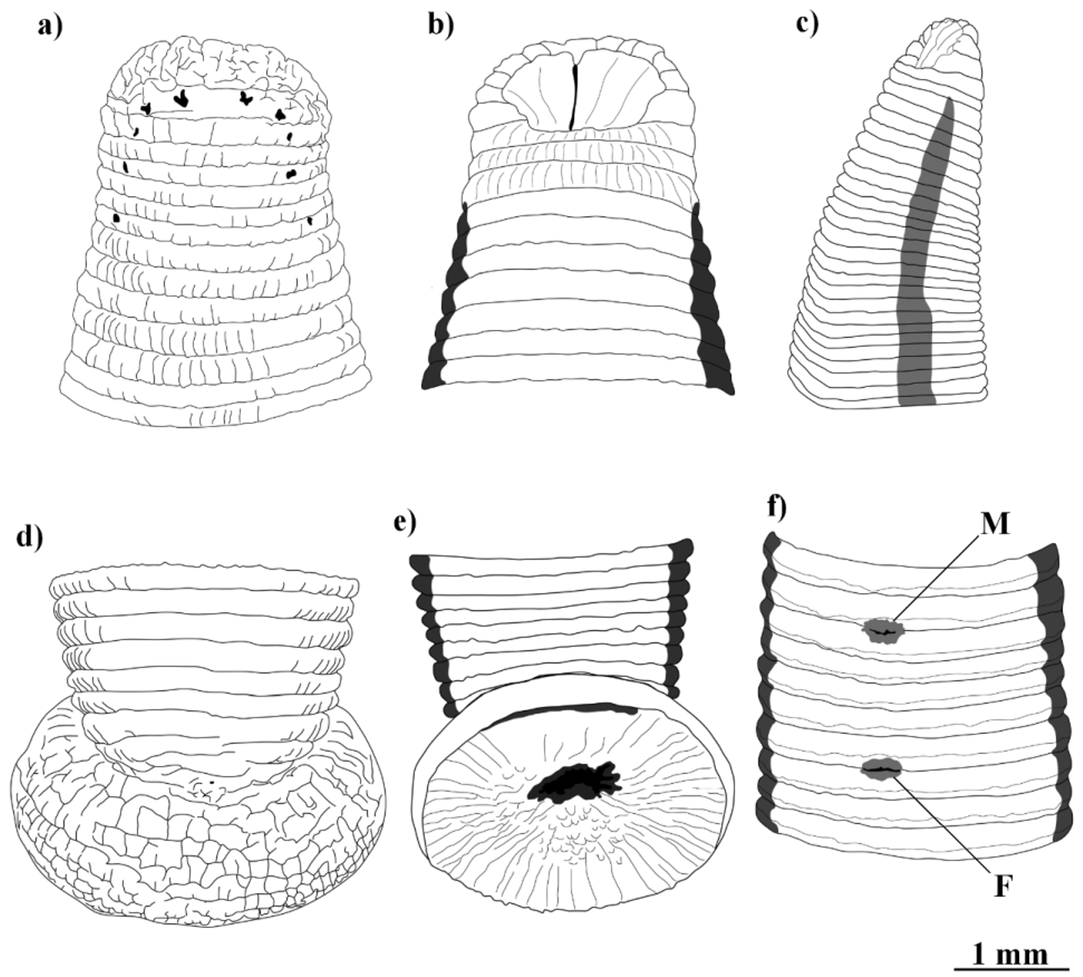
( Fig. 14 View FIGURE 14 and Plate V 1 A&B)
Material examined. ZUTC-ann 1001, 1002.
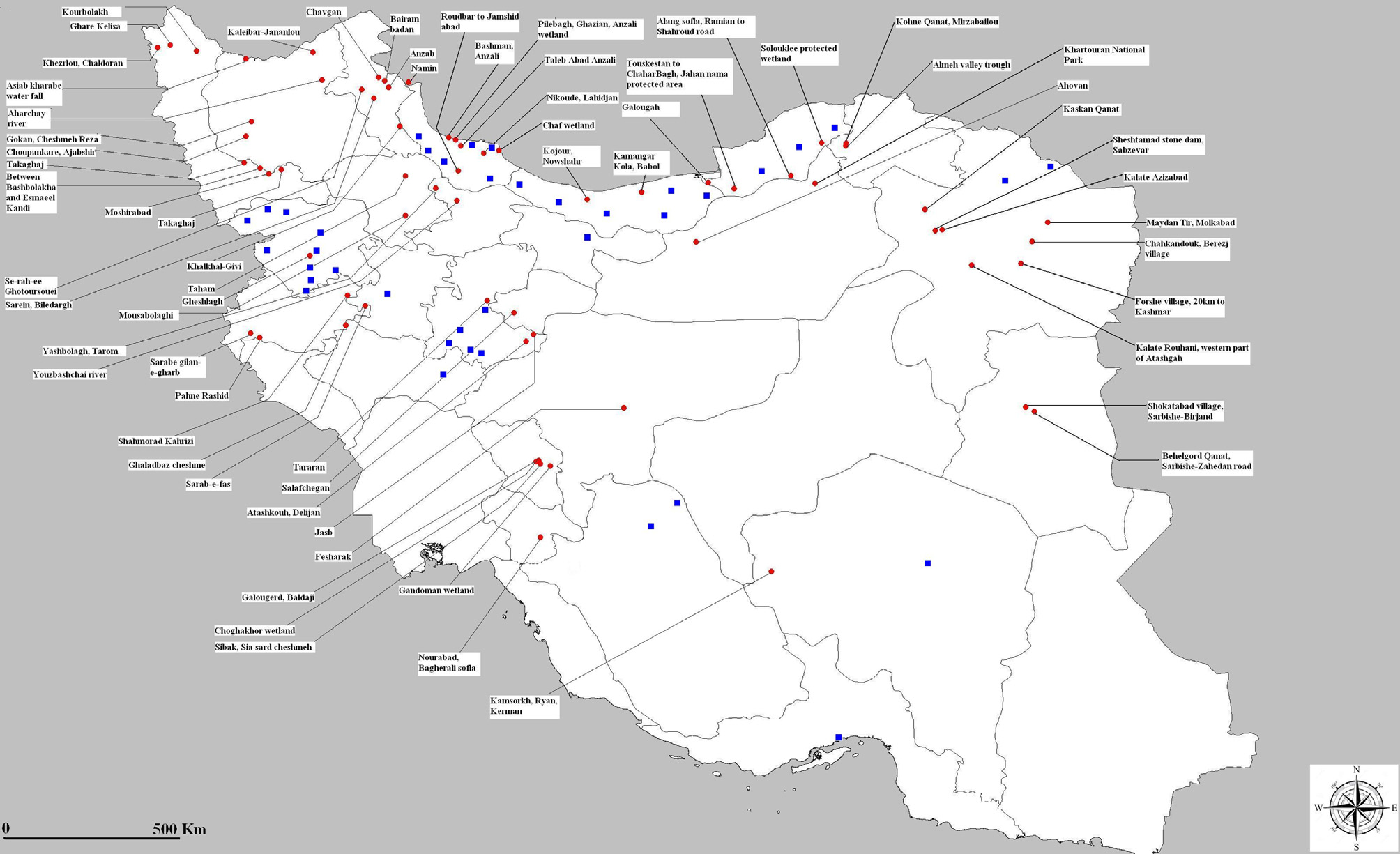
Kaskan Qanat , Khorasan Razavi, ( N 36° 15´ 38.8½, E 57° 33´ 29.3½), 1098m, ZUTC 5990 GoogleMaps . Sheshtamad stone dam, Sabzevar , Khorasan Razavi ( N 35° 53´ 51.4½, E 57° 44´ 13.8½), 1732m, ZUTC 5992 GoogleMaps . Kalate Aziz Abad , Khorasan Razavi, ( N 35° 54´ 40.8½, E 57° 51´ 26.2½), 1369m, ZUTC 5993 GoogleMaps . Maydan Tir, 2 km after Aman Abad, Molk Abad , Khorasan Razavi, ( N 36° 02´ 11.7½, E 59° 40´ 26.5½), 1152m, ZUTC 5994 GoogleMaps . Kalate Rouhani, western part of Atashgah , Khorasan Jonoubi, ( N 35° 18´ 0.5½, E 58° 22´ 01.6½), 1120m, ZUTC 5996 GoogleMaps . Kohne Qanat, Mirzabailou , Golestan National Park, (N 37° 24΄ 02.9˝, E 56° 11΄ 56.1˝), 1603m, ZUTC 6008 . Almeh valley trough, Golestan National Park, (N 37° 21΄ 14.3˝, E 56° 11΄ 53.7˝), 1358m, ZUTC 6009 . Khartouran National Park , Semnan, (N 36° 42΄ 28.25˝, E 55° 40΄ 08.27˝), 1137m, ZUTC 6010 . Tararan village, Tafresh , (N 34° 41΄ 31.38˝, E 50° 0΄ 42.48˝), 1908m, ZUTC 6039 . Bayrambadan village , Ardabil, (N 38° 28΄ 32.8˝, E 48° 14΄ 50˝), 1433m, ZUTC 6055 . Takagaj village, Miandoab , Azerbaijan Gharbi, (N 36° 56΄ 50.3˝, E 46° 27΄ 57.3˝), 1591 m, ZUTC 6068 . Kourbolagh , Bolaghi-Zia-e-din road, Azerbaijan Gharbi, (N 38° 59΄ 37˝, E 45° 00΄ 19.3˝), 1316m, ZUTC 6062 . Khezrlou, Chaldoran , Azerbaijan Gharbi, (N 39° 02΄ 48.9˝, E 44° 19΄ 56.1˝), 1906m, ZUTC 6064 ( Fig. 1 View FIGURE 1 ).
General distribution and habitats. Known from the south-western Mediterranean part of the Western Palaearctic ( Nesemann & Neubert 1999), also recorded by Bennike (1940) from western Iran. Living in troughs, channels and shallow slow running springs and streams frequently visited by herbivore herds and cattle attached to the wall of the channels or lurking in the mud.
Descriptive features and remarks. Large leeches (to 120 mm) with a body shape like a semi-flattened cylinder. Caudal sucker large and wider than the maximum body width. Genital pores separated by five annuli. Dorsally and ventrally, uni-colored grass or dark green with no stripes or patches. Laterally with yellowish orange bands clearly visible (unlike the description by Sawyer, 1986). Papillae absent.
No known copyright restrictions apply. See Agosti, D., Egloff, W., 2009. Taxonomic information exchange and copyright: the Plazi approach. BMC Research Notes 2009, 2:53 for further explanation.
|
Kingdom |
|
|
Phylum |
|
|
Class |
|
|
Order |
|
|
Family |
|
|
Genus |