
Nicrophorus interruptus Stephens, 1830
|
publication ID |
https://doi.org/10.11646/zootaxa.4441.3.10 |
|
publication LSID |
lsid:zoobank.org:pub:25DC9A68-CA02-4187-A2FB-9D80DF22F8A7 |
|
DOI |
https://doi.org/10.5281/zenodo.5965885 |
|
persistent identifier |
https://treatment.plazi.org/id/03DF87ED-F470-C059-7CF0-F80BFD0A4813 |
|
treatment provided by |
Plazi |
|
scientific name |
Nicrophorus interruptus Stephens, 1830 |
| status |
|
Nicrophorus interruptus Stephens, 1830
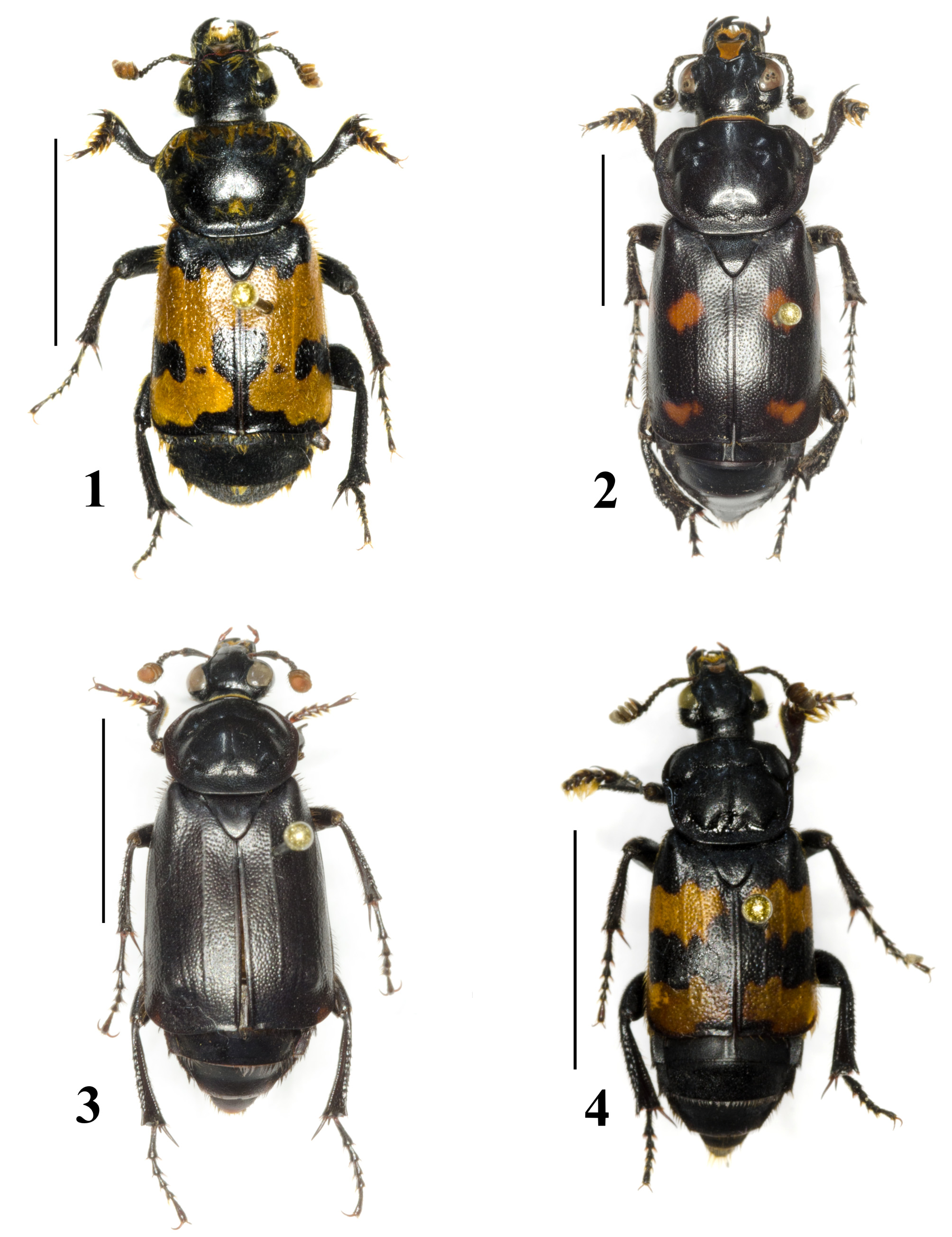
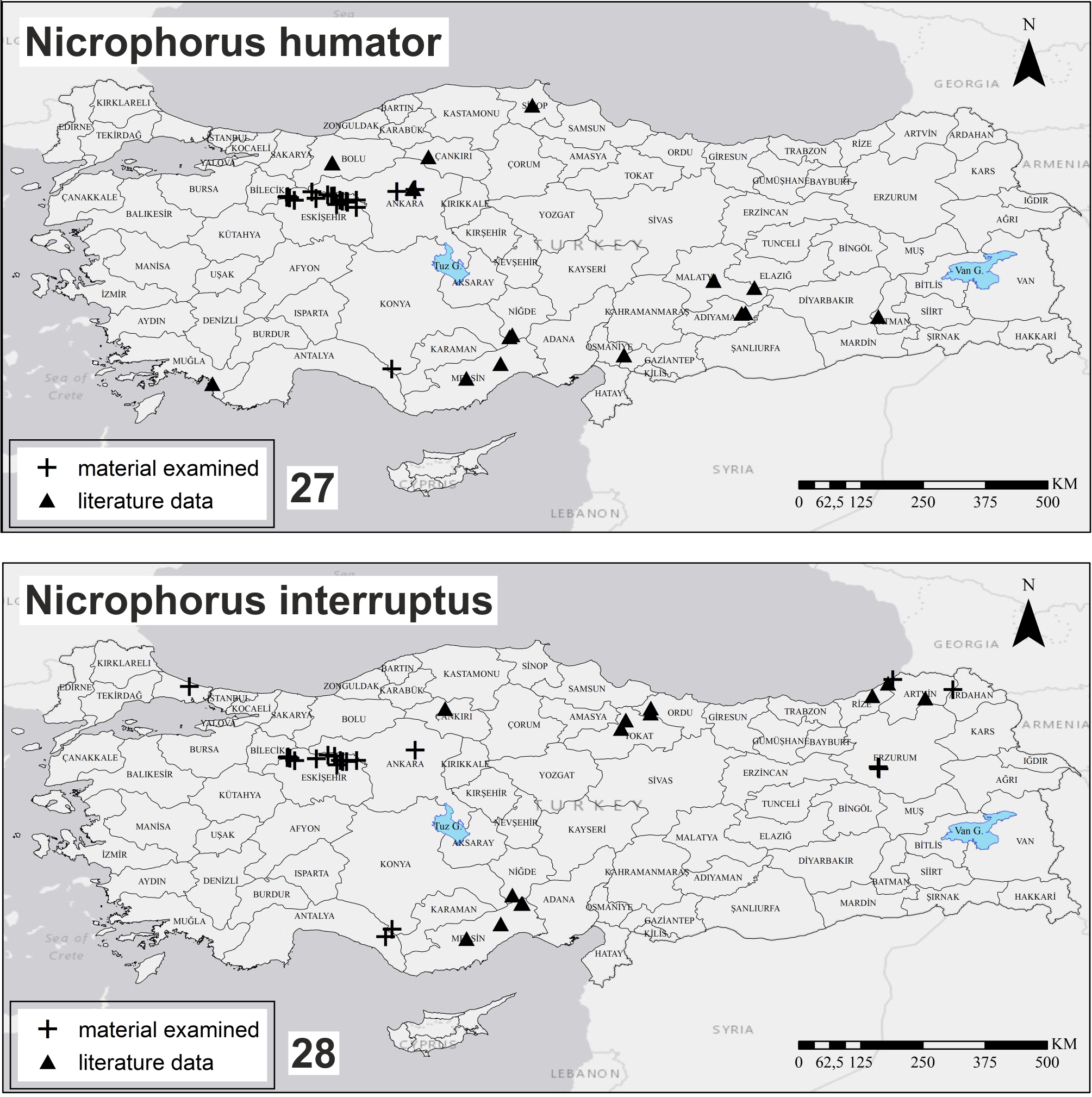
( Figs 4 View FIGURES 1–4 , 28 View FIGURES 27–28 )
Material examined. Turkey: Ankara: 2 spec., Keçiören, S of Sarıbeyler village , 40°06'32.99"N / 32°46'24.88"E, 1264 m, 22.VI.2010, Mehmet Karadağ leg. (MAZMGU) GoogleMaps ; Antalya: 1 spec., Gündoğmuş, Yeniköy village , 36°43'54.26"N / 32°14'29.98"E, 891 m, 12.VI.2008, A. Hasbenli leg. (MAZMGU) GoogleMaps ; Artvin: 1 male, 12 km E of Şavşat, Çam pass, 41°12.0'N / 042°30.6'E, 2450–2485 m, 2.–9.VII.2004, Jiří Hájek & Jan Růžička leg., steppe and pasture on N slope, baited pitfall traps (fish meat) with ethylene glycol ( JRUC) GoogleMaps ; 1 female, Hopa , ca. 41°23'N / 041°25'E, 3.VII.1993, R. Nerger leg. ( RNEC) GoogleMaps ; Erzurum: 2 males, 1 female, 15 km SW of Erzurum, Palandöken Mts., Tekederesi village env., 39°48.8'N / 041°09.0'E, 1965 m, 26.VI.–13.VII.2004, Jiří Hájek & Jan Růžička leg., steppe near spring on N slope, baited pitfall traps (fish meat) with ethylene glycol ( JRUC) GoogleMaps ; 4 males, same locality, 39°46.1'N / 041°10.3'E, 2575–2625 m, 26.VI.–13.VII.2004, Jiří Hájek & Jan Růžička leg., scree near snow field on W slope, baited pitfall traps (fish meat) with ethylene glycol ( JRUC) GoogleMaps ; 7 males, 7 females, same locality, 2230 m, 26.VI.–13.VII.2004, 39°47.6'N / 041°09.7'E, Jiří Hájek & Jan Růžička leg., steppe and meadow near spring, baited pitfall traps (fish meat) with ethylene glycol ( JRUC) GoogleMaps ; Eskişehir: 2 spec., Alpu, Başören village , 39°57'0.74"N / 30°59'20.85"E, 1044 m, 04.IX.2012, D. Çiftçi leg. (MAZMGU); 1 spec., same locality GoogleMaps , 15.XI.2012, D. Çiftçi leg. (MAZMGU); 2 spec., Mihalıçcık, Lütfiye village , 39°54'3.45"N / 31°27'45.80"E GoogleMaps , 1560 m, 14.VI.2012, D. Çiftçi leg. (MAZMGU); 1 spec., same locality GoogleMaps , 26.VI.2012, D. Çiftçi leg. (MAZMGU), 2 spec., 11.VIII.2012, D. Çiftçi leg. (MAZMGU); 2 spec., Mihalıçcık, Yeşilyurt village , 40°1'3.61"N / 31°11'55.96"E GoogleMaps , 1307 m, 14.VI.2012, D. Çiftçi leg. (MAZMGU); 2 spec., same locality GoogleMaps , 26.VI.2012, D. Çiftçi leg. (MAZMGU), 6 spec., 12.VII.2012, D. Çiftçi leg. (MAZMGU); 6 spec., Mihalıçcık, Korucu village , 39°50'24.96"N / 31°21'32.17"E GoogleMaps , 1016 m, 15.VI.2012, D. Çiftçi leg. (MAZMGU); 1 spec., Mihalıçcık, between Narlı—Sekiören villages, 39°55'11.73"N / 31°42'55.28"E GoogleMaps , 1100 m, 25.VI.2012, D. Çiftçi leg. (MAZMGU); 1 spec., Mihalıçcık, 6th km on road between Gürleyik— Yalımkaya villages, 39°59'50.80"N / 31°19'7.84"E GoogleMaps , 1076 m, 26.VI.2012, D. Çiftçi leg. (MAZMGU); 1 spec., same locality GoogleMaps , 12.VII.2012, D. Çiftçi leg. (MAZMGU); 1 spec., Mihalıçcık, between Güreş-Belen villages, 39°54'6.88"N / 31°32'9.71"E GoogleMaps , 1220 m, 10.VIII.2012, D. Çiftçi leg. (MAZMGU); 7 spec., Mihalıçcık, between Sorkun-Lütfiye villages, 39°55'17.50"N / 31°25'15.52"E GoogleMaps , 1413 m, 11.VIII.2012, D. Çiftçi leg. (MAZMGU); 47 spec., Tepebaşı, road of Avlamış-Alpagut , 39°58'15.30"N / 30°27'43.59"E GoogleMaps , 1005 m, 28.VI.2012, D. Çiftçi leg. (MAZMGU); 84 spec., same locality GoogleMaps , 13.VII.2012, D. Çiftçi leg. (MAZMGU), 25 spec., 13.VII.2012, D. Çiftçi leg. (MAZMGU); 156 spec., 12.VIII.2012, D. Çiftçi leg. (MAZMGU), 18 spec., 05.IX.2012, D. Çiftçi leg. (MAZMGU); 32 spec., 16.XI.2012, D. Çiftçi leg. (MAZMGU); 8 spec., Tepebaşı, Bozdağ village , 39°55'1.82"N / 30°35'44.01"E GoogleMaps , 1308 m, 28.VI.2012, D. Çiftçi leg. (MAZMGU); 44 spec., same locality GoogleMaps , 05.IX.2012, D. Çiftçi leg. (MAZMGU), 5 spec., 13.VII.2012, D. Çiftçi leg. (MAZMGU); 44 spec., Tepebaşı, between Tekeciler—Atalantekke villages, 39°57'42.19"N / 30°30'32.30"E GoogleMaps , 970 m, 13.VIII.2012, D. Çiftçi leg. (MAZMGU); 23 spec., same locality GoogleMaps , 05.IX.2012, D. Çiftçi leg. (MAZMGU), 1 spec., 16.XI.2012, D. Çiftçi leg. (MAZMGU); İstanbul: Arnavutköy, NE of Tayakadın village , 41°15'29.19"N / 28°41'30.26"E, 130ist m, 17.V.2014, A. Hasbenli leg. (MAZMGU) GoogleMaps ; Konya: 7 spec., Hadim, Beyreli village, Gevne Valley , 36°52'3.03"N / 32°21'29.66"E, 1655 m, 11.VI.2008, A. Hasbenli leg. (MAZMGU). GoogleMaps
Distribution in Turkey. Tokat, Ordu, Artvin ( Háva et al. 1998); Adana, Niğde, Mersin ( Açar 2008); Çankırı, Tokat, Ordu, Rize, Artvin ( Sikes & Venables 2013a, b).
Remarks. Widely distributed Palaearctic species, known from most of Europe to Eastern Siberia and the west of China (Růžička 2015). In central Europe, abundant both in forested habitats and in open habitats such as fields and grasslands ( Růžička 1994; Jakubec & Růžička 2012, 2015). In Turkey, distributed within Eastern Anatolia, southeastern Anatolia and the Aegean Regions ( Fig. 28 View FIGURES 27–28 ). Here we provide the first records from Ankara, Antalya, Erzurum, Eskişehir, Konya and İstanbul Provinces.
No known copyright restrictions apply. See Agosti, D., Egloff, W., 2009. Taxonomic information exchange and copyright: the Plazi approach. BMC Research Notes 2009, 2:53 for further explanation.
|
Kingdom |
|
|
Phylum |
|
|
Class |
|
|
Order |
|
|
Family |
|
|
SubFamily |
Nicrophorinae |
|
Genus |