
Obtusella macilenta ( Monterosato, 1880 )
|
publication ID |
https://doi.org/ 10.11646/zootaxa.5196.1.1 |
|
publication LSID |
lsid:zoobank.org:pub:1B12892E-D68F-4BFE-8E9A-7F19E220E73D |
|
DOI |
https://doi.org/10.5281/zenodo.7231961 |
|
persistent identifier |
https://treatment.plazi.org/id/03D37947-4870-FFEF-A0B1-F8664571033F |
|
treatment provided by |
Plazi |
|
scientific name |
Obtusella macilenta ( Monterosato, 1880 ) |
| status |
|
Obtusella macilenta ( Monterosato, 1880) View in CoL
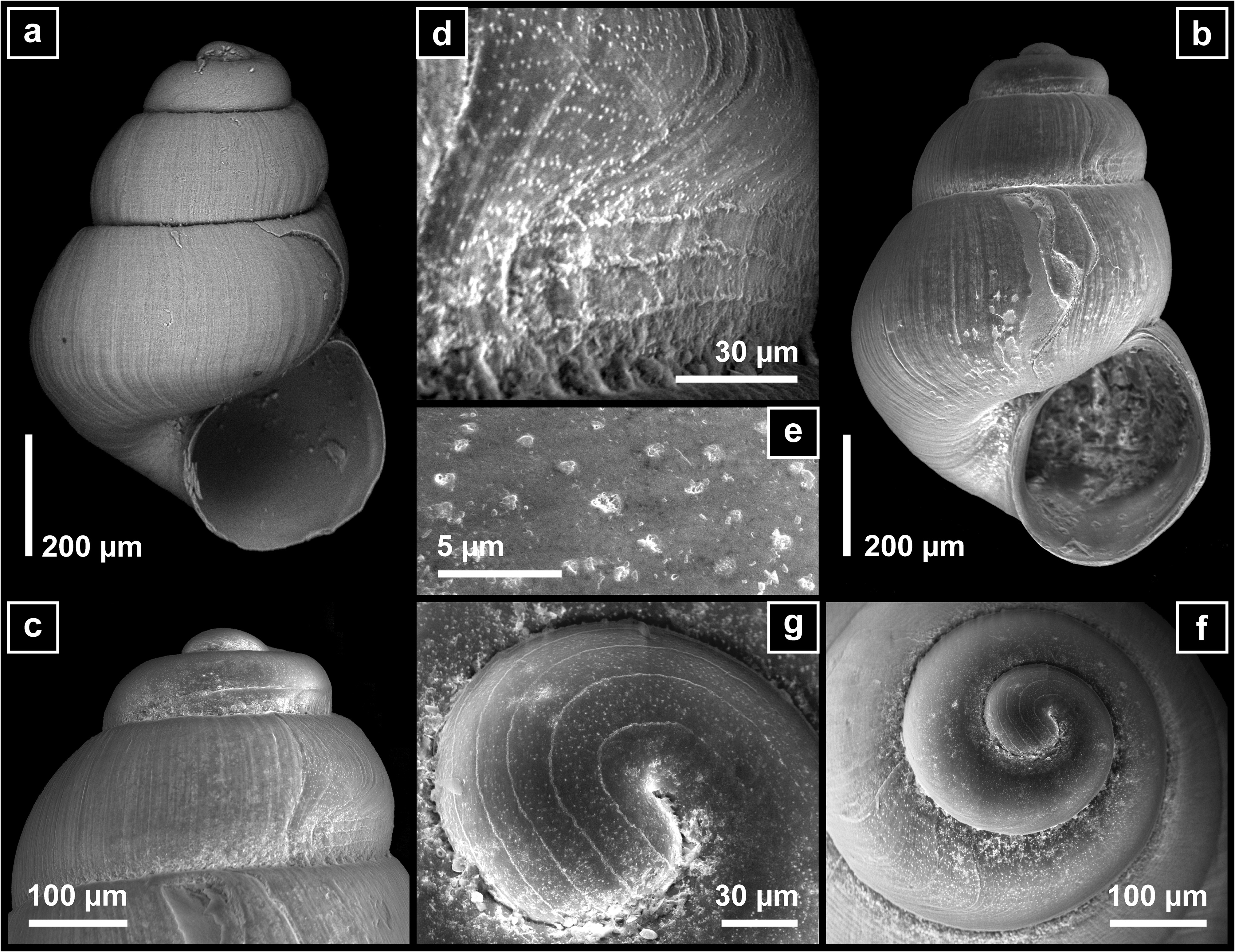
( Fig. 19 View FIGURE 19 )
Material examined. (more than 2000 shells, most of them with soft parts, in 25 samples): SPAIN • 1 sPc; 43° 57.030′N, 008° 54.795′W to 43° 57.248′N, 008° 54.133′W; 1191– 1132 m; 08–15 SeP. 2002; DIVA-Artabria I AT-1000 GoogleMaps • 250 spc + 100 sh; 43° 35.451′N, 008° 34.432′W to 43° 34.810′N, 008° 35.407′W; 153– 151 m; 08–15 SeP. 2002; DIVA-Artabria I EBS-150 GoogleMaps • 10 sPc + 7 sh; 43° 40.192′N, 008° 43.760′W to 43° 40.943′N, 008° 42.366′W; 207–212 m; 08–15 Sep. 2002; DIVA-Artabria I EBS-200 GoogleMaps • 4 sPc + 2 sh; 43° 41.113′N, 008° 44.297′W to 43° 41.905′N, 008° 43.078′W; 256–258 m; 08–15 Sep. 2002; DIVA-Artabria I EBS-250 GoogleMaps • 5 sPc + 1 sh; 43° 41.689′N, 008° 45.195′W to 43° 42.556′N, 008° 44.226′W; 298–303 m; 08–15 SeP. 2002; DIVA-Artabria I EBS-300 GoogleMaps • 2 sPc; 43° 42.348′N, 008° 45.889′W to 43° 43.269′N, 008° 45.289′W; 344–354 m; 10–20 SeP. 2003; DIVA-Artabria I EBS-350 GoogleMaps • 1 sPc; 43° 45.892′N, 008° 44.301′W to 43° 46.966′N, 008° 43.766′W; 390– 381 m; 08–15 SeP. 2002; DIVA-Artabria I EBS-400 GoogleMaps •> 300 spc + 100 sh; 43° 26.703′N, 008° 30.669′W to 43° 27.452′N, 008° 29.612′W; 103– 102 m; 10–20 SeP. 2003; DIVA-Artabria I EBS-100 GoogleMaps •> 200 sPc + 100 sh; 43° 35.451′N, 008° 34.432′W to 43° 34.810′N, 008° 35.407′W; 153– 151 m; 08–15 Sep. 2002; DIVA-Artabria I EBS-150 GoogleMaps • 15 sPc + 2 sh; 43° 40.250′N, 008° 43.755′W to 43° 40.760′N, 008° 42.120′W; 207– 197 m; 10–20 Sep. 2003; DIVA-Artabria I EBS-200 GoogleMaps • 9 sPc + 4 sh; 43° 41.590′N, 008° 45.328′W to 43° 42.396′N, 008° 44.286′W; 301– 301 m; 10–20 SeP. 2003; DIVA-Artabria I EBS-300 GoogleMaps • 2 sPc; 43° 42.348′N, 008° 45.889′W to 43° 43.269′N, 008° 45.289′W; 344–354 m; 10–20 SeP. 2003; DIVA-Artabria I EBS-350 GoogleMaps • 3 sh; 43° 48.587′N, 008° 51.402′W to 43° 49.545′N, 008° 51.197′W; 610– 598 m; 10–20 SeP. 2003; DIVA-Artabria I EBS-600 GoogleMaps • 15 sh; 43° 29.412′N, 008° 28.362′W to 43° 29.779′N, 008° 28.240′W; 110–111 m; 17–28 SeP. 2004; VERTIDOS GA-AT-110 • 4 sPc; 43° 32.026′N, 008° 37.520′W to 43° 32.806′N, 008° 35.993′W; 150–151 m; 17–28 SeP. 2004; VERTIDOS GA-AT-150 GoogleMaps • 25 sPc + 10 sh; 43° 31.970′N, 008° 37.670′W to 43° 32.697′N, 008° 3.171′W; 151– 151 m; 17–28 SeP. 2004; VERTIDOS GA-EBS-150 GoogleMaps • 5 sPc + 4 sh; 43° 36.222′N, 008° 52.845′W to 43° 36.797′N, 008° 52.112′W; 201– 201 m; 17–28 Sep. 2004; VERTIDOS GA-EBS-200 GoogleMaps • 2 spc; 43° 35.611′N, 008° 58.536′W to 43° 36.104′N, 008° 57.284′W; 384– 345 m; 17–28 Sep. 2004; VERTIDOS GA-EBS-400 GoogleMaps •> 100 sPc; 42° 30.391′N, 009° 19.517′W to 42° 29.428′N, 009° 17.924′W; 147–148 m; 17–28 SeP. 2004; VERTIDOS AG-EBS-150 • 80 sPc; 42° 31.176′N, 009° 23.380′W to 42° 32.132′N, 009° 24.151′W; 242–248 m; 17–28 SeP. 2004; VERTIDOS AG-EBS-250 •>600 sPc; 42° 50.507′N, 009° 25.773′W to 42° 48.810′N, 009° 25.198′W; 151– 148 m; 17–28 SeP. 2004; VERTIDOS CA-EBS-150 •>100 spc; 42° 15.780′N, 009° 10.500′W to 42° 17.100′N, 009° 10.630′W; 149–150 m; 17–28 SeP. 2004; VERTIDOS CH-EBS-150 • 1 sh; Polygon delimited by Points 44° 10.000′ N, 009° 00.000′ W /44° 10.000′ N, 008° 35.000′ W/44° 00.000′ N; 009° 00.000′ W/44° 07.000′ N; 008° 35.000′ W; 480–600 m; SARRIDAL (2006–2007) SARRI-2 • 1 sh; 43° 31.727′N, 008° 52.374′W to 43° 32.678′N, 008° 52.687′W; 173–179 m; 15–24 Jul. 2008; A SELVA DRN-23 GoogleMaps • 53 spc; 43° 31.687′N, 008° 52.188′W to 43° 33.149′N, 008° 53.142′W; 171–182 m; 15–24 Jul. 2008; A SELVA EBS-23 GoogleMaps • 4 spc; 43° 48.252′N, 008° 51.427′W to 43° 49.707′N, 008° 51.164′W; 575–584 m; 15-24 Jul. 2008; A SELVA EBS-30-1 GoogleMaps .
Remarks. Obtusella macilenta is known from the continental shelf and slope from the southern part of the Biscay Bay to off Morocco and the Mediterranean ( Gofas & Oliver 2011).
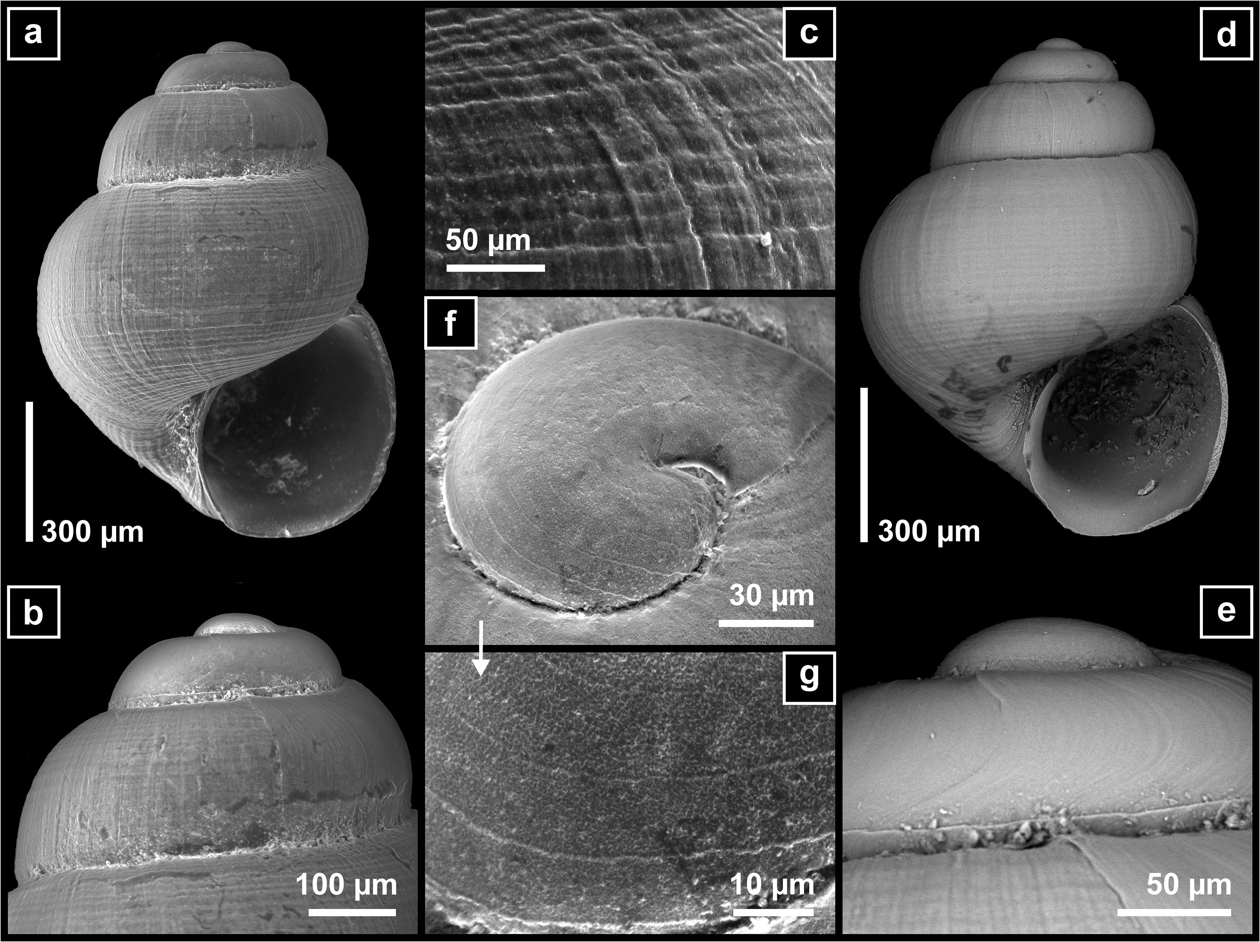
It was the most abundant species in studied samples, along with A. testae , predominantly between 100 and 250 m on muddy sand bottoms, although one shell with soft parts was found in a sample collected at 1132 m in depth. It is even smaller than the previous species; the shells studied barely reach 1 mm and are less globose with weakest spiral sculpture ( Figs. 19a–b View FIGURE 19 ). Sinuous protoconch/teleoconch transition ( Figs. 18c–e View FIGURE 18 ) and embryonic shell with up to four delicate spires ( Figs. 18f–g View FIGURE 18 ).
No known copyright restrictions apply. See Agosti, D., Egloff, W., 2009. Taxonomic information exchange and copyright: the Plazi approach. BMC Research Notes 2009, 2:53 for further explanation.
|
Kingdom |
|
|
Phylum |
|
|
Class |
|
|
SubClass |
Caenogastropoda |
|
Order |
|
|
Family |
|
|
Genus |