
Alvania testae (Aradas & Maggiore, 1844)
|
publication ID |
https://doi.org/ 10.11646/zootaxa.5196.1.1 |
|
publication LSID |
lsid:zoobank.org:pub:1B12892E-D68F-4BFE-8E9A-7F19E220E73D |
|
DOI |
https://doi.org/10.5281/zenodo.7231951 |
|
persistent identifier |
https://treatment.plazi.org/id/03D37947-4864-FFFC-A0B1-F9D345FB0126 |
|
treatment provided by |
Plazi |
|
scientific name |
Alvania testae (Aradas & Maggiore, 1844) |
| status |
|
Alvania testae (Aradas & Maggiore, 1844) View in CoL
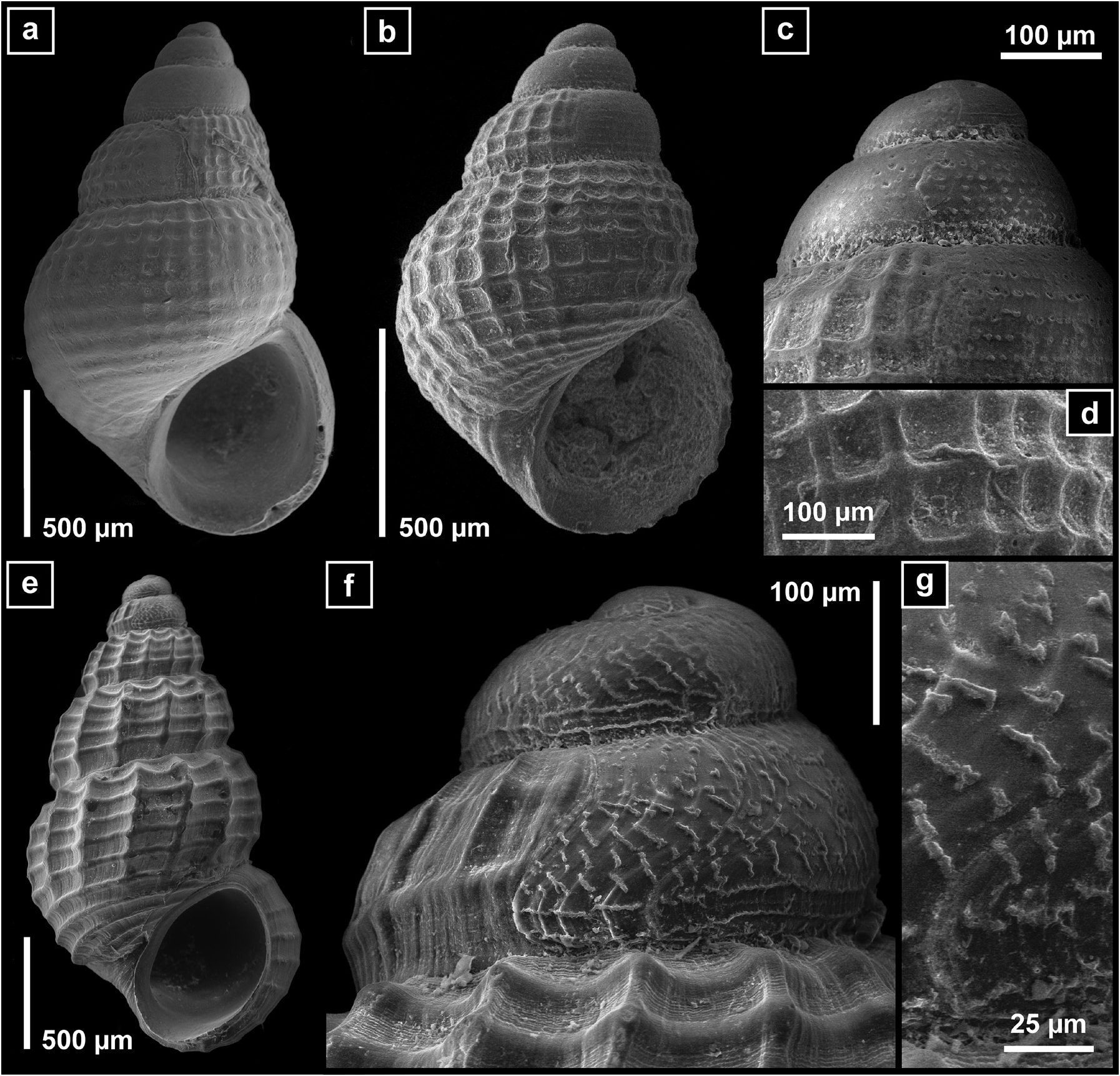
( Figs. 5 e–g View FIGURE 5 )
Material examined. (nearly 2000 shells, most of them with soft parts, in 33 samples): SPAIN • 1 s; 43° 40.165′N, 008° 43.697′W to 43° 40.513′N, 008° 43.159′W; 204–209 m; 08–15 SeP. 2002; DIVA-Artabria I DRN-200 GoogleMaps • >80 sPc; 43° 35.451′N, 008° 34.432′W to 43° 34.810′N, 008° 35.407′W; 153– 151 m; 08–15 SeP. 2002; DIVA-Artabria I EBS-150 GoogleMaps • 40 spc; 43° 40.192′N, 008° 43.760′W to 43° 40.943′N, 008° 42.366′W; 207–212 m; 08–15 SeP. 2002; DIVA-Artabria I EBS-200 GoogleMaps • 10 sPc; 43° 41.689′N, 008° 45.195′W to 43° 42.556′N, 008° 44.226′W; 298–303 m; 08–15 SeP. 2002; DIVA-Artabria I EBS-300 GoogleMaps • 1 spc (juv); 43° 53.575′N, 008° 56.868′W to 43° 54.015′N, 008° 56.959′W; 965–974 m; 10–20 SeP. 2003; DIVA-Artabria I DRN-1000 GoogleMaps •> 80 sPc; 43° 34.116′N, 008° 36.535′W to 43° 34.689′N, 008° 35.589′W; 149– 148 m; 10–20 Sep. 2003; DIVA-Artabria I AT-150 GoogleMaps •> 200 spc; 43° 34.127′N, 008° 36.562′W to 43° 34.820′N, 008° 35.585′W; 152– 149 m; 10–20 Sep. 2003; DIVA-Artabria I EBS-150 GoogleMaps •> 50 spc; 43° 40.250′N, 008° 43.755′W to 43° 40.760′N, 008° 42.120′W; 207– 197 m; 10–20 Sep. 2003; DIVA-Artabria I EBS-200 GoogleMaps •> 300 spc; 43° 41.590′N, 008° 45.328′W to 43° 42.396′N, 008° 44.286′W; 301– 301 m; 10–20 SeP. 2003; DIVA-Artabria I EBS-300 GoogleMaps • 1 sh; 43° 42.348′N, 008° 45.889′W to 43° 43.269′N, 008° 45.289′W; 344–354 m; 10–20 SeP. 2003; DIVA-Artabria I EBS-350 GoogleMaps • 30 spc + 200 sh; 43° 29.412′N, 008° 28.362′W to 43° 29.779′N, 008° 28.240′W; 110–111 m; 17–28 SeP. 2004; VERTIDOS GA-AT-110 • 50 sPc; 43° 32.026′N, 008° 37.520′W to 43° 32.806′N, 008° 35.993′W; 150–151 m; 17–28 SeP. 2004; VERTIDOS GA-AT-150 • 1 spc (juv); 43° 38.105′N, 009° 02.006′W to 43° 37.738′N, 009° 00.905′W; 836– 826 m; 17–28 SeP. 2004; VERTIDOS GA-AT-800 • 30 sPc; 42° 29.455′N, 009° 17.472′W to 42° 31.292′N, 009° 19.660′W; 149– 147 m; 17–28 SeP. 2004; VERTIDOS AG-AT-150 •>40 sPc; 42° 47.353′N, 009° 25.161′W to 42° 44.866′N, 009° 25.913′W; 147– 146 m; 17–28 SeP. 2004; VERTIDOS CA-AT-150 • 30 spc; 43° 31.970′N, 008° 37.670′W to 43° 32.697′N, 008° 3.171′W; 151– 151 m; 17–28 SeP. 2004; VERTIDOS GA-EBS-150 GoogleMaps • 25 spc; 43° 36.222′N, 008° 52.845′W to 43° 36.797′N, 008° 52.112′W; 201– 201 m; 17–28 Sep. 2004; VERTIDOS GA-EBS-200 GoogleMaps • >800 spc; 42° 30.391′N, 009° 19.517′W to 42° 29.428′N, 009° 17.924′W; 147–148 m; 17–28 Sep. 2004; VERTIDOS AG-EBS-150 •>50 spc; 42° 31.176′N, 009° 23.380′W to 42° 32.132′N, 009° 24.151′W; 242–248 m; 17–28 Sep. 2004; VERTIDOS AG-EBS-250 •>200 sPc; 42° 50.507′N, 009° 25.773′W to 42° 48.810′N, 009° 25.198′W; 151– 148 m; 17–28 SeP. 2004; VERTIDOS CA-EBS-150 • 30 sPc; 42° 15.780′N, 009° 10.500′W to 42° 17.100′N, 009° 10.630′W; 149–150 m; 17–28 SeP. 2004; VERTIDOS CH-EBS-150 • 8 sh; 43° 29.13′N, 008° 43.233′W to 43° 29.596′N, 008° 42.838′W; 149–151 m; 15–24 Jul. 2008; A SELVA DRN-22 GoogleMaps • 14 spc; 43° 31.727′N, 008° 52.374′W to 43° 32.678′N, 008° 52.687′W; 173–179 m; 15–24 Jul. 2008; A SELVA DRN-23 GoogleMaps • 12 sPc; 44° 06.496′N, 008° 23.522′W to 44° 07.16′N, 008° 23.201′W; 337– 324 m; 15–24 Jul. 2008; A SELVA AT-13 GoogleMaps • 1 spc + 1 sh; 44° 08.516′N, 008° 40.788′W to 44° 09.688′N, 008° 39.721′W; 436– 428 m; 15–24 Jul. 2008; A SELVA EBS-11 GoogleMaps • 14 sPc; 44° 05.687′N, 008° 24.558′W to 44° 07.253′N, 008° 24.302′W; 337– 330 m; 15–24 Jul. 2008; A SELVA EBS-13 GoogleMaps • 15 sPc; 44° 00.806′N, 008° 33.098′W to 44° 01.967′N, 008° 32.57′W; 346– 344 m; 15–24 Jul. 2008;A SELVA EBS-14 GoogleMaps • 17 sPc + 10 sh; 43° 58.84′N, 008° 15.625′W to 43° 59.621′N, 008° 14.285′W; 233–237 m; 15–24 Jul. 2008; A SELVA EBS-20 GoogleMaps •> 50 sPc; 43° 31.687′N, 008° 52.188′W to 43° 33.149′N, 008° 53.142′W; 171–182 m; 15–24 Jul. 2008; A SELVA EBS-23 GoogleMaps • 5 sPc; 43° 48.252′N, 008° 51.427′W to 43° 49.707′N, 008° 51.164′W; 575–584 m; 15–24 Jul. 2008; A SELVA EBS-30-1 GoogleMaps • 4 sPc + 3 sh; 43° 33.20′N, 008° 58.78′W to 43° 34.57′N, 008° 56.90′W; 230–236 m; 15–30 SeP. 2008; DIVA-Artabria II EBS-01 GoogleMaps • 1 sh; 43° 34.86′N, 009° 21.95′W to 43° 36.44′N, 009° 20.71′W; 1010–1112 m; 15–30 SeP. 2008; DIVA-Artabria II EBS-04 GoogleMaps • 2 sPc; 43° 19.92′N, 009° 38.13′W to 43° 21.25′N, 009° 37.11′W; 1267–1286 m; 15–30 SeP. 2008; DIVA-Artabria II EBS-15 GoogleMaps • 1 sh; 42° 31.58′N, 009° 40.14′W to 42° 33.87′N, 009° 38.75′W; 2030– 1886 m; 15–30 SeP. 2008; DIVA-Artabria II EBS-30 GoogleMaps .
Remarks. Very common species that extends from Norway to off western Morocco and throughout the Mediterranean, in a wide bathymetric range 30–1000 m, occasionally deeper ( Oliverio et al. 1992; Bouchet & Warén 1993; Warén 1996; Cachia et al. 1996; Giribet & Peñas 1997; Gofas & Oliver 2011; Negri & Corselli 2016; Bitlis & Öztürk 2017). The shell is characterized by the opisthocline orientation of the peristome ( Fig. 5e View FIGURE 5 ). Protoconch sculptured by an irregular network ( Figs. 5f–g View FIGURE 5 ).
It was the most abundant species in studied the samples along with Obtusella macilenta , predominantly between 100 and 400 m in muddy sand bottoms. Its putative planktrotrophic larval development (deduced from its protoconch) enables a large dispersal capacity.
No known copyright restrictions apply. See Agosti, D., Egloff, W., 2009. Taxonomic information exchange and copyright: the Plazi approach. BMC Research Notes 2009, 2:53 for further explanation.
|
Kingdom |
|
|
Phylum |
|
|
Class |
|
|
Order |
|
|
Family |
|
|
Genus |