
Polygala bringelii J.F.B.Pastore & Antar, 2021
|
publication ID |
https://doi.org/ 10.5852/ejt.2021.762.1459 |
|
DOI |
https://doi.org/10.5281/zenodo.5211763 |
|
persistent identifier |
https://treatment.plazi.org/id/03D2878D-C401-605A-FE71-CDC19B4EFDC6 |
|
treatment provided by |
Felipe |
|
scientific name |
Polygala bringelii J.F.B.Pastore & Antar |
| status |
sp. nov. |
Polygala bringelii J.F.B.Pastore & Antar View in CoL sp. nov.
urn:lsid:ipni.org:names:77219129-1
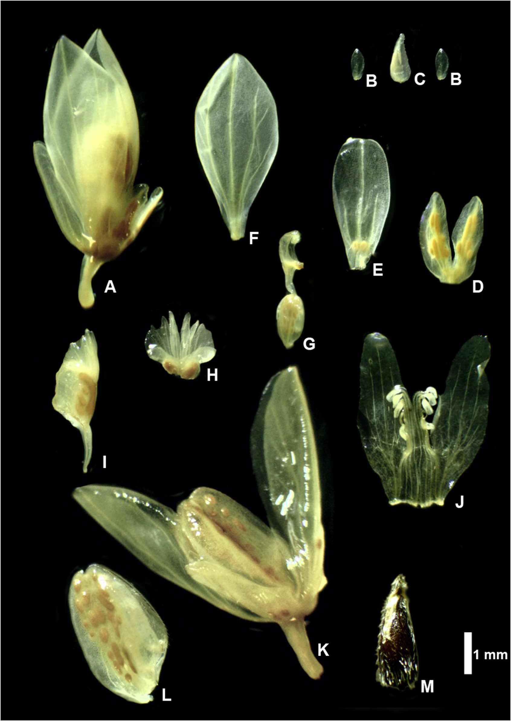
Figs 1–3 View Fig View Fig View Fig
Diagnosis
Polygala bringelii sp. nov. is similar to P. trichosperma Jacq. but differs from it by the obclavate seeds without a ring of trichomes at the base, keel with a crest shorter than the cuculus, and internal sepals (wings) longer than the capsule (vs conical seeds with a ring of trichomes at the base, keel with the crest and cuculus almost the same length and internal sepals shorter than or subequal the length of capsules in P. trichosperma ).
Etymology
The specific epithet honors Dr João Bernardo de Azevedo Bringel Junior, a prominent Brazilian synanterologist and connoisseur of the Cerrado flora. During his career at the University of Brasília and the CENARGEN he has made numerous collecting expeditions in that domain and collected one of the paratypes of this new species.
Material examined
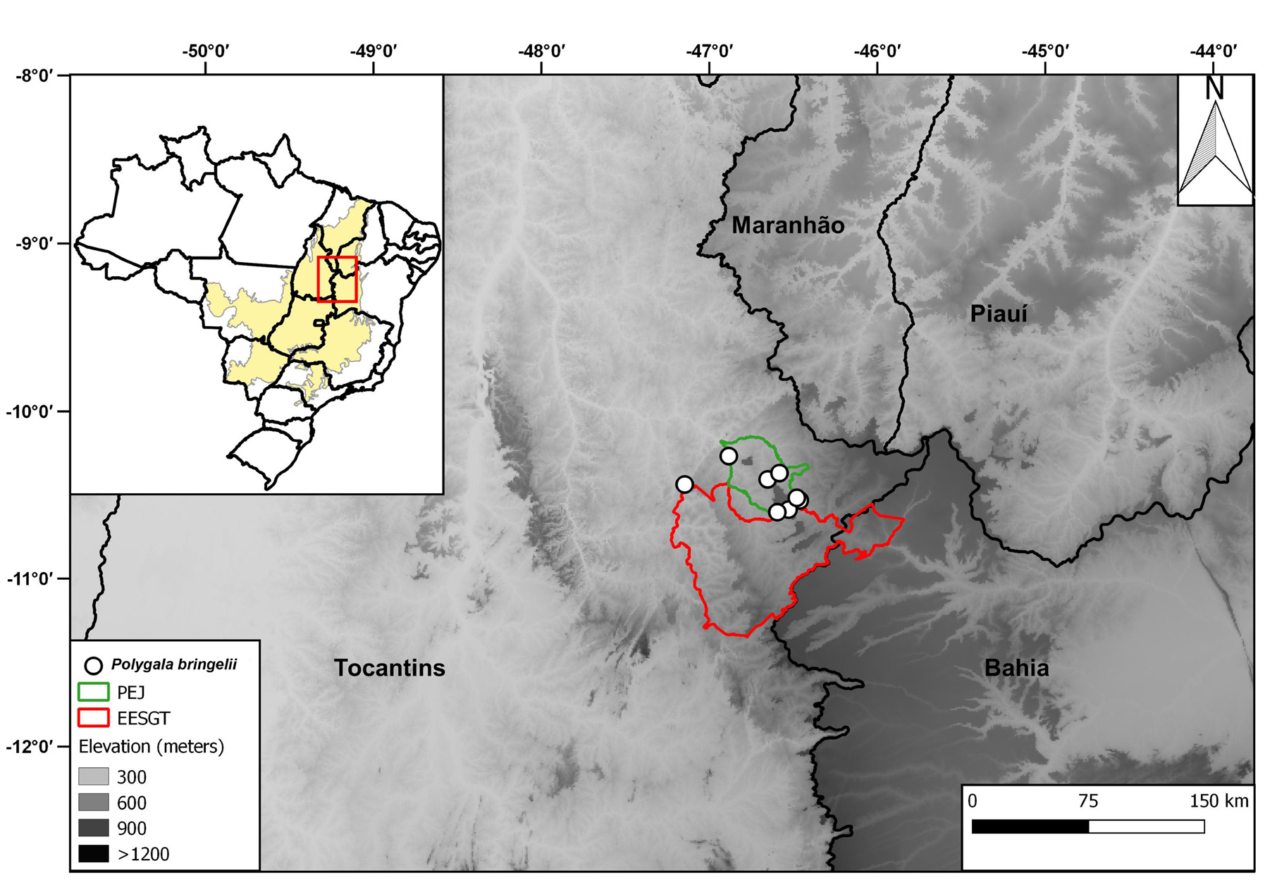
Type BRAZIL – Tocantins • Mateiros, Próximo a Fazenda Lua Cheia, acessado pela antiga estrada São Felix Mateiros; 10°32′02.8″ S, 46°27′43.4″ W; 543 m alt.; 24 Jan. 2014; " G.M. Antar et L.F. Nascimento 380; holotype: CTBS[n. 3715], isotype: SPF [ SPF00220131 View Materials ]" GoogleMaps .
Paratypes BRAZIL – Tocantins • Mateiros, Parque Estadual do Jalapão, estrada de terra Mateiros-Ponte Alta do Tocantins, a 15 km de Mateiros; 10º35′19″ S, 46º31′42″ W; 14 Jun. 2002; T.B. Cavalcanti et al. 2747; CEN[ CEN00053241 ], CTBS[n. 341] GoogleMaps • Parque Estadual do Jalapão, Mumbuca, brejo do Antônio, local de extração de Capim Dourado; 10º22′17″ S, 46º34′58″ W; 17 Jun. 2002; T.B. Cavalcanti et al. 2890; CEN[ CEN00053271 ], CTBS[n. 335] GoogleMaps • Área de implementação do centro de recepção de visitantes do PEJ ; 10º34′35.6″ S, 46º30′25.9″ W; 24 May 2003; E.R. Santos et al. 939; HTO GoogleMaps • Parque Estadual do Jalapão , brejo dos veados, próximo a pequeno morro; 8 Aug. 2006; M. Watanabe, P.T. Sano and M.L.O. Trovó 22; CTBS[n. 3724], SPF [ SPF00222919 View Materials ] • Jalapão, estrada para o local popularmente conhecido como Varjão; 10º24′32.3″ S, 46º39′11.9″ W; 430 m alt.; 6 Aug. 2013; G.M. Antar and P.T. Sano 233; SPF [ SPF00220129 View Materials ] GoogleMaps • Parque Estadual do Jalapão, Próximo a Fazenda Lua Cheia, acessado pela antiga estrada São Felix Mateiros; 10°32′02.8″ S, 46°27′43.4″ W; 543 m alt.; 20 Jan. 2014; G.M. Antar and L.F. Nascimento 346; SPF [ SPF00220130 View Materials ] GoogleMaps • Parque Estadual do Jalapão , margens da TO-255; 10º36′15.1″ S, 46º35′43.3″ W; 2 Jul. 2014; J.A. Lombardi et al. 10344; HRCB[n. 63162], UPCB GoogleMaps • Ponte Alta do Tocantins, Cachoeira da Velha ; 29 May 2008; J.M. Silva et al. 6869; CTBS[n. 2533], MBM [n. 343560], SPF [ SPF00230507 View Materials ] • estrada de terra de Ponte Alta do Tocantins a Mateiros, 58.6 km de Ponte Alta; 10º26′21″ S, 47º08′49″ W; 27 Mar. 2011; J.B. Bringel and H.J.C. Moreira 729; UB GoogleMaps .
Description
Erect herbs 20–40 cm tall; roots rigid; single to multiple stems arising from the base, branching from the base to the apex, cylindrical, green, without yellowish glands, densely puberulous, trichomes short-clavate. Leaves all alternate, subsessile, chartaceous, laminas (0.6–)0.8–1 × 0.08–0.1 cm, linear, apex acute, margins revolute, base acute, densely covered by small glandular trichomes on both sides. Racemes congested to shortly elongated 1.2–1.9 × 0.8–1 cm, up to 3.3 cm long after capsules have fallen; bracts 1.2 × 0.5 mm, lanceolate, apex acute, not ciliate, without yellowish glands, deciduous before anthesis, ca 2 times as long as the bracteoles; bracteoles elliptic, not ciliate; pedicel 1.5 mm long, glabrous. Flowers yellow, cream or whitish, 5.4–5.5 mm long (without pedicel); outer sepals not ciliate, with yellow glands; lower outer sepals 1.5 × 0.6 mm, elliptic to ovate, apex obtuse; upper outer sepals 1.4–1.5 × 0.6–0.7 mm, elliptic, apex rounded or slightly retuse; inner sepals (wings) 4.5 × 2.2 mm, elliptic, apex acute, margins not ciliate, longer than the mature fruits, without yellow glands; lateral petals 4.1 × 1 mm; keel ca 3.5 mm long, cristate, with yellow glands around the dorsal central vein, deciduous on mature fruits; crest 4–6-lobed; central lobes often bi-lobed to apex, style 1.5 mm long, erect, terminated by an oblique cymbiform pre-stigmatic cavity, posterior extremity with a conspicuously crested appendage with abundant trichomes and an anterior globose stigma. Capsules 3.5 × 1.7 mm, subovate, bearing a double line of orange glands close to the central nervure, style deciduous in fruit; seeds ca 2.5 × 1–1.1 mm, obclavate, pubescent, trichomes 0.1–0.2 mm long, without a ring of trichomes at the base of the seed, with two caruncular appendages 1.5 × 0.2–0.3 mm reaching approximately ½ of the seed length.
Distribution, habitat, and phenology
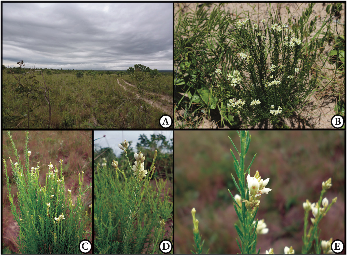
Polygala bringelii sp. nov. is endemic to the Jalapão region, Tocantins State, occurring in open natural grasslands with scattered shrubs (campo sujo and campo cerrado), occasionally near rocky outcrops, on sandy dry soils at altitudes of 350 to 550 meters in the municipalities of Mateiros and Ponte Alta do Tocantins ( Fig. 2 View Fig ). Found fertile in January and from May to August.
Preliminary conservation status
The estimated Area of Occupancy, with just 36 km ², is low; the estimated Extent of Occurrence is 1469.542 km ². The species is currently known from ten collections, with most located inside the protected area of the Parque Estadual do Jalapão. Nominally protected, these areas are still subjected to uncontrolled anthropic fires, though recently diminished in number due to a new fire management program (Schmidt e t al. 2018). Nearby areas, mostly in western Bahia State, have already been converted to agricultural use ( Borges & Antar 2016), which is expanding towards the Jalapão with governmental incentives ( Antar et al. 2018; Barbosa-Silva & Antar 2020). Although still regarded as data deficient, due to the precarious state of conservation of its suitable habitats, the species should be assessed as Endangered EN B1ab(i,ii,iii)+2ab(i,ii,iii) (IUCN 2012).
Notes
Morphologically, Polygala bringelii sp. nov. is most closely related to P. trichosperma , with both species sharing the oblong-elliptic capsules with yellow glands along the mid-vein and linear leaves. However, P. bringelii sp. nov. differs from P. trichorperma in the characters discussed in the diagnosis. Also, this new species is seemingly similar to Polygala tocantinensis sp. nov. (the other new species here described), both of them share similar sepals and yellowish flowers, differing mainly by the seed indument, with a ring of long trichomes at the seed base (vs seed without a ring of trichomes at the base in P. bringelii sp. nov.) and the keel crest in P. tocantinensis sp. nov. is much more developed (ca twice the size) than in P. bringelii sp. nov.
| MBM |
Myanmar, Yangon, Hlawga Park, Forest Department, Biodiversity Museum |
| SPF |
Universidade de São Paulo |
| MBM |
San Jose State University, Museum of Birds and Mammals |
No known copyright restrictions apply. See Agosti, D., Egloff, W., 2009. Taxonomic information exchange and copyright: the Plazi approach. BMC Research Notes 2009, 2:53 for further explanation.
|
Kingdom |
|
|
Phylum |
|
|
Class |
|
|
Order |
|
|
Family |
|
|
Genus |