
Neptunea harrisoni, Mclean & Clark, 2023
|
publication ID |
https://doi.org/ 10.11646/zootaxa.5351.2.1 |
|
publication LSID |
lsid:zoobank.org:pub:F34F6B3C-F251-4D8E-B002-A96BD70CA1BE |
|
DOI |
https://doi.org/10.5281/zenodo.8399626 |
|
persistent identifier |
https://treatment.plazi.org/id/42C04905-4531-4338-B116-49C9DFDF666B |
|
taxon LSID |
lsid:zoobank.org:act:42C04905-4531-4338-B116-49C9DFDF666B |
|
treatment provided by |
Plazi |
|
scientific name |
Neptunea harrisoni |
| status |
sp. nov. |
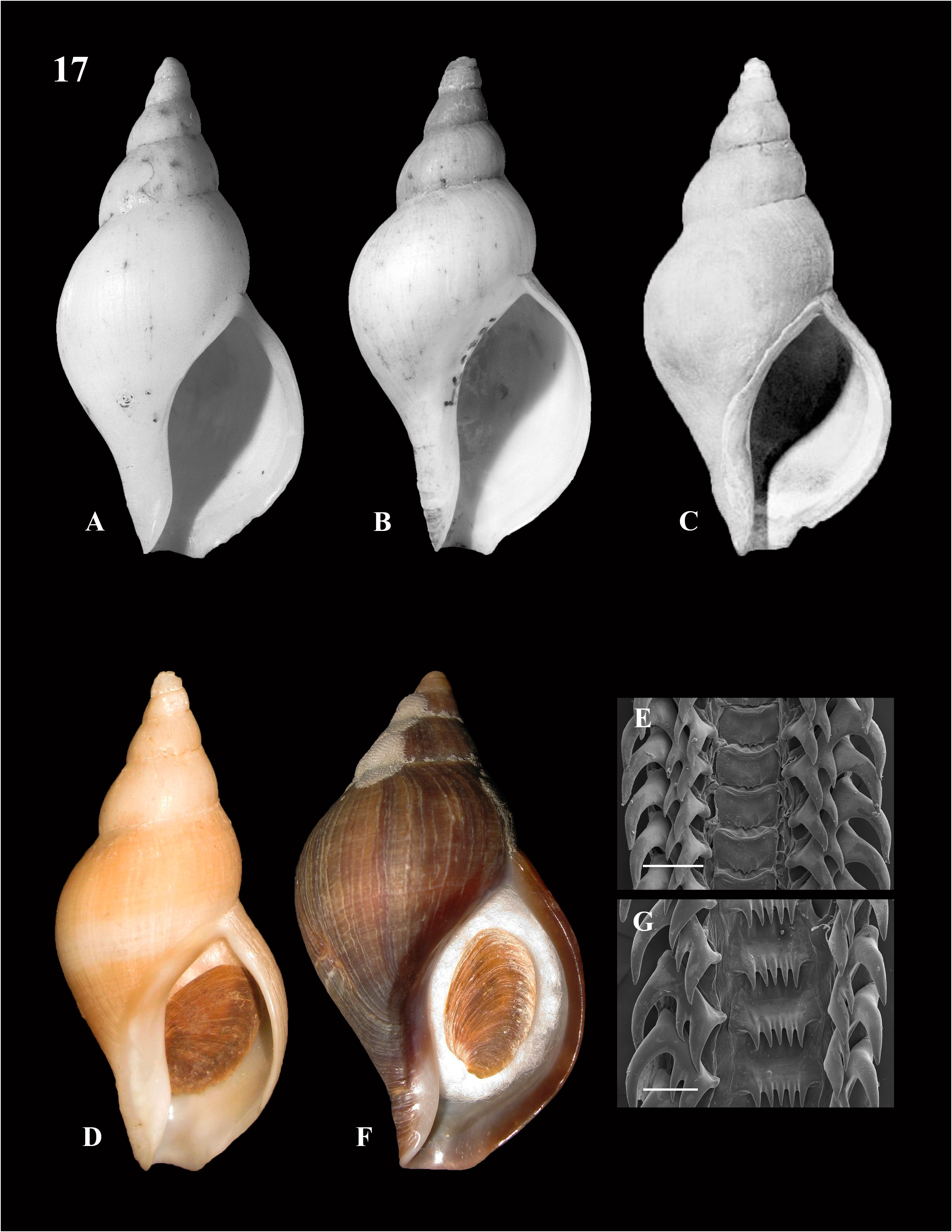
Neptunea harrisoni View in CoL n. sp.
Figure 17 A–E View FIGURE 17 urn:lsid:zoobank.org:act:42C04905-4531-4338-B116-49C9DFDF666B
Type locality: S of Tanaga, Andreanof Ids., Aleutian Is. , Alaska (51°47.52 N, 178°10.2 W), 146 m ( NMFS 95- 199401 - 122 ) GoogleMaps .
Type material: Holotype, SBMNH 169011 About SBMNH , 61.8 mm. (leg. William C. Flerx, 6 July, 1994) ; Paratypes: Pt 1, SBMNH 169012 About SBMNH , 75.6 mm. W of Buldir Island (52°19.26 N, 175°48.64 E), 219 m ( NMFS 143-200401 - 163 ) GoogleMaps ; Pt 2, SBMNH 169013 About SBMNH , 67.2 mm. W of Tanaga Island, Andreanof Ids. (51°44.31 N, 178°09.16 W), 88 m ( NMFS 23-199701 - 132 ) GoogleMaps ; Pt 3, SBMNH 169014 About SBMNH , 46.1 mm. Stalemate Bank (52°56.06 N, 170°25.73), 185 m ( NMFS 147-200401 - 221 ) ; Pt 4, USNM 122648 About USNM , 66 mm. S of Unimak Island, Fox Ids. (54°14 N, 164°35 W), 108 m GoogleMaps ; Pt 5, USNM 1606667 About USNM , 43.7 mm. S end of Samalga Pass (52°39.68 N, 169°21.15 W), 118 m ( NMFS 23-199601 - 1 ) GoogleMaps ; Pt 6, LACM 3633 About LACM , 61.4 mm. Tanaga Bay , Tanaga Island, Andreanof Ids. (51°44.5 N, 178°07.68 W), 95 m ( NMFS 23-199701 - 137 ) GoogleMaps ; Pt 7, LACM 3668 About LACM , 42.5 mm. N end, Adak Strait , Andreanof Ids. (51°56.25 N, 176°50.33 W), 95 m ( NMFS 23-200001 - 112 ) GoogleMaps ; Pt 8, LACM 3636 About LACM , 72.9 mm. SW of Amlia Island, Andreanof Ids. (51°51.49 N, 174°01.58 W), 150 m ( NMFS 94-199401 - 132 ) GoogleMaps ; Pt 9, CASIZ 153709 , 55.7 mm. Seguam Pass (52°19.8 N, 172°45 W), 444 m ( NMFS 94-200001 - 67 ) GoogleMaps ; Pt 10, CASIZ 137761 , 29 mm. N of Atka Island, Andreanof Ids. (51°52.8 N, 174°33.6 W), 137 m ( NMFS 94-200001 - 90 ) GoogleMaps ; Pt 11, RNC 4818 , 53.6 mm. Seguam Pass (52°49.7 N, 171°29.2 W), 209 m ( NMFS 23-200001 - 80 ) GoogleMaps ; Pt 12, RNC 4916 , 72.3 mm. S of Umnak Island, Fox Ids. (52°39.82 N, 168°56.18 W), 142 m ( NMFS 132-200501 - 2 ) GoogleMaps . Pt 13, Koen Fraussen Coll., 52.2 mm. S of Kanaga Island, Andreanof Ids. (51°39.29 N, 177°26.86 W), 133 m ( NMFS 143-201001 - 163 ) GoogleMaps ; Pt 14, David P. Berschauer Coll. 62.6 mm. S of Herbert Island, Islands of four Mountains (52°29.3 N, 171°06,7 W), 330 m ( NMFS 23-1997 - 1-52 ) GoogleMaps .
Referred material: RNC 4616 , 1 sp. , 70.9 mm. E of Semidi Islands (56°05.55 N, 156°17.03 W), 215 m ( NMFS 143-200301 - 117 ) GoogleMaps ; RNC 4712 , 1 sp. , 61.2 mm. W of Trinity Islands (56°35.5 N, 152°29.28 W), 145 m ( NMFS 134- 200501 - 132 ) GoogleMaps ; RNC 4909 , 8 sp. , 5.1–35.3 mm. Adak Strait , Andreanof Ids. (51°54.68 N, 176°52.4 W) 212 m ( NMFS 23-199701 - 171 ) GoogleMaps .
Description: Shell relatively small (Height to 75 mm, SBMNH 169012) fusiform, usually slightly concave on shoulder color white or light reddish brown, with narrow white band at mid-whorl; periostracum extremely thin or absent. Whorls rounded, suture weakly impressed, axial sculpture absent, spiral sculpture absent or only very faintly indicated. Protoconch small, smooth, with 2.5 whorls, teleconch with four whorls; Aperture oval, less than half of shell height; canal short, broadly notched; operculum large, but not filling aperture.
Radula: Rachidian tooth broad, rectangular, anteriorly edge broadly indented and bearing a thickened ridge; posterior edge with four very small, subequal cusps. Lateral teeth tricuspid, outer cusp long, thick, strongly curved, very slightly recurved at tip; central cusp considerably shorter; inner cusp about one third longer and nearly twice as thick as inner cusp.
Remarks: Originally thought to be the enigmatic “ Volutopsius ” callorhinus Dall. 1877, based on a broken and badly eroded shell found near the Pribilof Islands. That species is now placed in the genus Anomalisipho Dautzenberg & Fischer, 1912 (Merkuljev, 2015; Clark, 2016). “ Volutopsius ” callorhinus is presently considered to be a synonym of Anomalisipho rodgersi (Gould, 1860) , characterized by very fine spiral sculpture, ranges from the Pribilof Islands, Bering Sea, Alaska, north to near Barrow, Alaska, in the Chukchi Sea (Arctic Ocean). It is not present in the Aleutian Islands.
Etymology: The name honors Robin C. Harrison, Fisheries Biologist National Marine Fisheries Service (Alaska Fisheries Science Center) retired.
Distribution: Found all along the Aleutians, from Stalemate Bank, W of Attu Island, Near Ids. (170°58.73 E) East to the Trinity Islands, SW of Kodiak Island (156°35.5 W) in the western Gulf of Alaska, at depths of 87– 330 m.
Habitat: Found on bedrock, cobbles, gravel and black sand with bottom temperatures of 3.5°–5.6°C.
No known copyright restrictions apply. See Agosti, D., Egloff, W., 2009. Taxonomic information exchange and copyright: the Plazi approach. BMC Research Notes 2009, 2:53 for further explanation.
|
Kingdom |
|
|
Phylum |
|
|
Class |
|
|
Order |
|
|
Family |
|
|
Genus |